The remnants of Tropical Storm Zeta continues to result in rain across our area through the PM. Our radar is busy tracking all the rain. Northeasterly winds will increase some this afternoon and early evening; the strongest closest to the coast. #pawx#njwx#dewx#mdwx
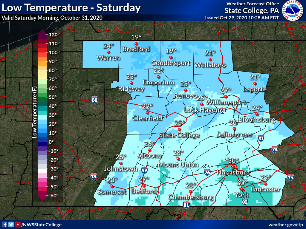
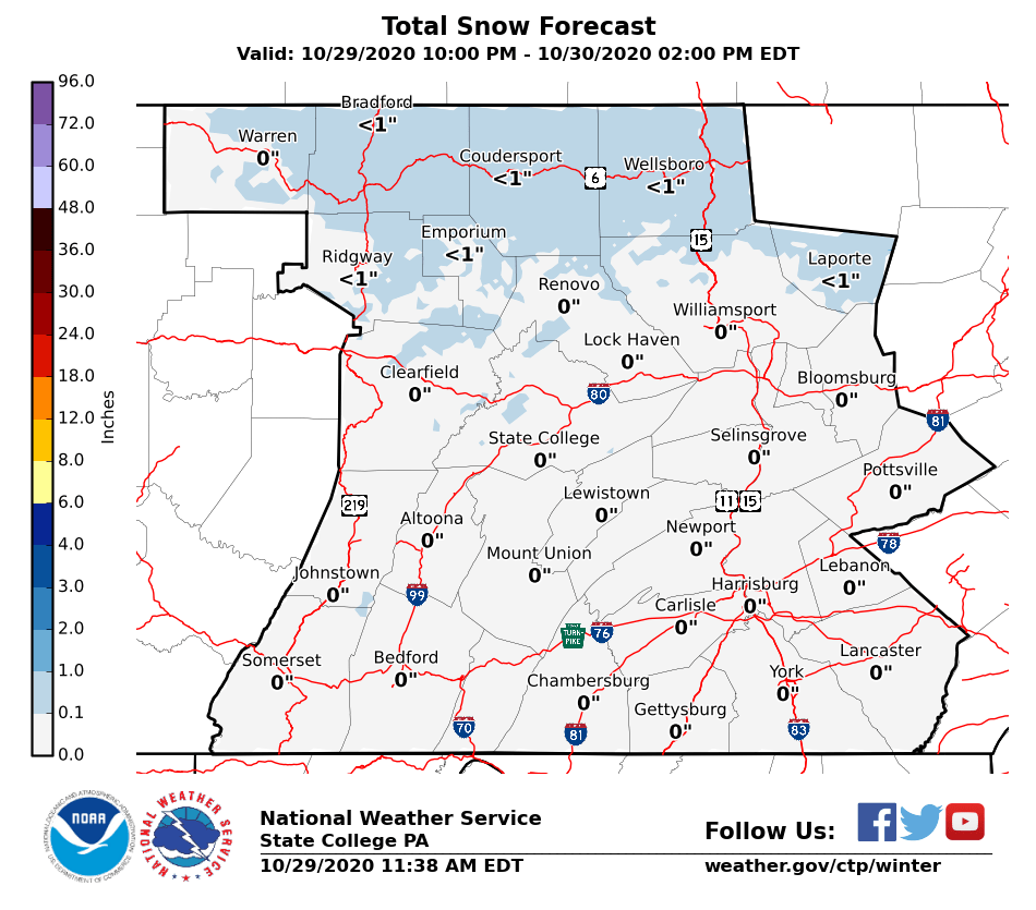
Turing colder after today's soaking. A changeover to snow is expected across the northern mountains overnight, with only minor accumulations expected. After that, a widespread freeze is expected Saturday morning, ending the growing season for the remainder of central PA. #ctpwx
OVER THE GULF OF MEXICO - Inside the eye of then CAT3 Hurricane #Laura seen from the flight station of @NOAA WP-3D Orion #NOAA42 "Kermit" during the Aug. 26th morning mission. Credit: Lt. Rannenberg NOAA Corps. Follow @NHC_Atlantic for latest forecast and advisories. #FlyNOAA
Here's our 4th pass into the eye of #Laura today. She was a Category 3 at the time, but has rapidly intensified into a Category 4. Please take this storm seriously.
Listen to your local officials.
Follow @NHC_Atlantic.
Stay safe.
#FlyNOAA
#ARRL and #AmateurRadio Emergency Communications Volunteers are monitoring the current storm activity very closely. Check in with our 2020 Hurricanes response page for resources, news, and media hits. https://t.co/PLirpNGZeH
OFF HISPANIOLA - Lightning within TS #Laura seen from @NOAA WP-3D Orion #NOAA42 "Kermit" during this morning's flight. Credit: Nick Underwood, NOAA. Follow @NHC_Atlantic and your local @NWS forecast office for latest forecast and advisories. #FlyNOAA#Stormhopper#NOAAat50
Signal intelligence gathering during #WWII brought together an unlikely pair, the Women's Signal Corps & a Virginia farm. A horse barn was even converted to the station's intercept & decoding space!
#Signal160#ArmySignalCorps#ThrowbackThursday
While KDIX is down for the next 2 weeks for the upgrade, you can use surrounding radars and regional views on the NWS website. You can also use MRMS data on this website:https://t.co/7NUgLEoik6 Here is the reflectivity at the lowest elevation as of 11 am. #PAWX#NJWX#DEWX#MDWX
Make sure to tell us what type of precipitation you are seeing out there this morning. Zanesville is currently experiencing freezing rain. Snow in Dubois and Franklin-- where colder temperatures are lingering in the mid-20s.
6:30AM Radar Update: A band of snow showers is moving across Central PA this morning. Reduced visibility and a quick accumulation of snow is expected. The snow may be mixed with ice pellets as well (yellow areas on right pane). #PAwx
Many folks will wake up with some snow on the ground Saturday morning. After a few dry hours, precipitation will return as a wintry mix before transitioning to all rain by the afternoon. #PAwx#OHwx#WVwx#MDwx
1/17/20: Snow arriving late tonight will be the start of a complex & messy winter storm for Saturday.
❄️Wintry wx expected in any one spot for 10-12hr period w/ some breaks
❄️Snow, sleet, ice and rain all in play
❄️NWPA lake effect snow Sat PM-Mon
Be safe. #PAWX@PEMAHQ
Join us at 3 PM EST, on Jan 8th for the EMI e-Forum: Just in Time Recovery Management Training: What You Need to Know When It Counts!
Login link: https://t.co/QOLHnDPjDB
Conference call-in: 800-320-4330, PIN 107622
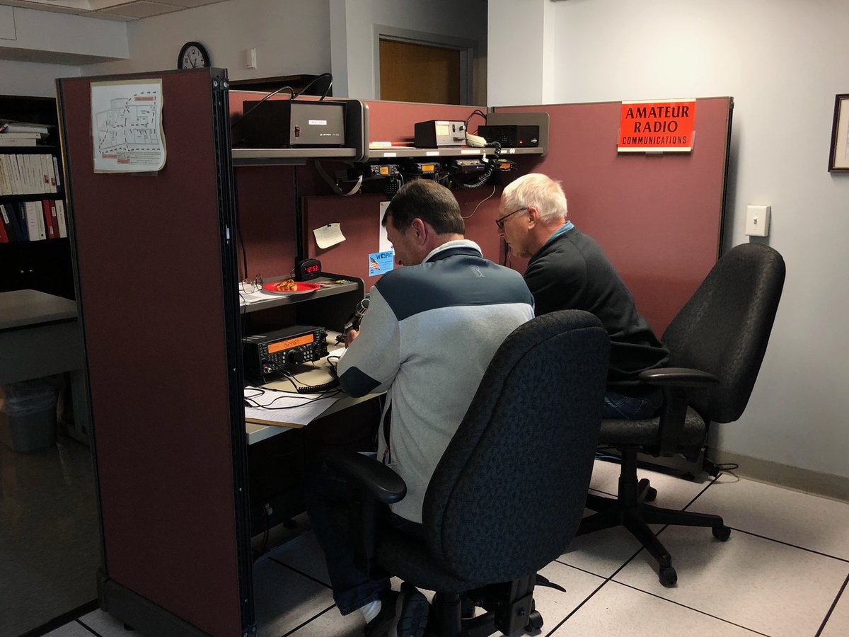
It is SKYWARN recognition day at our office! Amateur radio operators comprise a large percentage of the SKYWARN™ volunteers across the country. Amateur radio operators also provide vital communication between the NWS and emergency management if communications become inoperative.
(1/3) We will be taking check-ins as WX3CTP on VHF tomorrow 12/7 from 1030AM-1230PM for SKYWARN Recognition Day #skywarn19
We encourage all of our regional #hamradio operators to participate! #PAwx
(2/3) Remember to give your call sign, signal report, QTH (city and county), spotter number if any, & a 1-2 word description of the weather at your QTH. WX3CTP does NOT have HF capability, however a number of other NWS offices do. You can see them here: https://t.co/UkeraUtvlG
12/04/19: Accumulating, lake effect snow kicks in later this morning lasting into Thursday AM, with greatest impacts in the NWPA snowbelt counties. Additional snow expected for Laurel Highlands. Monitor conditions if you're traveling. @ReadyPA #PAWX