9AM EDT #Milton Position Update: Rush to complete all preparations this morning to protect life and property in accordance with your emergency plan. Visit https://t.co/tW4KeGe9uJ for the latest information
10 pm - Category 5 Hurricane #Milton near the northern Yucatan Peninsula. The hurricane poses an extremely serious risk to Florida. Here are the Key Messages. Visit https://t.co/tW4KeGe9uJ for details.
All eyes are on this #MLKWeekend Winter Storm which will impact millions while moving up the eastern seaboard. #GOESEast is on it. Every weather type is expected: rain, thunderstorms, heavy snow, freezing rain and dangerous icing. Check https://t.co/WCLxtW2Ob8 for local details.
Global Average Annual Insured Losses from Extreme Events in Excess of $100 Billion, New Report Finds via @ijournal @AIRWorldwide @Verisk
https://t.co/prppdDFyRx
Significant swells from Hurricane Larry should reach the U.S. East Coast & Atlantic Canada by midweek & continue through the end of the week. These swells will likely cause life-threatening surf & rip current conditions. Please follow the guidance of lifeguards & local officials
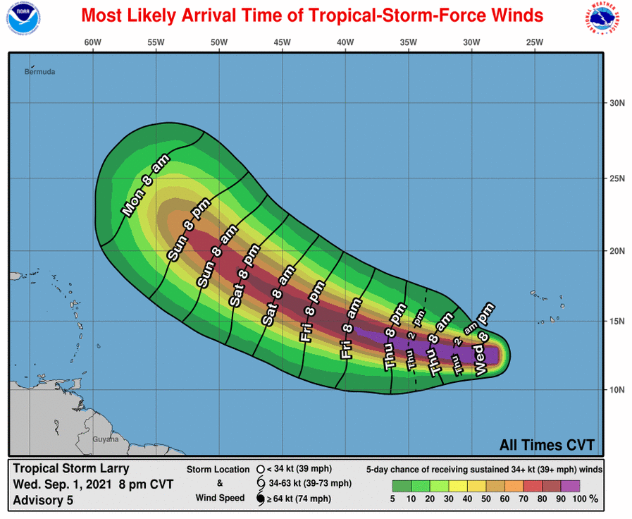
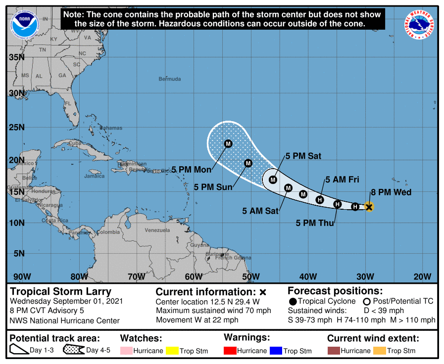
Tropical Storm #Larry has rapidly intensified since this time yesterday and is expected to become a hurricane tonight over the eastern Atlantic. Larry is forecast to move over the waters of the eastern and central tropical Atlantic through Monday.
https://t.co/oLAjv14a4R
This is an animation of GOES-16 infrared images of Hurricane Ida every minute showing the rapid intensification over the Gulf of Mexico, landfall at Port Fourchon, and inland track across Louisiana. Latest WPC Storm Summary: https://t.co/fql3z6otCV
5 pm Fri..the center of Hurricane Ida is approaching western Cuba moving to the NW at 15 mph with max winds of 80 mph. Steady-rapid strengthening is expected this weekend & Ida is expected to be an extremely dangerous major hurricane when it approaches the northern Gulf coast Sun
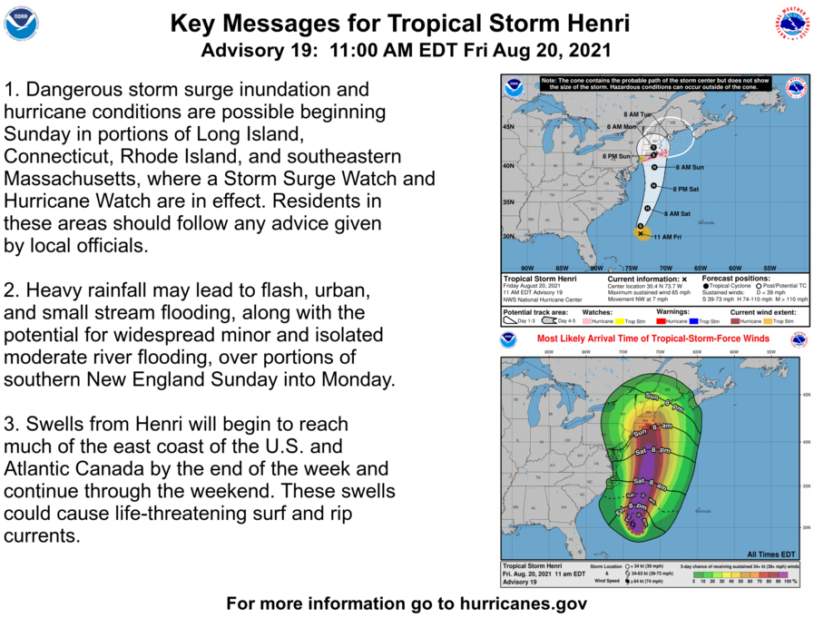
Tropical Storm #Henri expected to strengthen soon. Hurricane Watches and Storm Surge Watches are in effect for portions of the northeastern U.S. See https://t.co/tW4KeFW0gB for details.
Sunrise as #Hurricane#Grace moves inland across the #Yucatán Peninsula of #Mexico
After weakening today, Grace is forecast to re-strengthen overnight and approach eastern mainland #Mexico late Friday
Keep up to date with the forecast @conagua_clima@NHC_Atlantic
Lots and lots of heavy rain falling across the FL Panhandle with Flash Flood Warnings going into effect. Up to 12 inches of rain could fall in some parts of the region with water covered roads likely. Remember to turn around, don't drown.









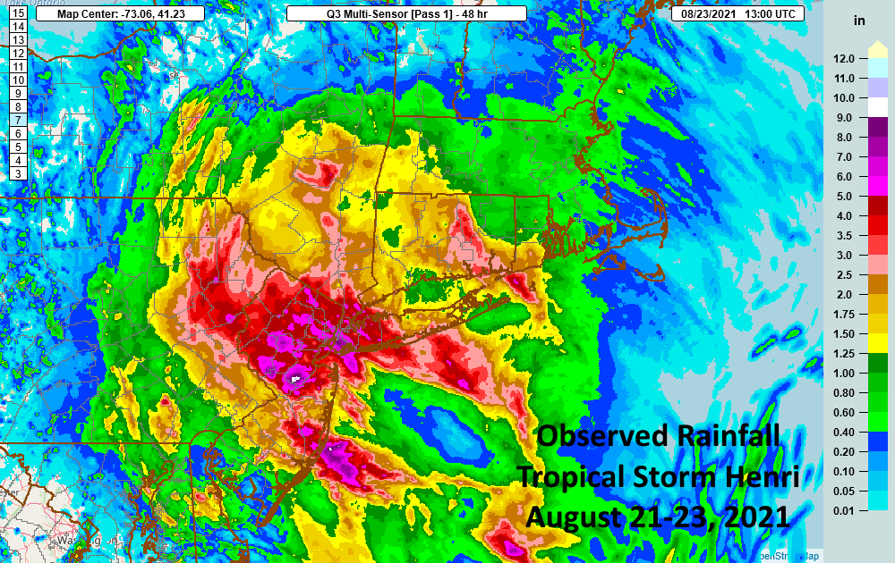
![NWSBoston's tweet photo. [Preliminary Observed Rainfall] here is the latest observed rainfall totals from yesterday & last night. A complete list is here https://t.co/mPgJqelUI4 #flashflooding #MAwx #RIwx #CTwx #Boston #Providence #Hartford #Worcester https://t.co/L2Uj82DsnI](https://pbs.twimg.com/media/E-SjF4cVUAIlpAk.jpg)