Looks like a portion Loudoun got a bit unlucky here and ended up seeing an actual tornado warning early around 11am. Schools did do a shelter-in-place and afternoon dismissal "will be on time", per LCPS.
Loudoun County Public Schools will continue to monitor weather conditions and is NOT planning an early dismissal at this time. All after-school activities and programming across all campuses and administrative offices are canceled today, Monday, March 16, 2026. Should it be necessary to delay dismissal times, we will communicate with families. Check phones and emails, or visit https://t.co/royfu4Wpai for more info.
Loudoun County Public Schools is monitoring the potential for severe weather on Monday, March 16, 2026. Families are asked to monitor their phones and emails in case the weather affects the school day. Information will be posted as it develops on https://t.co/cEap40dWsE
Now that decisions are being made, I can say that it is probably likely that after-school activities will be cancelled and our chances of early release is growing
5 p.m., 3/15/26: Due to the forecast for severe and dangerous weather, including potential tornadoes in the afternoon, all schools will close 2 hours early on Monday, March 16. Details at https://t.co/YkWWVk6UDe.
MCPS is monitoring the potential for a strong storm for Monday, March 16, and will announce any updates concerning operations, including any cancellations of activities or an early dismissal on Monday morning.
Visit the MCPS website for more information.
The entirety of Loudoun County could see a rare and significant severe weather event, including a 15% risk of tornadoes and a 60% risk of damaging winds (as of now).
Dismissal and after-school activities could be affected by this, as the storm is expected to arrive around 4 PM.
Loudoun County Public Schools will open on a two-hour delay on Tuesday, March 3, 2026. Admin offices will open on time. For more info: https://t.co/cEap40dWsE
Now that the first flakes are falling, here is our prediction!
Temps will drop below 32F tonight, meaning paved surfaces will have a nice coating of an inch + some ice by morning.
Temps should be above freezing after around ~9AM, which is why we are leaning towards a delay.
This storm ended up being a complete hit and miss😢
The highest totals for us are around IAD, with ~3.0 inches, with most of it melting today.
We shall have better chances next year
❄️ UPDATED WEATHER ALERT FOR MONDAY, FEBRUARY 23, 2026
All FCPS schools and central offices are closed Monday, February 23. Essential personnel should follow supervisor direction. More updates available on the FCPS website (https://t.co/pybAQOAoiW).
Due to the potential for inclement weather, all activities on LCPS campuses are cancelled after 6 p.m. Sunday, February 22, 2026, and campuses will close. For more info: https://t.co/cEap40dWsE
Unfortunately, we were right on the edge of a major snowstorm and seeing over a foot, however we will at least hopefully see 4 inches.
It is also important to note that VDOT is not treating roads due to rain, so roads will not be in the best shape in the coming days.
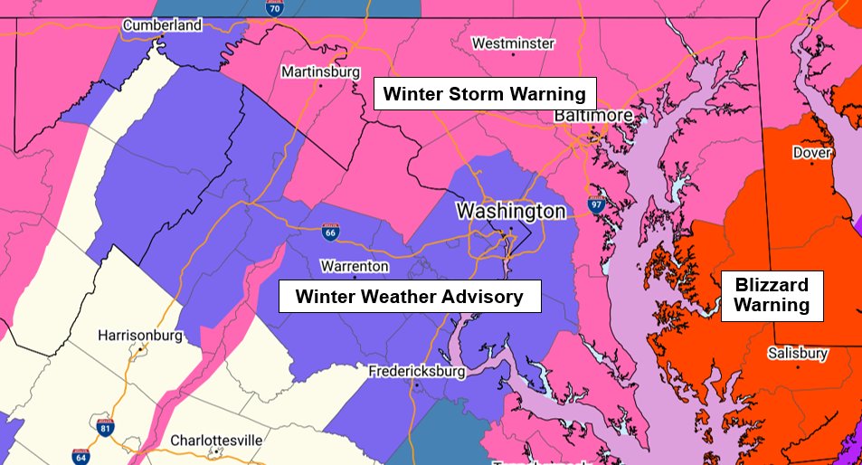
The National Weather Service has updated their alerts for the storm. These are in effect late Sunday afternoon into Monday morning:
* The Beltway area is now under a Winter Weather Advisory.
* A more significant Winter Storm Warning has been issued for areas west, north, east, and southeast of the Beltway area, where NWS expects heavier snow that could reach or exceed 5 inches.
* Blizzard Warning on the Eastern Shore (yikes!!)
SnowCon: 5/5
Trend: ⬆️
Several inches of snow are looking likely across the region with the heaviest expected to fall north and east of the I-95 Corridor.
Though, models STILL haven’t gotten their act together and remain keeping this a very difficult forecast for our region. (And it is driving us crazy!)
A rain/snow mix is expected to begin Sunday morning before transitioning to snow. The worst impacts will likely occur once the sun sets through Monday morning.
We will probably see impacts towards the Monday morning commute as light snow is expected to continue during this time frame, so school closures and delays cannot be ruled out.
We will be working on a second call throughout the afternoon and should have it out by the evening. Stay tuned! #vawx #mdwx #dcwx #wvwx
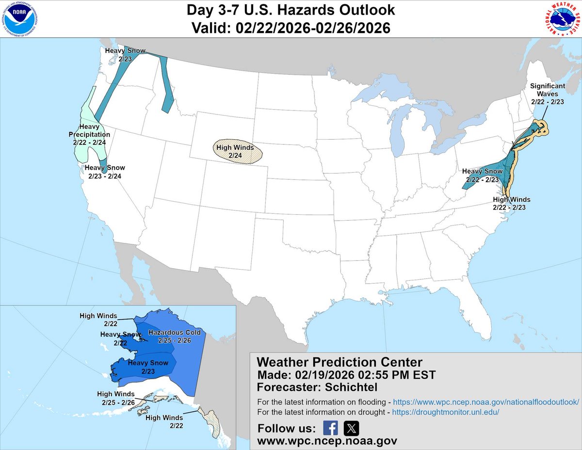
A large winter storm (even larger than the one last month) is possible this Sunday-Monday. Stay tuned for changes.
Closure updates will be made Early Sunday.
National Weather Service now at a 50-80% chance of a “winter storm warning” level impact (5”+ snow) DC & northeast. 80%+ on the Eastern Shore & New Jersey.
They’ve raised their threat risk to “Elevated” for much of the area.
National Weather Service highlighting "potential" for heavy snow Sunday-Monday (Sunday night main period of interest). Afternoon models did gently go in a snowier direction. We need to see if it was a blip or a trend. We'll post an update on tonight's (Thursday) models around 1130-11:45p.
Extreme cold and wind chill persists throughout Monday, meaning early morning freeze remains a threat.
Temperatures reach as low as 8°F around 7am, which is not ideal for Elementary students. We will see how LCPS determines what is considered too cold.