A massive slight risk is in place from the Northeast Canadian border to the Southern Appalachian’s for severe wind gusts. 30% wind probabilities have been issued for southern New York to central Virginia where higher confidence in severe winds exists.
Another slight risk has been drawn for the Panhandle region and SE Colorado where gusty storms with isolated tornado potential may evolve. There is also a threat for severe hail as well.
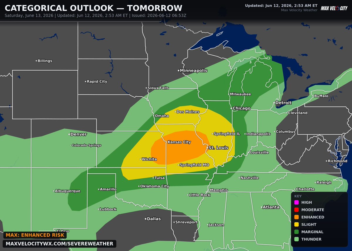
Another enhanced risk has been issued from Eastern Kansas to St. Louis. This is another all-hazards risk. 5% tornado probs have been drawn up for northern MO including Kansas City. The enhanced risk is for severe wind gusts. 75+ MPH winds are possible. Significant hail is also possible depending on storm mode. Supercells are possible but higher confidence lies in linear storm mode.
Here we go again....
Multiple lines of severe storms are likely tomorrow night, stretching from Wisconsin to Texas. The greatest threat will be in Kansas, Missouri, and Illinois, where large hail, significant damaging winds, and a few tornadoes will be possible.
Live stream appears likely.
A Level 2 risk is up today across a long stretch of the East, from the Appalachians through the Mid-Atlantic and into the Northeast.
Damaging wind is the main story here. Strong June heating on a muggy airmass is the fuel, and there isn't a ton of wind shear to organize things, so think scattered storms collapsing into clusters and pushing out gusty downburst winds this afternoon and evening.
A stray bit of hail or a brief spin-up is possible, but the thing to watch for near you is a fast-moving storm knocking down limbs and powerlines. Keep an eye to the sky later today.
Sunday night looks like a great one for dark skies, and there's a bonus.
The moon is completely gone, so the sky stays black from sunset to sunrise, perfect for stars and the Milky Way away from city lights. The cleanest air should be across the Intermountain West and Northern Plains, from Nevada and inland California up through Montana and the Dakotas.
There's also a chance for faint northern lights low on the northern horizon, maybe as far south as roughly Iowa or Nebraska to the eye, and a camera pointed north could pick up more color down near Chicago or Omaha. Best odds are up north. The Gulf Coast and Southeast will likely be socked in with clouds and humidity.
I think those back legs have a mind of their own. 😍
A baby Moose takes her first tentative steps under the watchful eyes of her mother in the Rocky Mountain National Park. ❤️
#Colorado#moose#RockyMountainNationalPark
🎦 Credit: Colorado Adventures.
Likely tornado damage near Dwight, Illinois, after a large stovepipe tornado passed through the area a short time ago!
Thank you to Danielle for sending this in!
Too often, cats who are incontinent and can't use their back legs get overlooked.
But thanks to an adopter, Noodle's whole world changed. But the icing on the cake for Noodle? Her very own set of wheels to help her get around. Just look at her go! 🛞💨