London based photographer. Always looking for models to shoot or test with: Fashion, Editorial, Beauty, Lingerie. Get in contact. Also do economics & politics
My Bundestag Speech / Bundestagsrede
Corona Downloads, 10min:
1. 🇬🇧Video with subtitles: https://t.co/XsIm8lEun4
2. 🇬🇧Text: https://t.co/MLFA5iomjs
3. 🇩🇪Video: https://t.co/r9q0P4TKHA
4. 🇩🇪Text: https://t.co/f4H6okvmr2
@fatemperor@alexberenson
Eine frühere Version dieses Tweets habe ich gelöscht, da die Untertitel noch nicht fertig waren.
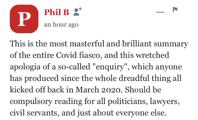
This "Phil B" comment on a Spectator article has inspired us to make the cover story - Prof. Carl Heneghan on Covid and the inquiry - free to read. https://t.co/ChVABV7eJA
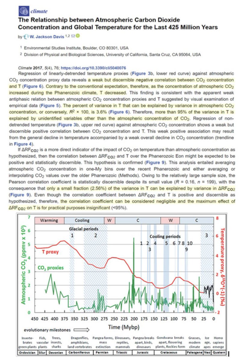
Possibly the best CO2 and Climate facts resource page I've seen - can download the many facts to share and discuss widely! (We NEED to discuss this, or the bad guys will ruin our world... 🤨)
https://t.co/sFBw7lGsdv
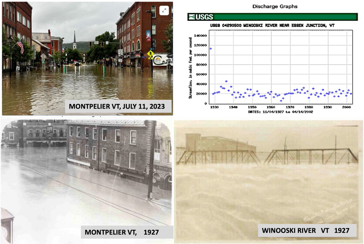
Dishonest Climate Fear-mongering headlines of the week goes to USA TODAY for posting
Dramatic flooding was rare in Vermont's capital.
Expect it more amid climate change.
Similar catastrophic claims were suggested throughout the click-bait media-verse from the NY Times, the Washington Post, CNN, etc, etc
Rarely does the media provide a scientific historical context, preferring to weaponize weather
But if you read the article Climate Variability and Socioeconomic Consequences of Vermont’s Natural Hazards: A Historical Perspective published by the Vermont Historical Society in 2002, you would realize the natural truth of Vermont's flooding.
The article states:
“One of the most pervasive hazards that impinges upon and marks the Vermont landscape is flooding… Rarely does a year elapse without a flooding event of a significant magnitude being reported in at least one of Vermont’s fourteen counties or perhaps statewide, making this the number-one hazard across the state.
Complex topographic barriers such as the Green Mountains and Taconics produces enhanced precipitation totals… Vermont’s steep V-shaped valleys help to constrain the flow, creating remarkable depths of flow at tremendous speeds.
As far back as 1853, Zadock Thompson noted these topographic characteristics along the Winooski, Lamoille, and Missisquoi rivers, such that by default, roads could only be constructed along the open valley floors, making them susceptible to flooding damage.
The Great Flood of 1927 resulted from record rainfall totals produced by tropical storm remnants on November 3, following October precipitation totals that were already 50 percent above normal. As this decaying storm tracked directly along the spine of the Green Mountains, streams rose so rapidly that there was little time for warning. The Winooski River rose 40–45 feet above its normal level, causing an estimated $30 million in economic losses.
The Montgomery flood of July 15, 1997 , In the towns of Montgomery, Montgomery Center, Lowell, and Wolcott at least 6 inches of rain fell in less than six hours.
Montpelier is particularly prone to flooding given its location in the Winooski River valley just upstream from the confluence with the Dog River.
Below are pictures: Montpelier Vermont from July 11, 2023 and 1927. In contrast to claims that global warming is causing more floods, the USGS discharge records show not even a hint of an upward trend. And the raging Winooski River in 1927
Greenpeace co-founder, destroys the "climate emergency" myth in under two minutes:
"For the last 300 years, we have been in a slight warming period. It started 150 years before we even used any fossil fuels, or emitted any CO2…”
Please take a good hard look at this UK Govt graph.
This is the totalitarian agenda behind the Net Zero scam and it’s 100% real.
Wake up before you’re starving, freezing, locked inside your home and prohibited to fly.
@UPS_UK three exception notices and a hefty customs charge. for what? I paid shipping, but dont have package. Getting close to 10 days. Sent you DM and called a lot