O caso de estudo ‘Modelling Ecosystem Services’ da ilha Terceira do @MOVEProject2018 🌱
🎯Análise dos resultados da utilização de diferentes dados de Ocupação e Uso do Solo e suas implicações no mapeamento da distribuição de serviços dos ecossistemas.
👉https://t.co/SI2bepEwlj
After 3 and a half years of work and with an European Commission co-funding close to 1 million, the MOVE project has ended with the mapping ecosystems and their services in 7 Overseas entities of the EU. Get to know out main outputs and the team behind it:
https://t.co/Ql6L3weSrU
MOVE project is coordinated by the @FRCTAzores from the Regional Government of the #Azores (Portugal). Carolina Parelho, as head of the coordination team and manager of the project, explains here the achievements, main results and future goals for MOVE:
https://t.co/1gLpd6RYOy
O @MOVEProject2018 permitiu alavancar a metodologia de cartografia, a avaliação dos ecossistemas e seus serviços #MAES nas #RUP s e #PTU da #UE - Açores, Canárias, São Marinho, Ilhas Falkland, Martinica, Ilha da Reunião e Guiana Francesa.
👇👇👇
https://t.co/gjuA0HpVhG
MOVE project intends to involve policy makers, researchers and the civil society in the development of methodologies for mapping and assessing the state of ecosystems and their services in EU´s ORs and OCTs.
📌 We are proud to share with you this MOVE promotional video, that we have prepared to disseminate the project main achievements.
Hope you like it!
Please share this video to spread the message.
https://t.co/i9MtNl4Lnq
We celebrate today #WorldOceanDay. It reminds everyone of the major role the oceans have in everyday life. They are the lungs of our Planet and a major source of food and medicine and a critical part of the biosphere. We must protect and preserve healthy #marineecosystems.
This module deals with "ex situ marine conservation and its relationship with MPAs".
You can access the content resources, available in French and English, through the following links, until 13th June 2021:
https://t.co/Kxv9oB85Kq
https://t.co/xbcvUsBagb
MOVE project participates in MOOC Conservation, a platform dedicated to providing online courses on nature conservation. The MOOC about “Marine Protected Areas” contains a module coordinated by researcher Fran Otero from IU-ECOAQUA, one of MOVE’s partners.
Have a read of our latest paper about the giant #kelp forests surrounding the Falkland Islands🌊🌿👌
We estimate the extent and value of ecosystem services from #fisheries, #bluecarbon sequestration & nutrient cycling, and recommend future research areas https://t.co/psWCiLHW21
O #FRCAzores, em colaboração com a @Univ_Reunion e @seasktch, organizou o workshop "Ferramentas de apoio à decisão - o SeaSketch como suporte ao Ordenamento do Território focado nos Serviços dos Ecossistemas", no âmbito do @MOVEProject2018.
Saiba mais em https://t.co/Mm8DBo3sOs
The event was attended by Azores regional stakeholders with relevance in the areas of environment, biodiversity, land use and ecosystem services in the Azores.
MOVE Project, with an action coordinated by @FRCTAzores (along with @univ_reunion and @seasktch team), held this Monday an online workshop entitled in English: “Decision support tools - SeaSketch as a support to Spatial Planning focused on Ecosystem Services".
👉 In case you couldn´t attend to our seventh (and final) MOVE Project webinar, focused on French Guiana, remember that you can find a video and a resume in our website:
🔹 RESULTS: https://t.co/VKM14Zfzoc
🔹 NEWS: https://t.co/yVHaJo52y0
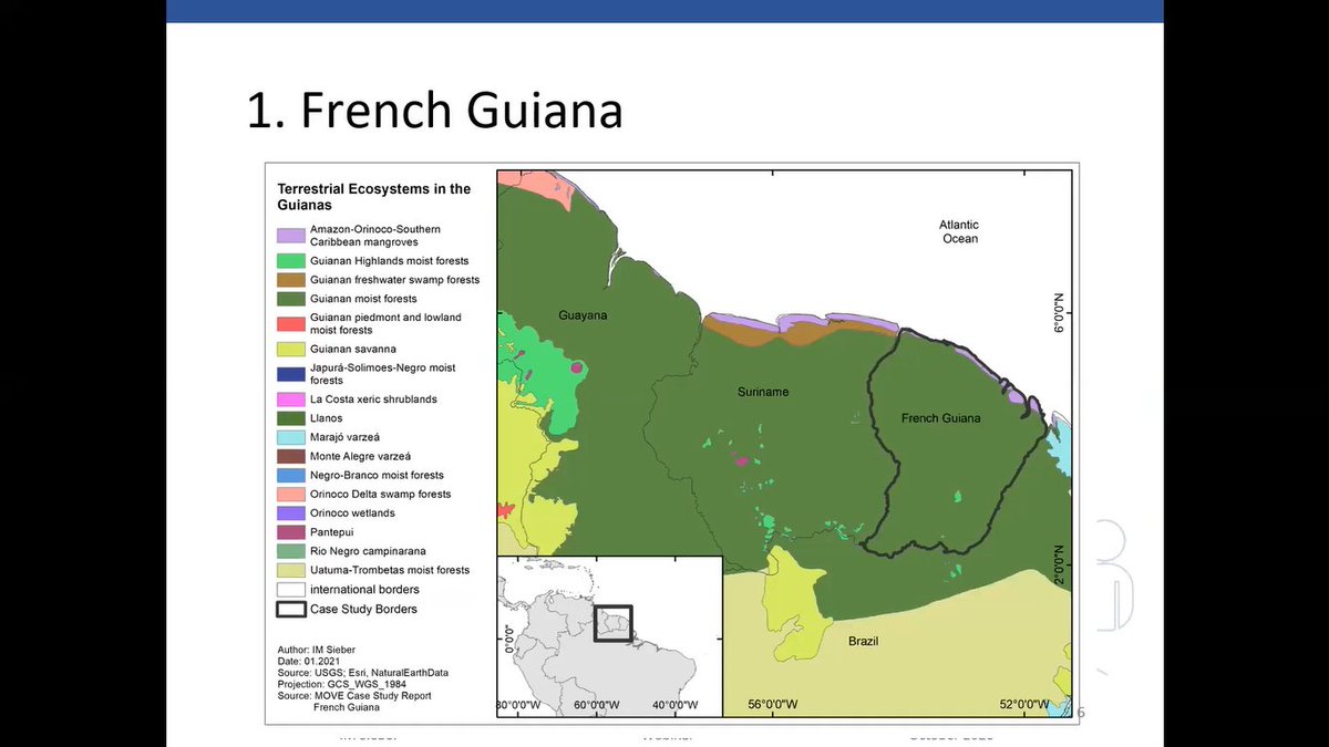
MOVE are holding their final Webinar of the series on 9 February. Join Ina M. Sieber, Researcher & Lecturer from Leibniz University, for a fascinating insight into land use & ecosystem services in French Guiana. Register here👉 https://t.co/vLOIerys65
@MOVEProject2018 @im_sieber
We remind you that MOVE project will present the case study of the #FrenchGuiana on February 9th, the seventh and final MOVE webinar. The talk will be presented by Ina Sieber (Leibniz University Hannover).
✔ Register: https://t.co/zB5jKr3j7O
📌 Deadline for registration: 7FEB
MOVE will present the case study of the #FrenchGuiana on February 9th. The talk, presented by Ina Sieber (LUH), will focus on an assessment of land use changes based on different spatial imagery classifications.
✔ Register: https://t.co/mWrsVQKhd8
📌 Deadline: 7 February 2021