An EF-0 tornado briefly touched down and left multiple trees uprooted and several homes damaged in the Saddlebrook Farms subdivision near Grayslake Wednesday evening. https://t.co/hGyt9Pi0e1
Illinois has broken the state record of tornadoes in a given year. So far in 2026, Illinois has a confirmed 143 tornadoes breaking the record set back in 2024 of 142. #ilwx
So let me get this straight: in the UK, a 15-year-old can’t be trusted with social media, but an 11-year-old can be trusted to make life-altering medical decisions that could leave them infertile for life. To protect the children, of course.
Good evening, does anyone up in Lake County, IL know of any tree or powerline damage in this area highlighted on the map? If so, we'd be interested in knowing the exact location. Any pictures would be helpful too! Thanks! #ilwx
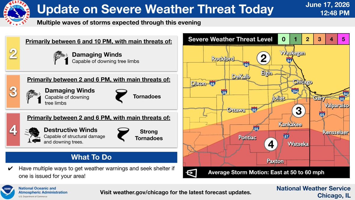
The threat for significant severe weather has shifted farther south in the wake of the AM storms, focusing near and south of a Pontiac to Rensselaer line. A severe weather threat remains across the rest of the area, however. Have multiple ways to receive warnings! #ILwx#INwx
Moderate Risk for Flash Flooding across northern Illinois on Wednesday focusing on Wednesday afternoon and evening across northeast Illinois. Excessive concrete and torrential rainfall could lead to flash flooding especially in low lying areas. #ilwx
A warm front will dictate the highest threat area for tornadoes tomorrow. Plausible scenarios include the front making it far north as I-80, to remaining farther south. Storms are still expected north of the front with a threat for damaging winds & flash flooding. #ILwx#INwx
1230pm: Very little changes in the midday SPC update. A tornado outbreak is very possible across portions of northern and central Illinois into Indiana tomorrow. A morning round of thunderstorms will move through northern Illinois beginning around daybreak. These morning storms could be capable of damaging wind gusts and large hail. They will continue through late morning ending early tomorrow afternoon. A warm front will be surging northeast across central Illinois into northern Illinois tomorrow afternoon. Along and just south of that front will be the focus for significant severe weather including strong to violent long tracked tornadoes. Models show this warm front stalling near the I-80 corridor. The second round will develop around 1-2pm and will intensify into late afternoon. North of the warm front across northern Illinois, storms will develop and could be capable of significant threat damaging wind gusts and hail but the main threat will be flooding with torrential rainfall likely. Storms tomorrow will be moving at highway speeds (55-70mph) so lead time for tornadoes may be limited so take shelter as soon as possible when a warning is issued. Also tornadoes may be wrapped in rain so visibility will be very limited and chasing will be difficult to impossible. Storms capable of significant tornadoes will progress east into northern Indiana tomorrow evening. 2pm-9pm is the window for strong, long-tracked tornadoes Wednesday. #ilwx