Salt Lake fire is dumping a lot of water on this fire, but it is burning hot and putting up a plume of toxic smoke.
Fire is reportedly affecting traffics southbound Redwood Rd at MP 59 Salt Lake Co.
369 South Orange Street, Salt lake City
Metech Recycling
Video: David Ochoa
Fire danger will increase across Utah on Wednesday — especially in southern and western parts of the state — as gusty winds, hot temperatures, and dry thunderstorms develop. #utwx
I’ve raised the temperature forecast for Mother’s Day — it’s shaping up to be a very warm Sunday with highs reaching the 80s. Overall, the weekend looks pleasant, dry, and perfect for outdoor plans. Enjoy! #utwx
The pattern remains unsettled into next week, with our best chances for rain coming Sunday and Monday. Another system might bring additional showers Tuesday and Wednesday. We could really use it! #utwx
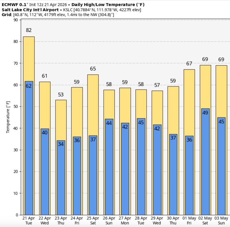
Enjoy it while it lasts—today looks like our final day in the 80s for a while. A cooler pattern settles in after this, with highs mostly in the 50s and 60s along the Wasatch Front over the next couple of weeks. #utwx
POWERFUL COLD FRONT THURSDAY: A strong cold front moves through Thursday afternoon, bringing a quick return to winter along the Wasatch Front.
Timing for Salt Lake County looks to be mid to late afternoon, roughly between 2 & 5 PM (a bit earlier to the north, a bit later to the south along the Wasatch Front). Rain will change to snow pretty quickly as colder air moves in, with snow levels dropping right to the valley floor.
This could create some slick conditions for the evening commute and will likely impact any outdoor activities Thursday afternoon and evening.
There’s also a chance for lake-enhanced snow Thursday night into early Friday, which could add a bit more accumulation and create issues for the Friday morning drive. #utwx
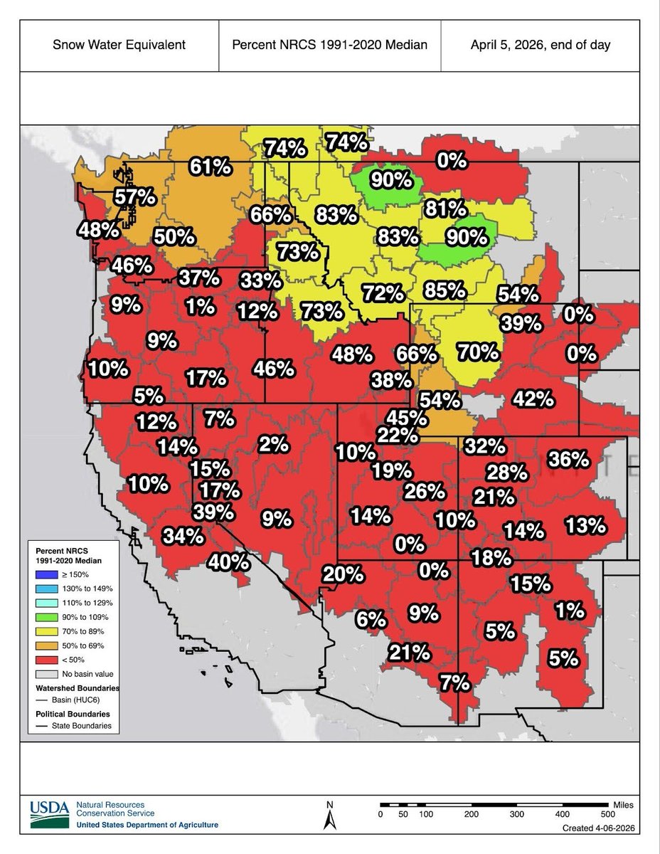
April Snow Drought Update
A March Meltdown: Historically Low Snowpack Melts Across the West, Signaling a Dire Water Supply Situation
Many critical economic sectors like ag, energy, and recreation have been or will be impacted.
See https://t.co/rCdLt1Gzmi @NOAA@WRCCclimate
The mountains in Utah can expect about 3-8" of snow Tuesday PM through Wednesday AM. The Cottonwoods could get more with 5-10" expected. #utwx
A colder storm will move in Thursday through Friday.
What a day ☀️
Spent some time soaking up the sunshine while working live on the air, taking in a record-tying high of 79°. Hard to beat blue skies and that early spring warmth finally settling in.
And we’re not done yet… even hotter temperatures arrive tomorrow.
Utah’s statewide snowpack for the 2025–2026 season will likely peak at just 8.4 inches of snow water equivalent (SWE)—which would set a new record for the lowest peak on record.
With warm conditions ahead, it’s possible we could lose more than 2 inches of SWE by this weekend alone. #utwx
Don’t forget about our weekend cold front!
While most of the attention is on next week’s potentially historic March heat wave, we’ll first see a small storm move through on Saturday afternoon and evening.
🌦️ Isolated showers and thunderstorms will be possible across northern Utah as the front passes.
Then a big change:
🥶 Saturday night into Sunday will turn much colder, so be ready for a quick taste of cooler weather before the heat arrives next week.
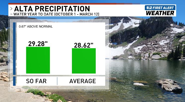
This might surprise you! ⛰️
Even though we’ve had a historic low snowpack this winter, total precipitation at Alta is actually near average.
From October 1 – March 12, Alta has picked up 29.28" of precipitation, which is about 0.67" above the 30-year average for this point in the water year.
So why is the snowpack so low? 🌡️
Mild temperatures have played a big role. Many storms this winter have been warmer, producing high water-content snow and even rain at times in the mountains.
The result: near-average precipitation, but snow totals running about 10 feet below average at Alta specifically.
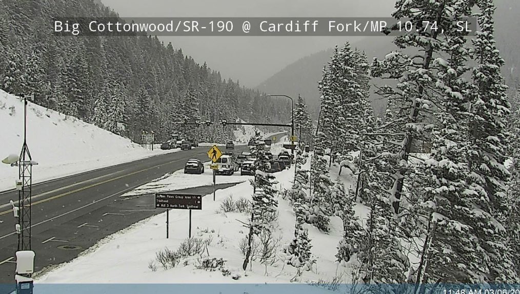
👋SR-190 ROAD CONDITIONS
Lower-mid: wet
Upper: slush
🚨Traction devices are REQUIRED
‼️Crews are out: slow down and travel with caution to @SolitudeMTN@BrightonResort
Preliminary snowfall totals are in for our local ski resorts! Many areas have seen 1–2 feet of fresh snow. As our storm begins to wrap up, expect another couple inches through the afternoon—perfect timing for some late-day turns!
A cold front will move in around midnight and rain should quickly change to snow along the benches. It may take another hour or two for that changeover in the lower valleys. @MetStormKelly and I will break it all down for you on 2News at 4, 5 & 6 PM. See ya soon! #utwx