⛈️ La previsión no ha fallado y las #tormentas se han dejado ver por varios puntos de la Comunidad de #Madrid.
🌧️ A esta hora sigue lloviendo y ya en algunos puntos superamos los 20 mm.
#Junio2026
🚨#HeadsUp: Early Polar SSW & Vortex Weakening Signal — Autumn 2026 .
Last year, I highlighted the potential for an unusually early and (rare occurrence) November Polar Vortex disruption and Sudden Stratospheric Warming events, months before it became widely discussed by forecasting centers and analysts .
🔗 See the 2025 early SSW forecast:
https://t.co/yBrHRW9iNT
This year, a multivariable framework incorporating solar, planetary, space-atmospheric weather, and stratospheric factors has been used to assess the upcoming season’s polar behavior .
After examining the latest analog composites (n=20, with additional supporting cases) and stratospheric diagnostics for November 2026, a SSW event signal is again emerging that warrants attention.
🔷 Key Signals
🔹 10 hPa temperatures indicate developing polar warming during the second half of November, with persistent anomalies extending across North America, Alaska, and parts of southern Europe between ~15–30 November.
🔹 30–100 hPa geopotential height anomalies show strong upward-propagating wave activity into the polar stratosphere, with indications of zonal wind deceleration and partial reversal above ~65–70°N.
🔹 The vortex appears increasingly susceptible to displacement and deformation, particularly during the 15–25 November window.
🔹 A coherent Rossby wave train is evident across multiple atmospheric layers, suggesting active troposphere–stratosphere coupling.
🔷 Interpretation
The current signal supports:
✔ Elevated probability of early-season vortex weakening
✔ Increased likelihood of a displacement-type warming event
✔ Enhanced planetary wave activity
⚠️ Moderate probability of vortex stretch / partial split
🔷 Key Uncertainty
I am not yet concluding a major SSW, but signals from this early outlook do support it.
The decisive factor remains:
Whether warming intensifies enough to produce a full zonal wind reversal at 10 hPa near 60°N. Yet this early analyses do point for definite reversal of wind. see comment.
🔷 Bottom Line
A dynamically active stratospheric regime is likely during late autumn 2026, with a credible signal for early vortex disturbance.
However, confirmation of a major SSW or full split remains conditional.
📊 The attached maps summarize the evolving signal.
More diagnostics (geopotential heights, wind anomalies, and vertical structure) are included in the thread.
⚠️ This forecast is probabilistic, not deterministic, based on composite analysis, AI-assisted downscaling, and advanced statistical methods.
Statistical Analog Model
By M. @Statisticizer
Chief Data Scientist — https://t.co/4PftHqD0mL
🇵🇹🇪🇸🌧️ #Europe 🇪🇺🌍Autumn 2026 Rainfall Outlook | SW Europe, Mediterranean & North Africa.
This outlook is based on 39 statistical analog years identified using pattern-recognition techniques and artificial neural network (ANN) methods. The maps show rainfall probability anomalies derived from historical seasons that most closely resemble the current climate configuration.
⚠️ This is a probabilistic climate outlook, not a deterministic forecast. It highlights areas where rainfall and storm activity were historically more likely, not guaranteed outcomes. Updates may occur as new atmospheric and oceanic data become available.
🍂 September–October
One of the strongest signals emerges over the Ionian Sea, extending into southern Italy, Sicily and western Greece.
Historically, such concentrated positive anomalies have often been associated with enhanced deep convection over the central Mediterranean. These hotspots represent a form of climatic severity memory, where many analog seasons produced intense convective outbreaks, heavy rainfall episodes and occasionally significant Mediterranean storms.
🌊 October–November
The signal strengthens further across the central Mediterranean, particularly around:
• Ionian Sea
• Southern Italy & Sicily
• Greece
• Malta
• Southern Adriatic
This pattern is historically associated with:
✅ Enhanced Mediterranean cyclogenesis
✅ More frequent Medistorms with Likelihoods of Medicanes ( mediterranean cyclones ) peaking between late September-October and Into November .
✅ Deep low-pressure development
✅ Increased storm-track activity
While no specific event can be forecast months in advance, the analogs suggest a background environment that may be more supportive than normal for significant Mediterranean storm systems and, under favorable synoptic conditions, occasional medicane-like developments.
Countries most exposed to this signal include #Portugal, NW #Spain #Greece, southern Italy, Sicily, Malta, Albania and parts of the western Balkans, with occasional influence extending toward western Libya.
🌧️ November–December
Storm activity appears to broaden geographically while remaining active across parts of the central and eastern Mediterranean. Positive rainfall anomalies persist over portions of southern Europe and North Africa, although generally less concentrated than during the October–November peak.
🇪🇸 Iberian Peninsula
The analogs consistently suggest a relatively active Atlantic influence during autumn.
September–October: Increased Atlantic moisture west of Portugal and northwestern Spain.
October–November: The wet signal strengthens west of Iberia, favoring Portugal, Galicia and western Spain.
November–December: Atlantic-driven rainfall opportunities continue, particularly across western sectors of the peninsula.
Overall, the analogs do not strongly support widespread persistent drought across Iberia during autumn. Instead, they favor recurring Atlantic moisture intrusions, especially for Portugal and western Spain. December may feature slightly more stable conditions in NW Spain.
📌 Key Takeaways
🔹 Strong convective signal over the Ionian Sea from early autumn.
🔹 Increased likelihood of Mediterranean cyclogenesis during October–November.
🔹 Higher-than-normal potential for Medistorm activity across the central Mediterranean.
🔹 Wetter tendencies for Greece, southern Italy, Sicily and Malta.
🔹 Continued Atlantic storm influence over Portugal and western Spain.
🔹 Gradual eastward progression of rainfall activity later in autumn.
Statistical analog analysis and downscaling by @Statisticizer | https://t.co/rs2BLfVfUB 🌍📊
🙏🫶Kindly share the forecast ♻️♻️ .
#Mediterranean #Weather #Climate #Europe #Rainfall #Medicane #Storms #Autumn2026
#HeadsUp🌍📈 July 2026 Synoptic Outlook & Temperature Anomalies
Based on 34 composite analog years and large-scale circulation analysis, July may evolve quite differently from the exceptional heat episodes observed across parts of Europe during late spring and early summer.
The dominant signal points toward a mildly positive NAO, combined with a positive Scandinavian pattern (+SCAND) and a tendency for higher pressure across northeastern Europe and the Ural region. At the same time, the North Atlantic storm track appears more active than normal, extending toward the British Isles, western Europe, and occasionally into southwestern Europe and the central Mediterranean.
🌡️ Temperature Outlook
• 🇪🇸🇵🇹#Iberia: Near-normal to slightly below normal temperatures overall, especially compared with late May and parts of June.
• #France 🇫🇷: Cooler tendencies over many regions, particularly western and central sectors.
• Italy & Central Mediterranean: Generally near to slightly below seasonal averages.
• North #Africa and Morocco mediterranean shores may feel milder conditions but inlands remain super exposed to desert heat. The African West Jetstream may move northward with possible rainfall and flood events in the Sahara countries.
• #Balkans & Anatolia: Modest cooling signal in several areas Greece, Bosnia, Eastern Alps .
• Southern #Italy 🇮🇹 and central mediterranean may experience persistent heat throughout the month. Bosnia and Greece may still get Northern cold air intrusions during periods of the month.
• #Levant , Iraq & northern Arabian Peninsula: Temperatures may remain seasonally warm but with fewer persistent extreme heat episodes than typically expected under strong subtropical ridging.
• Northeastern #Europe and areas closer to the Urals may experience relatively warmer conditions under the influence of persistent anticyclonic activity.
🌧️ Storm & Rainfall Pattern
A more active Atlantic circulation could support increased storm passages across western Europe, with periodic extensions into the central Mediterranean basin. This pattern may help limit the duration of heat events across parts of southern Europe while increasing opportunities for rainfall and convective activity. Rainfall pattern map notes are added in the comments.
🫸 Sum Up:
A flip in thermal pattern is expected during July, Northern Eastern Europe and Northern Balkans May experience warmer July month while western Europe is expected to experience milder conditions.
The warmer conditions over Western and SW Europe that was observed during Late May could be followed by warm June but Not as intense as late May, and July we may observe enhanced Atlantic storm track that may soften heat extent in Western Europe but causing warmer NE Europe and Urals. This does Not imply July would be cold, but rather milder for SW Europe and the Levant and parts of North Africa.
⚠️ This outlook is probabilistic and based on analog composites and synoptic-scale pattern recognition. Regional variations and shorter-lived heat episodes remain possible. Please Couple this forecast views with those yielded from the Numerical weather prediction models ( GFS, ECWMF, CMC..etc).
🫶🙏Kindly share the forecast ♻️♻️
Statistical Analog Modelling and Downscaling by Mohammad Alkhateeb (@Statisticizer)
🌍 https://t.co/4PftHqD0mL
#Heat_wave
#EuropeWeather #July2026 #LongRangeForecast #SynopticMeteorology #NAO #SCAND #WeatherForecast #Climate #Hodhodata #Statisticizer
🌡️ Madrid Retiro ha alcanzado esta tarde los 35,4º.
Así queda el TOP 5 de días más calurosos de mayo desde que hay registros (1920):
🥇 13/05/2015 — 35,5º
🥈 29/05/2026 — 35,4º 🆕
🥉 28/05/2026 — 34,6º 🆕
🔥 30/05/2024 — 34,4º
☀️ 30/05/2025 — 34,4º
🌡️ La madrugada deja temperaturas ya cercanas a los 20 °C en el centro de #Madrid, unos valores muy elevados para finales de mayo.
📈 A lo largo de esta semana podríamos situarnos muy cerca del récord histórico de temperatura máxima para estas fechas en la capital.
#Mayo2026
🌡️ Temperaturas máximas provisionales (hasta las 14:00)
🔝 Ya se han superado 2 efemérides:
Torrelavega: 34,7 ºC (récord anterior: 34,2 ºC, datos desde 1994)
Santillana del Mar: 33,8 ºC (récord anterior: 32,0 ºC, datos desde 1975)
@sandiapepitacan Sí que hay diferencia de un sitio a otro en Miraflores no? En esta estación de meteoclimatic en Miraflores 15,4 °C hoy. https://t.co/OSGSjMW61x
☀️ Ya se nota el ascenso térmico en la Comunidad de #Madrid, con temperaturas cercanas a los 20 ºC en puntos del sur y suroeste de la región.
🌡️ A lo largo de esta semana, los termómetros podrían superar los 30 ºC en muchas zonas.
#Mayo2026
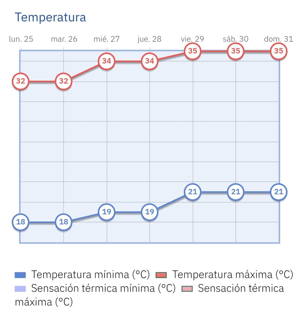
🧊 La jornada ha comenzado con temperaturas frescas, aunque los termómetros han ascendido rápidamente hasta rozar los 21 ºC en el centro de #Madrid. ☀️
📈 Mañana comenzará un ascenso térmico progresivo, con valores que podrían superar los 30 ºC a finales de la próxima semana.
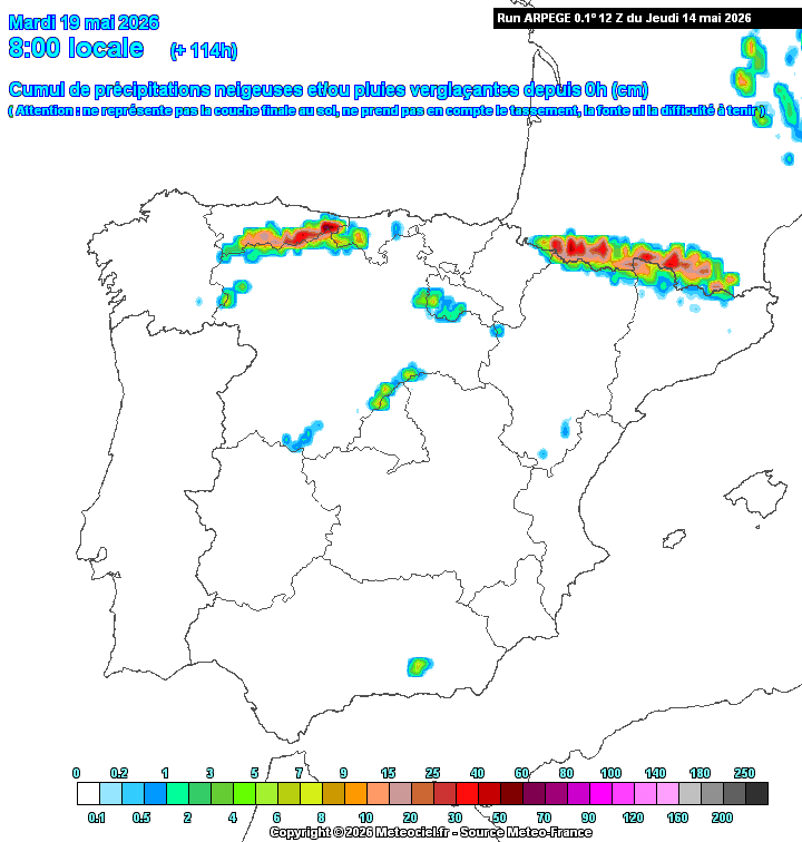
❄️ Mañana regresará el ambiente invernal, con nevadas que volverán a ganar protagonismo en los principales sistemas montañosos.
🏔️ En la Comunidad de #Madrid, la cota de nieve se situará en torno a los 1.600 metros, con chubascos dispersos en el resto de la región. 🌦️
#Mayo2026
@elrevelador26 Queda mucho y en primavera las cosas pueden cambiar a pocos días vista, pero parece que a partir del 19 debería de mejorar la situación y las temperaturas subirán, aunque en los días 25/26 podría estar algo más nublado y caer alguna gota
⛈️ Las próximas 2 semanas seguirán siendo muy primaverales e inestables en la Comunidad de #Madrid, con tormentas frecuentes, chubascos irregulares y temperaturas suaves 🌡️
🌤️ A finales de #mayo podría llegar algo más de estabilidad y calor, aunque aún con riesgo de tormentas.