How would you rate the accuracy and practical usefulness of my long-range forecasts for Autumn 2025 and Winter 2026 so far?
(Rating Scale):
(5🌟) Excellent (Highly accurate & very useful)
(4🌟) Good (Mostly accurate & useful)
(3🌟) Moderate (Mixed performance)
(2🌟) Low accuracy (Limited usefulness )
(1🌟) Not useful / Missed expectations
Your feedback helps refine future outlooks and improve regional targeting.
Please also mention your country/region in the comments so I can prioritize areas of highest relevance and usability .
Good morning, Pablo!
Maybe you are right! By checking the Zonal (westerly wind anomalies) for the current week via the reanalysis of likely analogs it appears that an upper level Easterly colder air may still exist above the conventional thickness ( 500-850 hpa) level, this colder air may , in some occasions, descend downward causing slightly colder easterly wind gusts ( blue anomalies= easterly wind or negative westerly in the wind map ) that do Not last for long periods-despite the presence of an Azores high or African Sahara surface high pressure/wind from one stand point : Cold Air is heavier and denser than warm air .
How recurrent and intense this can materialize during the coming weeks will depend on the current season configuration rather the reanalysis in general. these maps look at the current period ( 4-11 June) .
#HeadsUp🌍📈 July 2026 Synoptic Outlook & Temperature Anomalies
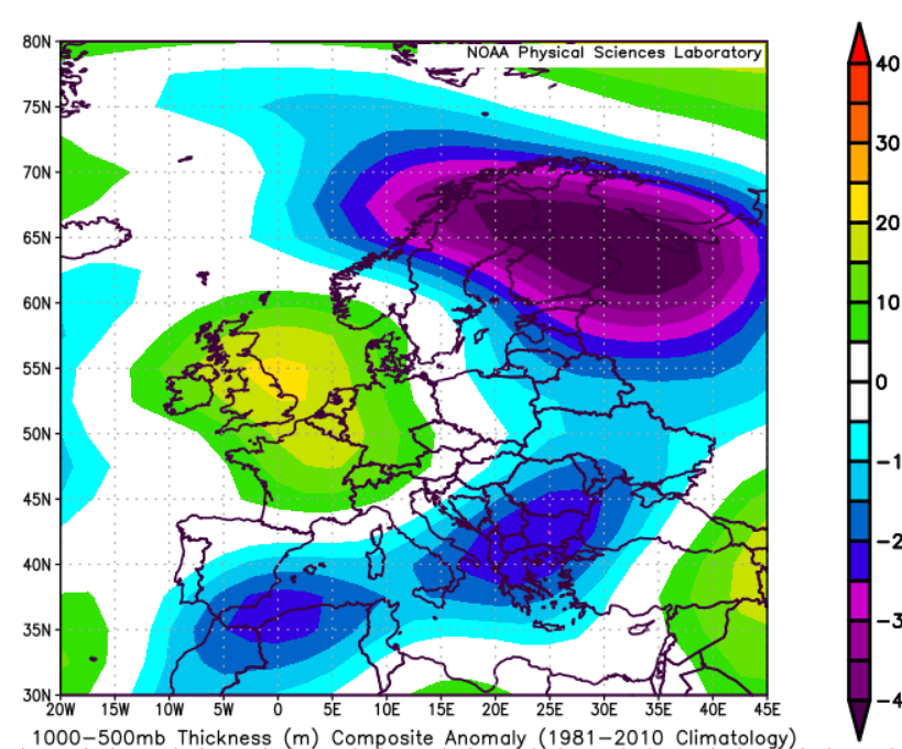
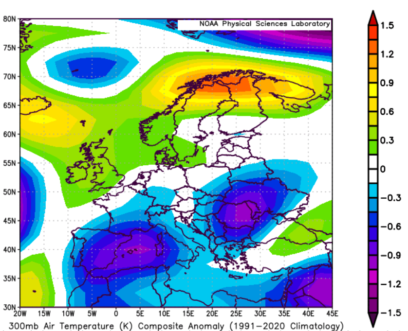
Based on 34 composite analog years and large-scale circulation analysis, July may evolve quite differently from the exceptional heat episodes observed across parts of Europe during late spring and early summer.
The dominant signal points toward a mildly positive NAO, combined with a positive Scandinavian pattern (+SCAND) and a tendency for higher pressure across northeastern Europe and the Ural region. At the same time, the North Atlantic storm track appears more active than normal, extending toward the British Isles, western Europe, and occasionally into southwestern Europe and the central Mediterranean.
🌡️ Temperature Outlook
• 🇪🇸🇵🇹#Iberia: Near-normal to slightly below normal temperatures overall, especially compared with late May and parts of June.
• #France 🇫🇷: Cooler tendencies over many regions, particularly western and central sectors.
• Italy & Central Mediterranean: Generally near to slightly below seasonal averages.
• North #Africa and Morocco mediterranean shores may feel milder conditions but inlands remain super exposed to desert heat. The African West Jetstream may move northward with possible rainfall and flood events in the Sahara countries.
• #Balkans & Anatolia: Modest cooling signal in several areas Greece, Bosnia, Eastern Alps .
• Southern #Italy 🇮🇹 and central mediterranean may experience persistent heat throughout the month. Bosnia and Greece may still get Northern cold air intrusions during periods of the month.
• #Levant , Iraq & northern Arabian Peninsula: Temperatures may remain seasonally warm but with fewer persistent extreme heat episodes than typically expected under strong subtropical ridging.
• Northeastern #Europe and areas closer to the Urals may experience relatively warmer conditions under the influence of persistent anticyclonic activity.
🌧️ Storm & Rainfall Pattern
A more active Atlantic circulation could support increased storm passages across western Europe, with periodic extensions into the central Mediterranean basin. This pattern may help limit the duration of heat events across parts of southern Europe while increasing opportunities for rainfall and convective activity. Rainfall pattern map notes are added in the comments.
🫸 Sum Up:
A flip in thermal pattern is expected during July, Northern Eastern Europe and Northern Balkans May experience warmer July month while western Europe is expected to experience milder conditions.
The warmer conditions over Western and SW Europe that was observed during Late May could be followed by warm June but Not as intense as late May, and July we may observe enhanced Atlantic storm track that may soften heat extent in Western Europe but causing warmer NE Europe and Urals. This does Not imply July would be cold, but rather milder for SW Europe and the Levant and parts of North Africa.
⚠️ This outlook is probabilistic and based on analog composites and synoptic-scale pattern recognition. Regional variations and shorter-lived heat episodes remain possible. Please Couple this forecast views with those yielded from the Numerical weather prediction models ( GFS, ECWMF, CMC..etc).
🫶🙏Kindly share the forecast ♻️♻️
Statistical Analog Modelling and Downscaling by Mohammad Alkhateeb (@Statisticizer)
🌍 https://t.co/4PftHqD0mL
#Heat_wave
#EuropeWeather #July2026 #LongRangeForecast #SynopticMeteorology #NAO #SCAND #WeatherForecast #Climate #Hodhodata #Statisticizer
How would you rate the accuracy and practical usefulness of my long-range forecasts for Autumn 2025 and Winter 2026 so far?
(Rating Scale):
(5🌟) Excellent (Highly accurate & very useful)
(4🌟) Good (Mostly accurate & useful)
(3🌟) Moderate (Mixed performance)
(2🌟) Low accuracy (Limited usefulness )
(1🌟) Not useful / Missed expectations
Your feedback helps refine future outlooks and improve regional targeting.
Please also mention your country/region in the comments so I can prioritize areas of highest relevance and usability .
The 74 year harmonic is probably related to the full length of the dataset. When the AMO is explored using Fast Fourier Transform (FFT) methods, or even Hilbert–Huang analyses, only a few periodicities tend to emerge around the 74-year cycle, and this feature is often linked to the length of the time series rather than a robust underlying oscillation.
In general, my analyses agree that the AMO could show gradual cooling over the coming decade, at least from a statistical standpoint.
"https://t.co/z38p6fJQHa" (https://t.co/z38p6fJQHa)
https://t.co/z38p6fJQHa https://t.co/z38p6fJQHa
I genuinely appreciate failed forecasts more than successful ones. They often teach me far more by exposing weaknesses in the analysis and revealing factors I may have missed.
I especially appreciate when people remind me of long-range forecasts that did not verify, as those cases provide some of the best opportunities for me to learn and improve.
@Enzo3038353980 I actually hope this forecast proves wrong. I often learn much more from failed forecasts than from successful ones, as they reveal gaps in my reasoning and help improve future analyses. Thanks for the advice!
@Enzo3038353980@ROrage09 The June forecast is materializing, heat may persist during June for France and southern Europe in general with some periodic breaks.
👇
🌍📊 June Synoptic Outlook & Temperature Signals (Analog Composite)
A dynamically active Rossby wave regime is favored into June, following the omega-blocking pattern observed over North America in May.
🔷 Synoptic Pattern
Amplified, wavy jet stream
Persistent Greenland ridge (positive anomalies)
Downstream Atlantic troughing & Scandinavian disturbance
Tendency toward split-flow / multi-trough configurations
👉 This is not a stable summer pattern, but a wave-driven regime
🌡️ 2m Temperature Outlook (Probabilistic)
🇪🇺 Europe
Neutral to slightly warm overall
Cooler anomalies over Scandinavia / NE Europe
Increased variability across Central Europe
Mediterranean prone to instability & transient lows
🇪🇸🇵🇹 SW Europe / Iberian Peninsula
Suppressed early-summer heat risk
Higher probability of Atlantic influence intrusions
Potential for:✔ intermittent cooling episodes
✔ cloudiness / unsettled conditions
Heat likely delayed or non-persistent
👉 Consistent with nearby Atlantic trough positioning
🇺🇸🇨🇦 North America
Mixed signals
Cool pockets central / western regions
Warmer anomalies toward NE Canada / Greenland sector
Continued influence from wave amplification
🇱🇧🇯🇴🇸🇾 Levant / Eastern Med
Near-normal to slightly warm
Not a persistent heat regime
Occasional intrusions from northern troughs
Potential for localized instability events
🔷 Greenland Signal (Key)
Strong positive Z500 anomalies
Acts as a blocking ridge anchor
Forces downstream wave amplification across the Atlantic–Europe sector
👉 This is a driver of the entire pattern
⚠️ Takeaway
June likely evolves under:
high-amplitude Rossby wave activity, not zonal summer flow
Expect:
variability /volatility in weather.
regional contrasts in 2-meter temperatures
episodic intrusions rather than sustained heat
The analysis had utilized 23 statistical analogs for current season, considering the ENSO latent growth, GLAAM, Blocking indexes and many other atmospheric and ocean SST indexes. The analysis is probabilistic Not deterministic, couple this view with numerical weather prediction models views for better prognostic analysis on weekly basis.
Statistical Model by Mr. M the chief data scientist @ https://t.co/4PftHqD0mL / @Statisticizer .
#Synoptic #WeatherPatterns #AnalogForecast #RossbyWaves #EuropeWeather #ClimateSignals
@Enzo3038353980 I actually hope this forecast proves wrong. I often learn much more from failed forecasts than from successful ones, as they reveal gaps in my reasoning and help improve future analyses. Thanks for the advice!
@Enzo3038353980 The only thing we can do at the meantime is just wait and see how things will evolve .
I have double checked my analyses using strictier analogs and the same pattern emerged.
Let us wait and see.
Those easterly gusts, occurring between roughly 2 PM and 6 PM and separated by periods of stagnant air, have been observed on my side of the Mediterranean for the past four days. They arrive suddenly, bringing noticeably cooler air, but rarely persist for more than 4–5 hours before giving way to light westerly winds.
Evidence is the cumulative (relevant) science,
Evidence is the cumulative body of relevant scientific knowledge that has been developed over time to explain a particular phenomenon. Relevance arises from multiple dimensions, including empirical and experimental support, practical applicability, theoretical coherence, usefulness, meaningfulness, and logical consistency. Together, these elements form the foundation upon which experts and the broader scientific community evaluate, refine, and strengthen our understanding of the natural and social world.
Good evening, Pablo!
From the proposed configuration, the pattern looks more supportive of a westerly or northwesterly synoptic influence over parts of North Africa, rather than a persistent synoptic-scale northeasterly regime.
That said, localized or mesoscale northeasterly breezes may still occur along coastal zones, especially where land–sea thermal contrasts and local pressure gradients are favorable.
However, for a sustained regional northeasterly event, we would usually need a more clearly established pressure gradient between higher pressure over Europe/western Mediterranean and lower pressure farther south.
Summer cooling episodes linked to Walker-type or mesoscale circulation anomalies can occur, but they are usually limited and not necessarily dominant at the synoptic scale. Strong volcanic forcing can sometimes enhance unusual cold summer patterns, but since no major explosive volcanic signal has occurred over the past year, I would be cautious about attributing the July setup to volcanic imprint, except perhaps very weak/secondary influence from the Ethiopian volcanic eruption later last autumn (Hayli Gubbi) .
So, my current expectation is: mostly westerly/northwesterly synoptic flow, with possible localized northeasterly coastal breezes rather than a persistent broad northeasterly regime. I will check the wind anomalies and 850 hpa Temperatures soon and let you know.