Power outages have sky rocketed for BGE customers since this second wave of storms tonight.
As of 10PM: more than 14,000 customers are without power.
We'll have the latest tonight on @wjz at 11..
Storm Damage Path
Microburst or brief touchdown?
From Doug Via
📝 Report I’m submitting to NWS
Local Storm Damage Report (Eyewitness)
Location: Private residence: Olde Oak Drive in Mount Airy, MD
Date: March 16, 2026
Event Time: Between 11:42 AM and 12:30 PM (estimated because power was out while witness was away)
‼️ 🌪️ During tornado warning
Witness Description:
• Storm moved through very quickly with intense winds and very cold rain.
• Damage path appears linear across the property.
Damage Observed:
• Debris path begins across the street with a snapped ~12-inch limb.
• Wind then struck a 27-foot camper, ripping the protective cover completely off despite four straps securing it underneath.
• Four trees were laid over near the camper.
• A ~16-inch diameter tree snapped farther along the path.
• Two additional trees were snapped approximately 25 feet apart farther back in the wooded area.
Additional Notes:
• Snapped trees appear somewhat spread out, while the downed trees are clustered together.
• Storm was described as very intense but brief.
Preliminary Considerations:
Damage pattern may be consistent with either:
• Localized microburst / intense straight-line winds, or
• Brief tornado touchdown
Further assessment of tree fall direction and convergence/divergence patterns would help determine the cause.
@NWS_BaltWash@MarylandEMA@TonyPannWBAL@ttasselWBAL@AvaWBAL
🦀MD Weather: Crab Cake Edition!🦀
👀WATCH: Crabs and seasoning are on the counter. Ingredients are ready, but nothing has formed.
✅Action: Stay alert!
🚨WARNING: The crab cake is being served NOW.
✅Action: Seek shelter! It’s happening.
Stay safe! #MDReady 🌩️🦀
11:47am-An initial round of severe/tornado warned storms continues to push east toward the I-95 metros in the next 1-2 hrs. Expect gusts 50-70 mph along this line along w/ embedded tornadoes. There should be a lull w/ more storms this aft-eve as the cold front pushes in.
Low clouds and passing showers are expected this morning. As these stratus clouds erode & a strong cold front approaches from the west, strong to severe t'storms are expected. The more potent cells could produce 70-80 mph wind gusts & even a few tornadoes. #MDwx#VAwx#DCwx#WVwx
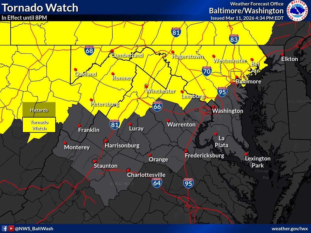
The Tornado Watch was expanded further east to include portions of Northern VA towards the Baltimore metro areas. The Watch remains in effect until 8 PM.
Road Stickage on I-70 in Frederick Co
🏔️ Elevation playing role.
📍Near Meyersville MD
Lower sun angle also allowing for cold temps to take its toll on pavement.
🙏 Please be careful as we approach the 6 PM sunset today.
📷 Jennifer Lucas Pond
@NWS_BaltWash@MarylandDOT@FCPSMaryland
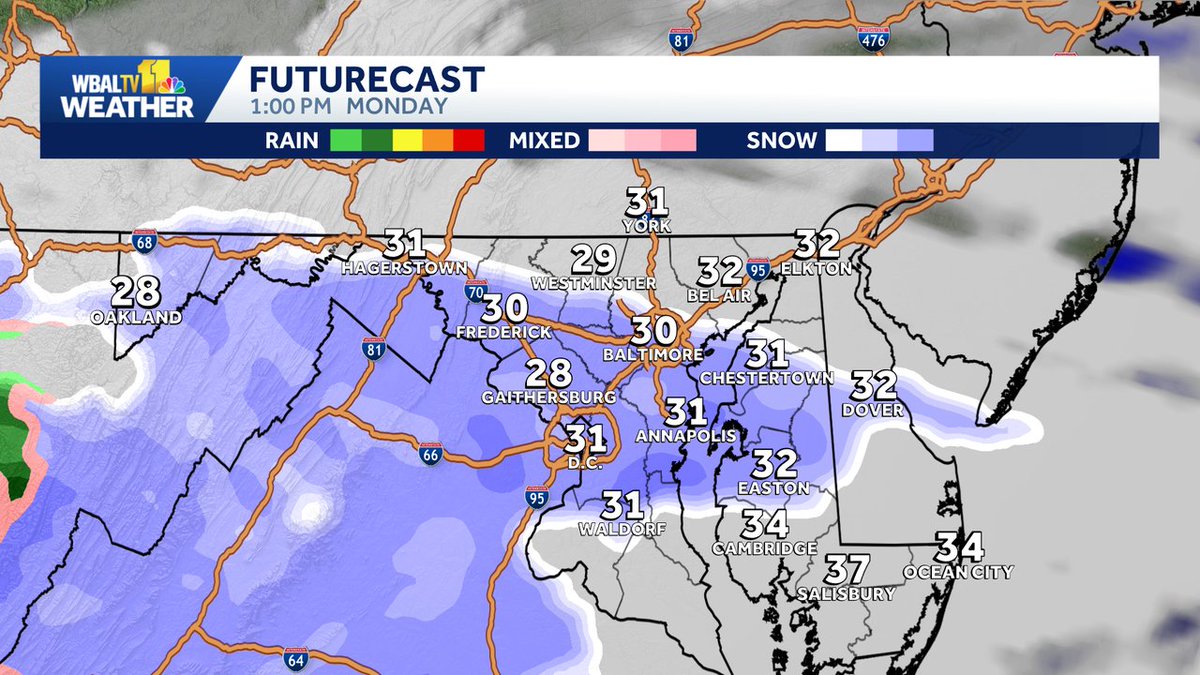
18z GRAF and HRRR now showing a little light snow for parts of the Baltimore Metro on Monday. Minor accumulations are possible in some areas. Light Freezing Rain (Ice) still possible early Tuesday Morning as well. Stay tuned... ❄️🚂