✈️🌏 Iniciamos nuestra vuelta al mundo en Japón, bajo los efectos del tifón Jangmi, ahora convertido en tormenta tropical. Sus efectos han llegado a Tokio, donde 700 vuelos han sido cancelados y las autoridades advierten del riesgo de desbordamiento del río Meguro. #AquílaTierra
This looks like something straight out of an apocalypse movie! Sometimes these dramatic shelf cloud formations can look like giant tsunami waves sweeping across the horizon. 🌊☁️
Another omega block will play a role in the upcoming early summer pattern. A strong high pressure system stuck in place will present drier risks in the midwest, with the active jet stream suppressed to the South. The general speed of the jet stream is heightened by El Nino, pushing that high slightly East versus letting it set up in the North Central US like past analog years.
Las olas de calor récord del mundo.
Según la NASA, hay “pruebas inequívocas de que la Tierra se está calentando a un ritmo sin precedentes”. Los datos de Copérnico, el programa europeo de observación de la Tierra para la Agencia Espacial Europea...
https://t.co/xPjjFDY5jQ
For the nerds, a follow up to yesterday’s post. Yesterday I used raw SST anomalies to compare El Niños. That’s a good way to illustrate the absolute strength of El Niños but it doesn’t take into account global warming, and how much easier it is today to achieve ludicrous SST anomalies. So today I used something called the rONI (relative Nino index) which takes into account both the state of the tropical oceans during that year’s El Niño and also the baseline climate average during that time. In this way the rONI tells us how warm the 3.4 region is now compared to the rest of the tropical oceans and with climate change accounted for. The result is: 2026 still leads the pack, but only by a hair. And of course this 2026 is only a forecast, it may not pan out. Still it shows the 2026 is forecast to be among the El Niño giants. Now you may ask why we need to calculate “relative”? Great question. Because the impacts of an El Niño rely more on how “relatively warm” the El Niño region is compared to the rest of the tropical oceans. If the rest of the tropics are cool, then the El Niño will over perform, dominating, and causing more extreme impacts/ changes to the climate. But if the rest of the tropics are also warm (2023) than the impacts of the El Niño will be muted.
Thanks to Brian McNoldy and Zeke Hausfather for their great data! Lastly, this year’s forecast from Zeke is the multimodel ensemble median of the dynamical models (not statistical) so it will not match the IRI (Columbia U) and Zeke’s method is updated as of the latest models, there’s no lag.
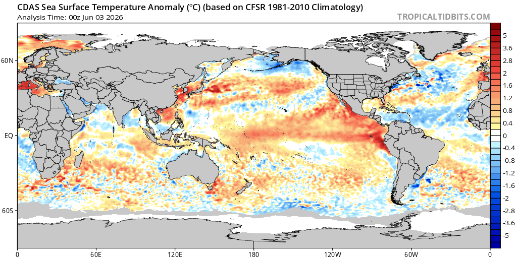
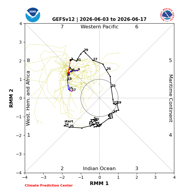
The Madden-Julian Oscillation (MJO) will continue to enhance westerly wind anomalies in the central & eastern equatorial #Pacific through mid-month. The westerlies will continue to aide warming of SSTs in these areas & favoring #ElNino being declared in June.
The historic May #Europe#heatwave has propelled Mediterranean temperatures into record territory with spots up to 6°C/ 11°F above normal with an ongoing Marine heatwave underway… 1/
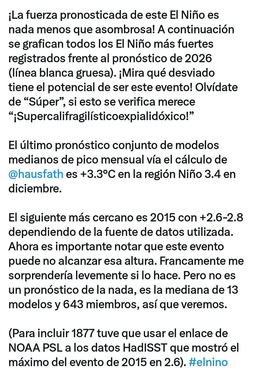
The forecast strength of this El Niño is nothing short of astonishing! Plotted below are all the strongest El Nino’s on record vs the 2026 forecast (thick white line). Look at how deviant this event has the “potential” to be! Forget “Super”, if this verifies it deserves “Supercalifragilistic expialidocious!”
The latest median model ensemble forecast monthly peak via @hausfath calculation is +3.3°C in the Nino 3.4 region in December.
The next closest is 2015 at +2.6-2.8 depending on data source used. Now it’s important to note that this event may not reach that height. Frankly I’d be mildly surprised if it does. But it’s not a forecast out of thin air, it’s the median of 13 models and 643 members, so we’ll see.
(To include 1877 I had to use NOAA PSL link to HadISST data which showed the 2015 event max at 2.6). #elnino
NEW: First NHC cone of the season is out for the Eastern Pacific as TD #1 forms in open waters. First name is #Amanda, which it is projected to become. No threat to land. The tropics still remain quiet in the Atlantic.
Red sprites reportedly spotted over Tibet
These mysterious flashes appear high above thunderstorms and last only milliseconds, making them extremely difficult to film
La más reciente actualización @WMO indica que existe un 80% de probabilidad de que se desarrolle un evento El Niño entre junio y agosto de 2026. Es fundamental mantenerse informado a través de las fuentes oficiales de cada país.