See something you think others might be interested in or need to know? #Retweet!
Interested yourself or glad to know? Leave a #Like!
Thank you and have an amazing day.
Expect a mostly sunny, dry, and hot week ahead. Daily highs will climb from the mid-90s into the low 100s, while breezy south winds bring gusts up to 30 mph. The real story is the heat index, which will remain elevated and get as 107°F by the weekend. Stay safe and hydrated!
Hot, breezy, and hazy today! ☀️💨 Morning clouds will clear quickly as haze rolls in from the Gulf this afternoon. Expect highs up to 102°F and heat index values climbing as high as 105°F across South Central Texas. Stay hydrated and practice heat safety!
Austin drivers can expect disruptions for multiple weekends, starting Friday night, as the Texas Department of Transportation moves forward with construction on Interstate 35. https://t.co/fEE5DTxx5H
Hot, breezy & mostly sunny conditions are expected this afternoon. Highs will be in the 90s with heat indices up to around 105 degrees. Southerly wind increases mid to late morning with gusts up to 25 mph. The forecast remains relatively unchanged heading into early next week.
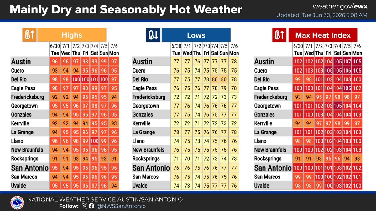
A 7-day outlook for South-Central Texas shows a "Seasonably Hot" week with zero rain forecast from June 25 to July 1, 2026. High temperatures will consistently reach the mid-to-upper 90s, driving maximum heat index values into values as high as 106°F across major regional cities.
The next several days likely will be warmer than our average late-June afternoon temperatures of 94 and morning temps at 74 degrees. https://t.co/bIXffLN4ou
Learn the stories behind the city's most recognizable street names. Use our interactive map to hover over any major road and see who or what is behind it. https://t.co/XuQP5LYkQ8
After a legal challenge, the city of Austin can move forward with a plan to help fund the expansion of the Austin Convention Center. https://t.co/2pVfvwIxfL
Austin ISD's board voted to reduce its budget by $205 million for next school year but, in a last minute change, each campus will keep a librarian. https://t.co/R4THAsY7Mr
A new UT Austin study found several water samples collected in far East Austin exceeded regulatory guidelines for lead and other heavy metals. https://t.co/WZQlctKOFQ
Starting this weekend, Major to Extreme HeatRisk will begin spreading into the Midwest, Deep South, and southwestern U.S. As blistering as the daytime highs will be in many areas, record-warm morning lows will heighten the danger for those unable to seek cool shelter. Ensure your loved ones and neighbors stay safe from the heat, and remain #WeatherReady.
Look for morning clouds clear by midday, leading to an entirely dry, hot week. Daily highs range from the 90s to low 100s, driving dangerous maximum heat index values up to 107°F or 108°F.
South-Central Texas is locked into a hot and humid weather pattern. Expect partly cloudy skies with highs climbing from the 90s into triple digits by the weekend. Heat index values will near 110 with virtually zero chance of rain. Stay hydrated and practice heat safety!
An intense, humid heatwave impacts the region, triggering Heat Advisories today with peak heat indices between 102°F and 112°F. While scattered storms bring localized rain chances up to 65% through Saturday, dry weather returns quickly by Sunday.
Austin's heat index just hit 117 degrees for the first time in years, creating a dangerous combination of high temperatures and humidity. https://t.co/Zw8ArQGMc5
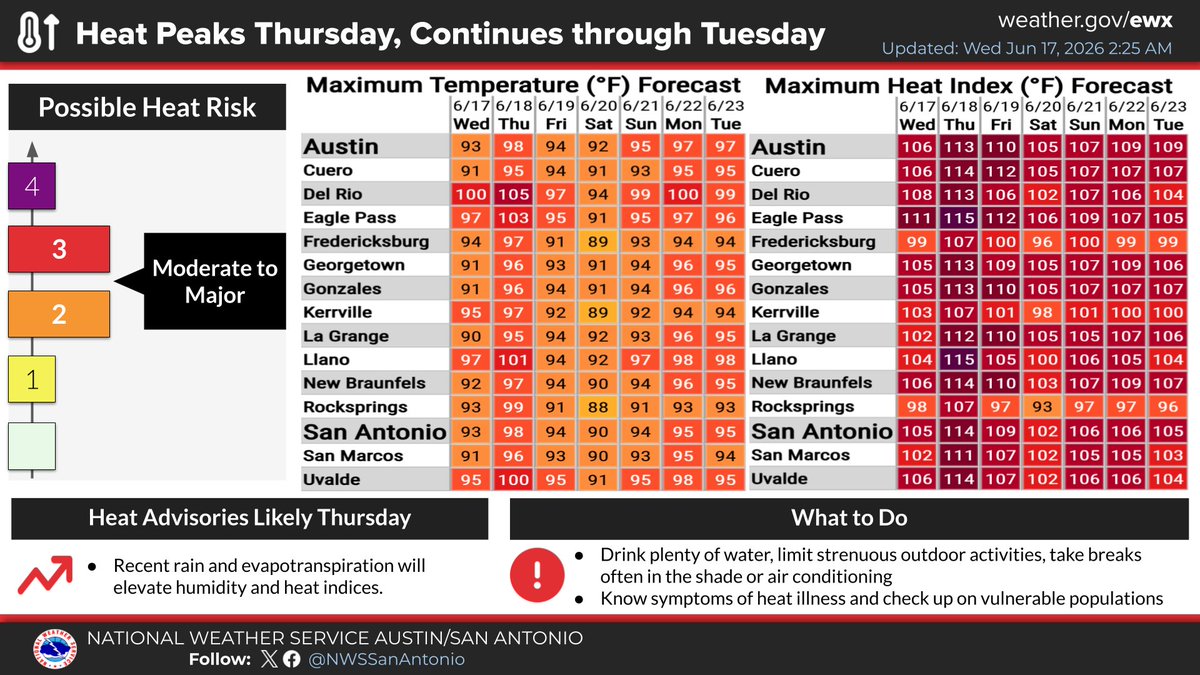
Extreme heat peaks today and continues into next week. Highs will range from 95F to 109F, with heat indices pushing up to 116F. Stay safe by drinking plenty of water, limiting outdoor activities, taking breaks in the shade or AC, and checking on vulnerable populations.
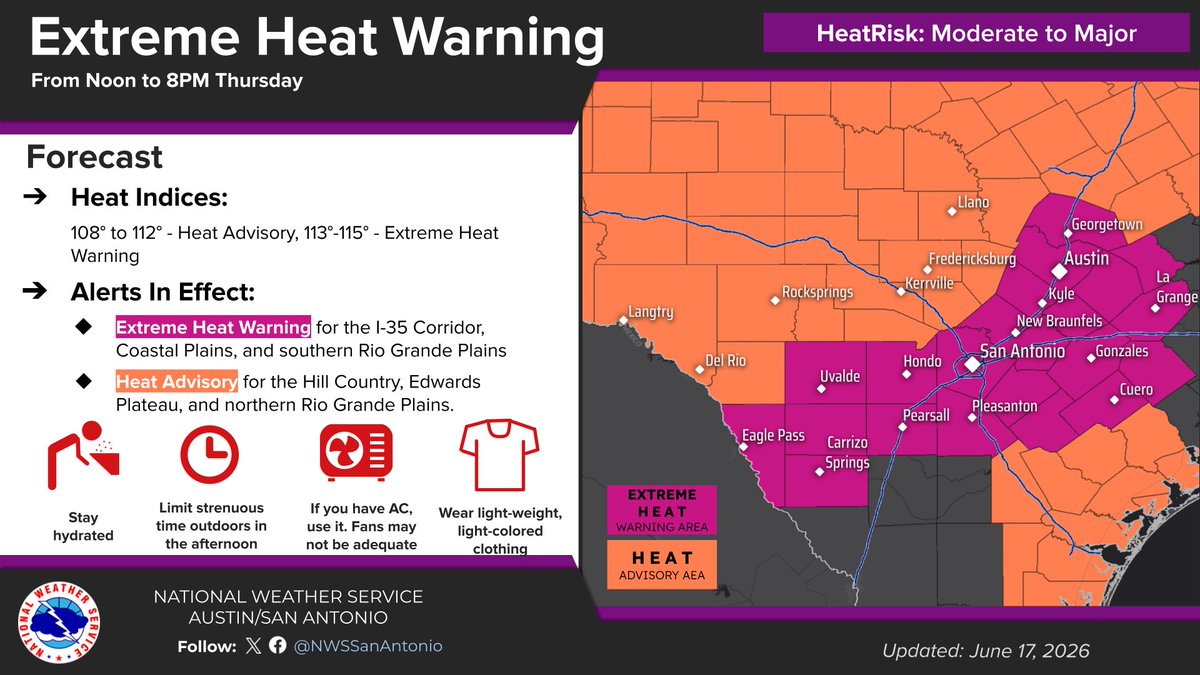
An Extreme Heat Warning and Heat Advisory are in effect Thursday from noon to 8 PM. Heat indices will climb as high as 115 degrees. Please stay hydrated, limit outdoor activities, and check on vulnerable neighbors. Stay safe. Summer heat continues into the weekend.