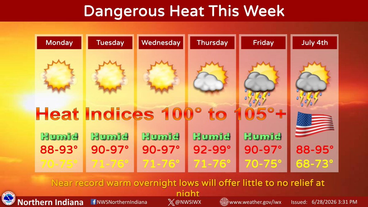
An Extreme Heat Warning is in effect Monday afternoon through Thursday evening. Highs in the 90s and afternoon heat indices of 100° to around 105° will be hazardous. Never leave people or pets in the car; look before you lock! #INwx#MIwx#OHwx
4pm EDT: Cloudy and rainy this hour, but we continue to see evidence that we’re not out of the woods yet. A variety of model guidance continue to suggest that we will have time “recover” and that severe storms remain possible. Remain weather aware this evening. #inwx#miwx#ohwx
As our office continues to monitor the potential for severe weather today and tonight, it's always good to remind everyone to have multiple ways to receive severe weather alerts.
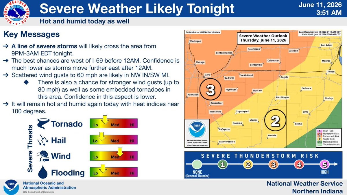
Severe weather is possible across much of Indiana this afternoon and into the overnight hours, with damaging wind gusts, large hail and tornadoes all possible.
Learn more about tornado and severe weather safety at https://t.co/irR88gjIEC.
#INwx#SevereWeather#TornadoSafety
Wednesday's Severe Weather Risk-two rounds, one from 10am-5pm ET/another from 5pm-2am ET. Greatest risk will be with round 2. Medium/high confidence. Damaging winds, large hail, tornadoes, and flooding are all threats, especially in the enhanced/moderate risk areas (Levels 3-4)
For Wednesday, the Enhanced Risk area of severe thunderstorms was expanded. This means that numerous severe storms are possible. We'll be closely monitoring any storms earlier in the day and how that impacts the late-day severe storms chances. Be weather aware! #inwx#ohwx#miwx
Severe weather is possible today with damaging wind and a few tornadoes as the main threats. Make sure to have multiple ways to receive warning information and a way to be woken up by these notifications at night.
A heat advisory is also in place today for 100 degree heat indices
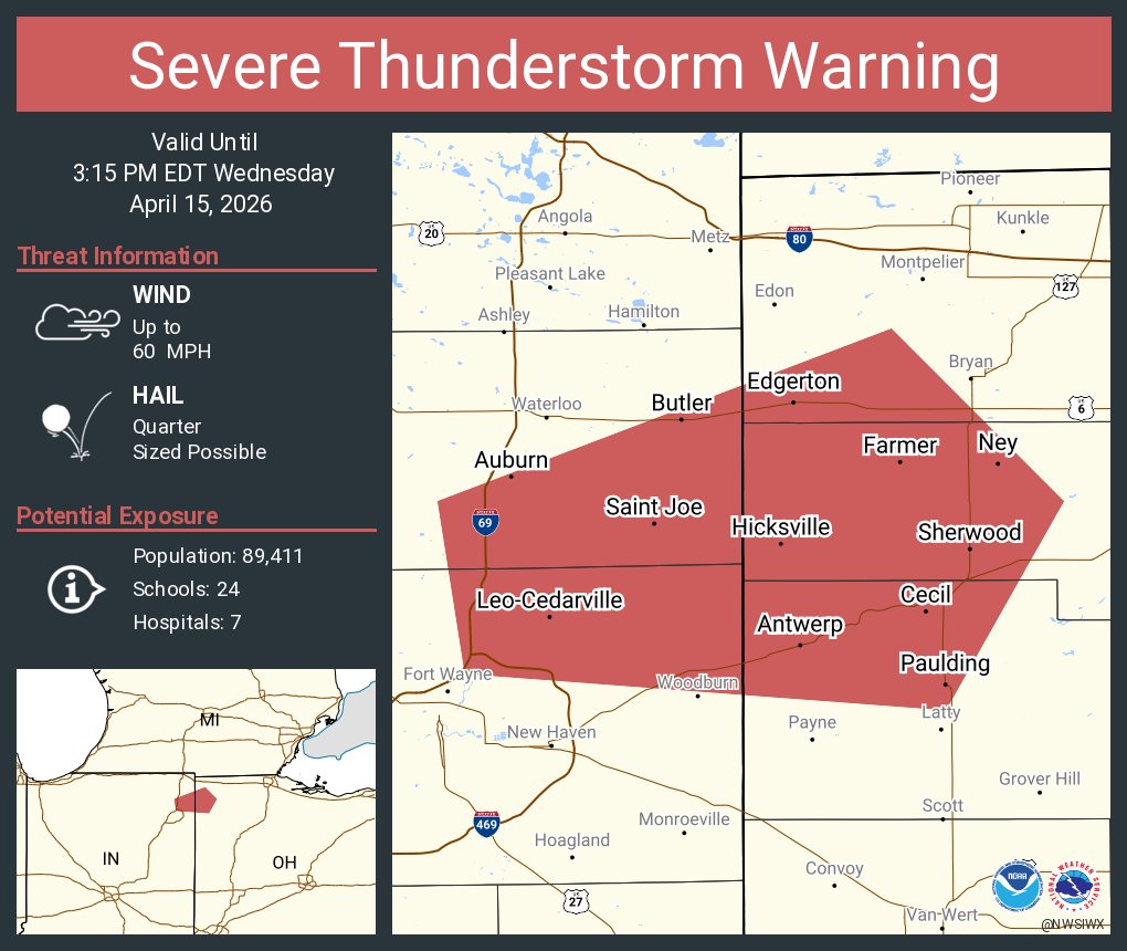
A slight risk for severe weather is in place for this evening into tonight. The main threat is expected to be damaging wind and hail, but a tornado cannot be ruled out. Heavy rain could lead to ponding of water on the roads, and flooding concerns later tonight.
Rain showers tonight and cool. Colder this weekend with frosty starts to the morning on Saturday and Sunday. On Saturday morning some isolated freeze conditions possible especially in low lying areas. Protect your plants, pets, and livestock from the cold. #MIwx#INwx#OHwx
Scattered showers will diminish later this evening east of Interstate 69. Otherwise, cool conditions ahead with frost and freeze conditions likely Friday night, and then again Saturday night. A low chance of showers returns Friday south of US Route 24 across NE IN/NW OH.
Best chances for severe weather Monday occur during the evening, but remain contingent on a possible first round of likely weaker storms earlier in the day. All severe threats are possible although hail may have a lower chance of occurring.
A strong cold front will bring thunderstorms tonight, followed by breezy winds, and cooler conditions for this weekend. Frost will be possible Saturday night and again Sunday night. Plans should be made to protect cold-sensistive plants. Warmer weather will return mid-week.
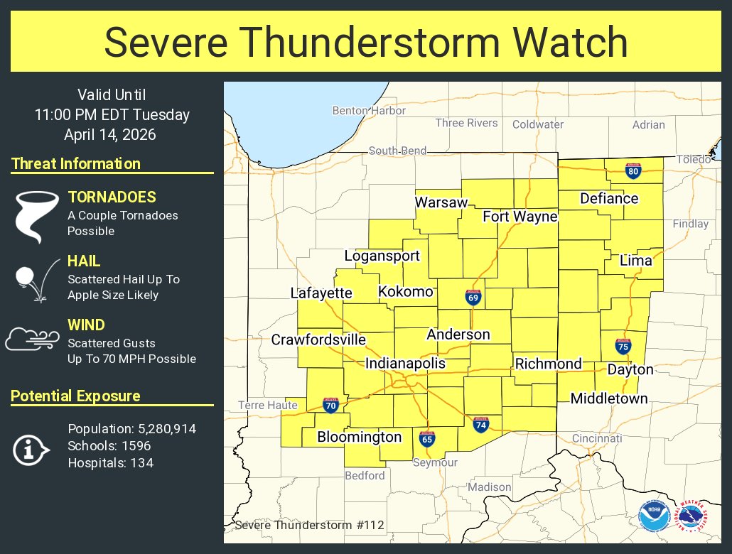
A tornado watch has been issued for the area. The time period where storms look to move through is between 11pm and 3am ET. An extension of the watch into NW OH is possible as well.
After one more freezing night ahead, temperatures trend warmer into the 50s and 60s for highs over the next several days. A few locations could get into the low 70s on Thursday. Rain and storms return on Thursday and Friday but severe weather is NOT expected at this time.
While some passing showers are possible tonight and perhaps on Monday, they’re light enough to not add to current flooding. Dry, especially for Tuesday, but also, cool. Consider taking steps to protect cold-sensitive plants with early Tuesday AM temps in the 20s.