We finished our first ever SWRCC newsletter! Click the link to learn all about our center and what we've been up to these past 2 years! https://t.co/FWnSUeOYFU
Flooding in southern #Queens and southern #Brooklyn last night was caused by heavy rainfall, with portions of this area experiencing over 2" in one hour. The sewer capacity is generally 1.5-1.75"/h in this area.
Some locations reported as much as .5" of rain in just 5 minutes!
Severe thunderstorms with heavy rain is likely producing flooding in portions of #NYC including southern Brooklyn and/or Queens. @nysmesonet rainfall observations indicate rainfall as high as 2.06" has been observed in 1 hour, with numerous areas exceeding local sewer capacity.
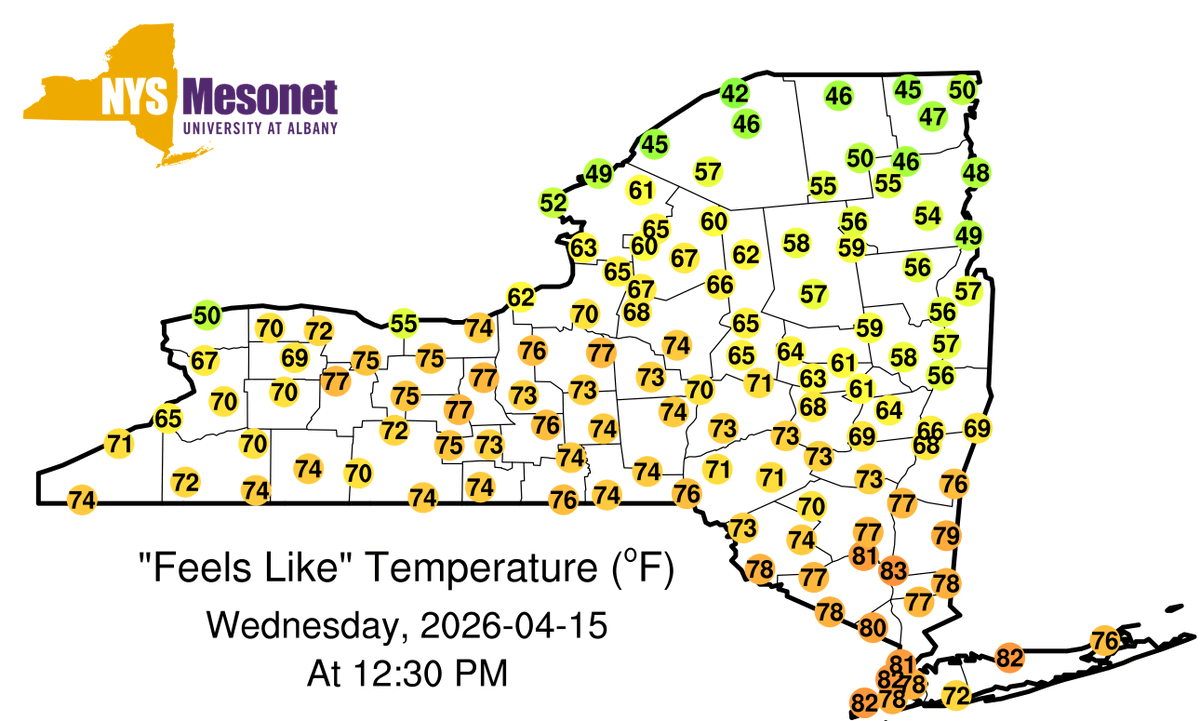
Mid-summer heat has made an early appearance in #NYC, with temperatures in Staten Island, Manhattan, the Bronx, and portions of Brooklyn/Queens in the mid-90s. For some along the south shores of Brooklyn/Queens, a seabreeze is keeping temperatures more comfortable. #nycwx
Today marks the first day of 2026 that a @nysmesonet site has reached >= 90F, and tomorrow looks just as warm. Approximately 1/3 NYers are under a "Major" risk-level in the NWS HeatRisk product. Early season heat often feels worse because our bodies have not yet acclimated to it.
About 3.5 million people are under a Severe Thunderstorm Watch through 10PM this evening. Current radar shows a line of storms moving west to east across the state. Storms may reduce visibility, contain lightning, hail, and/or damaging wind gusts.
@therobdale To our knowledge, there has been no such research on that topic in NY. I suspect the sample size would be exceedingly low, such that statistically significant conclusions would be difficult. Still, sounds like a great project!
We estimate there are currently about ~5000 New Yorkers in the perilous position of being within a tornado warning and within a flash flood warning.
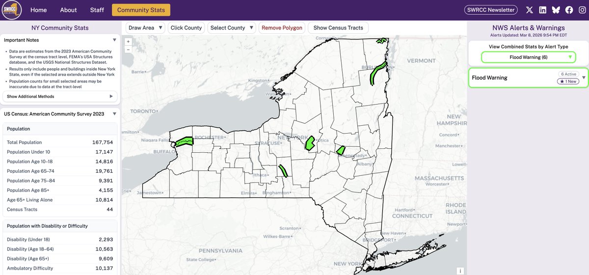
We calculate this using the community stats tool on our website, & selecting the polygon where both occur: https://t.co/rTouDy9in3
It's been busy lately! Here's a map of all @NWS-issued tornado, severe thunderstorm, and flood-themed warnings over the last day or so.
Also shown are hail, severe wind, and flood reports. Those may change as more reports or NWS surveys filter in. #nywx
@SnarkyEM We also use USA Structures and USGS National Structures datasets to extract non-population statistics as well! They're just off the screenshot, however.
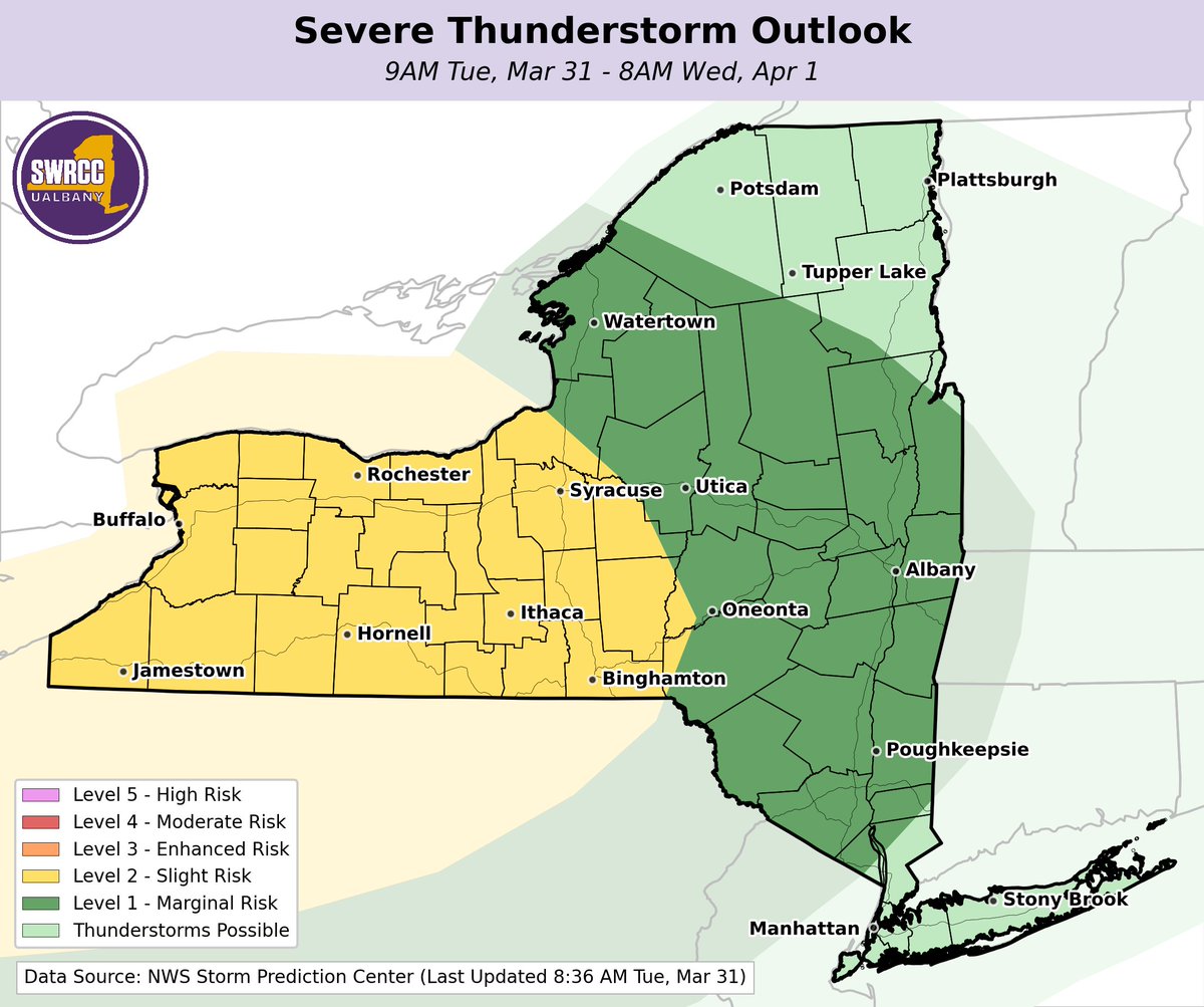
These two maps may look very similar, but they're highlighting two different hazards:
The map on the left shows the @NWS risk of severe thunderstorms today, which is highest in western/central NY. The right map shows the risk of flash flooding, also highest in western NY.
Rain is impacting the state today with isolated thunderstorms moving eastward across the state this afternoon & evening.
🌧️ Localized rain totals may reach 2.50–4”. Flash flooding is possible.
🧊 0.30” of isolated ice is possible in Northern NY.
🌬️ 30–45 mph winds are likely.
Happy first day of spring, New York! 🌷 Though it seemed like a brutally cold winter, it was actually only slightly below-average compared to a 30-years of data. While the end of March is forecasted to be below normal, a shift to above normal temperatures is possible in April. ☀️
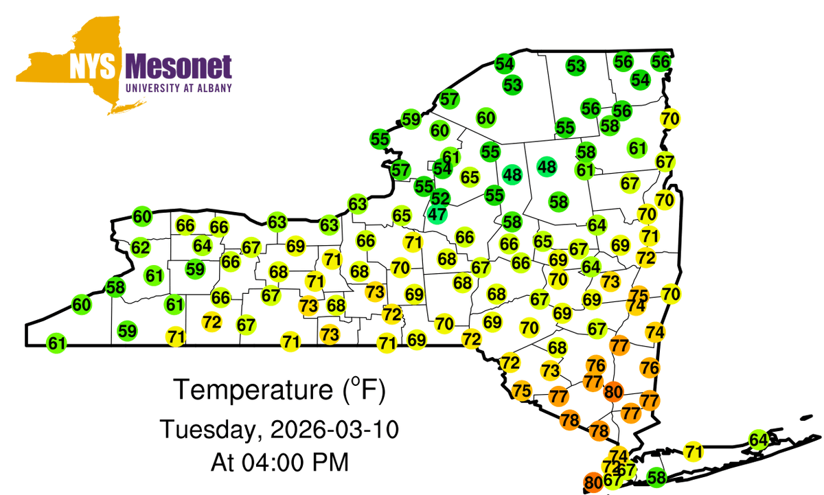
This afternoon, areas of NY saw 80F temperatures for the first time since last fall! The last 80F values across the @nysmesonet occurred on October 19th when Louisville reached 81F.
In #NYC, Central Park appears to have reached their earliest 80F+ high on record.
With melting snow and ice, alongside some rain and warming temperatures, we're seeing numerous river rises leading to some flooding.
Did you know our website has a community page (https://t.co/rTouDy9in3)?
There's ~168K people & ~63K residential buildings in a flood warning.
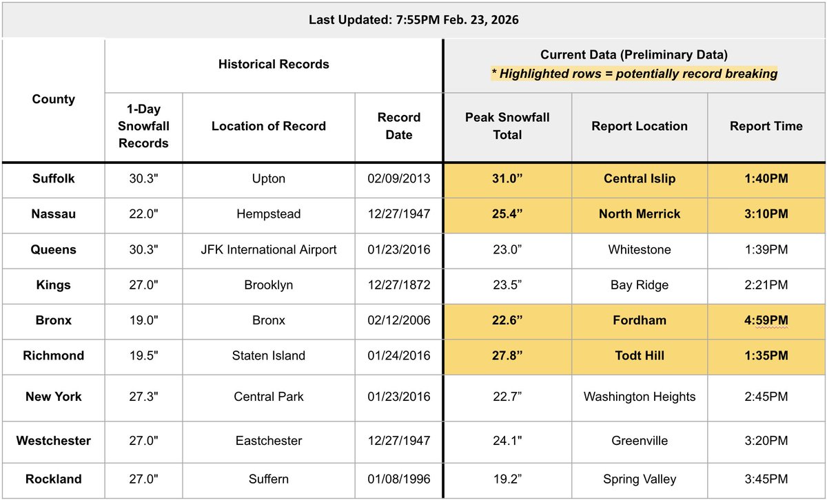
Wondering if the snowfall reports are record breaking? We got you!
For the hardest hit counties, here's a list of the prior 1-day record, as well as the max snowfall report in each county today.
4 (!) counties have tentatively set records, though they will be investigated.
The recent bout of snow and wind beguiling the East Coast fits all the definitions: It’s a nor’easter, blizzard and bomb cyclone wrapped up in one. ❄️ https://t.co/KM9PG3XV2v
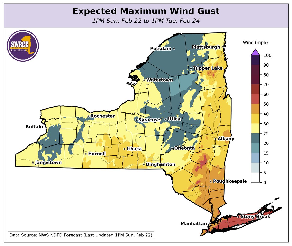
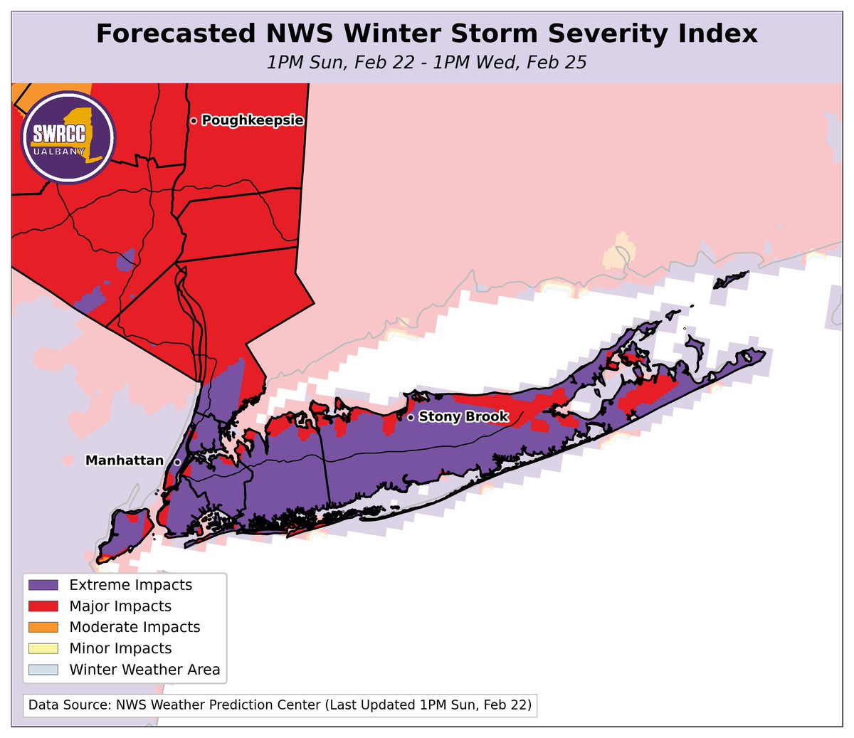
As we approach the onset of heavier snow, let's take stock of the forecast.
The most severe impacts are expected across downstate NY, where the Winter Storm Severity Index is at a very rare "extreme" level. This is due to a forecast of 18"+ of snow and 50+ mph wind gusts.


![NYSWRCC's tweet photo. [light-hearted post]
Similarly, many people ask us how to pronounce SWRCC. The answer is ... that there is no agreed-upon answer. https://t.co/KbdDdply9Z](https://pbs.twimg.com/media/HIsvk7MW8AABbbK.png)