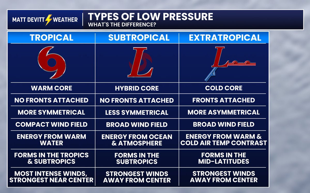
What’s the difference between a hurricane and nor’easter? The difference is a nor’easter has a cold core, is fueled by temperature differences and has fronts attached to it. Tropical systems have warm cores, no fronts and gets its energy from warm water.
The nor’easter lashing Nantucket with wind and rain this weekend has uncovered the remains of a shipwreck along the island’s south shore.
The fragment is likely from the 19th century schooner Warren Sawyer, a wooden ship that wrecked near Miacomet Beach on December 22, 1884.
Recon just flew into Hurricane Polo and found a pressure of 889.3 mb.
This is unbelievable. That makes Polo the SECOND STRONGEST EPAC HURRICANE EVER.
Official pressure awaiting dropsonde, but this is a historic, top-tier storm.
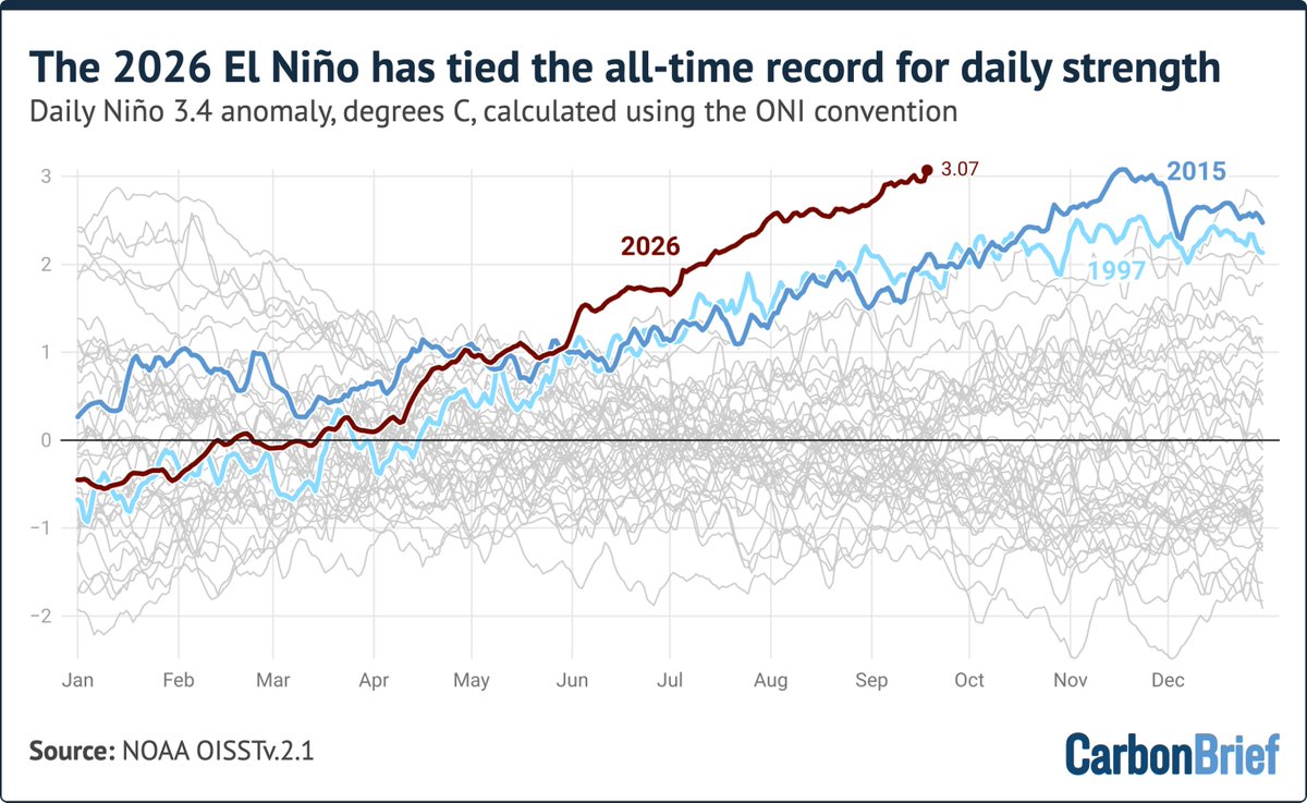
This year's El Niño event is moving into record territory, with the daily Oceanic Niño Index (ONI) tying the record previously set during the 2015/2016 super-El Niño. My latest over at Carbon Brief (link below).
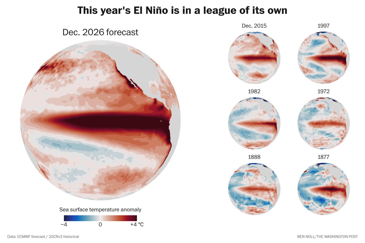
Here's what the peak of this year's El Niño will look like next to the six strongest events on record that came before it.
It's in a league of its own, beyond even the “super El Niño” category.
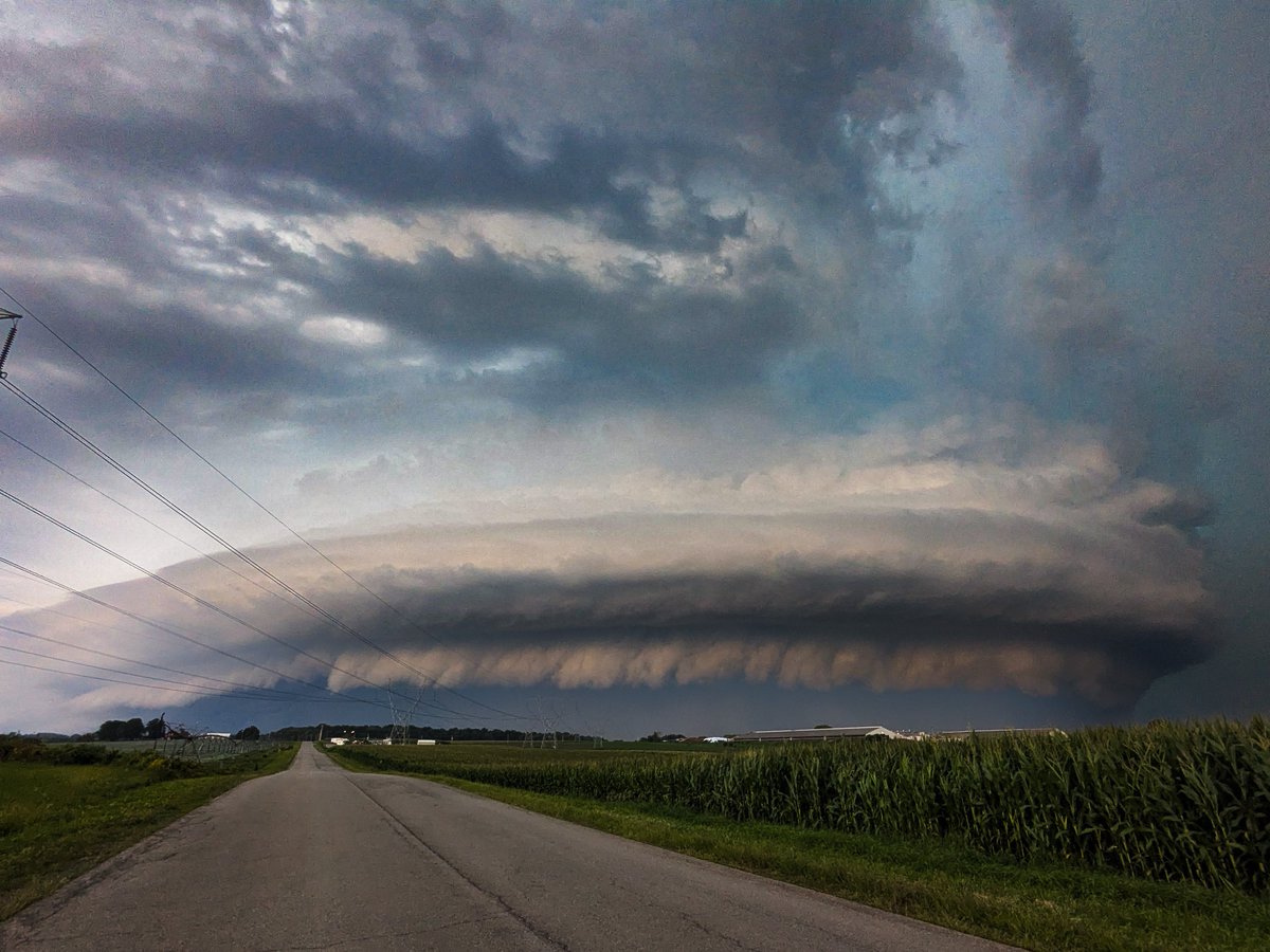
Some final edits on that outrageous mothership in Medina, NY.
Two tornadoes confirmed. I have learned that one tornado was ongoing two miles away in the 3rd photo, likely behind the corn on the right. I've tried to contrast enhance it but not seeing anything convincing. #nywx
We’ll have to wait for official confirmation. But preliminarily, Illinois has reached 242 tornadoes which would beat the all time US record of 241 set in Texas in 2015!
…with 4+ months to go. Despite being 4.6 times smaller in surface area. Maybe the wildest weather season ever
Some of the drought stricken areas in Park County above 10,000’ are showing some color already (beyond just drought stress). More to come. A few miles N of Fairplay, CO. @ExploreFall@FoliageReport@BianchiWeather
We've never seen an El Niño this strong with a -PDO this strong before in our dataset back through 1950. This unusual setup is fueling a hotter than expected summer but El Niño's high global wind anomaly is preventing heat ridges from locking long in any one place.
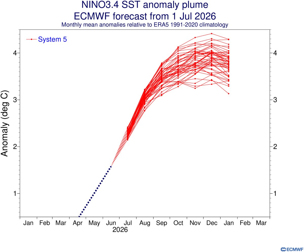
Breaking: El Niño intensity forecasts have trended stronger — again.
Every forecast scenario in the new ECMWF outlook shows the strongest El Niño on record this year, with ocean temperatures peaking 3.3˚C to 4.4˚C above average in the central equatorial Pacific in December.
WOW! A tornado occurred IN ALASKA Saturday.
This is near the Alpine Creek Lodge midway between Anchorage and Fairbanks. There are only six tornadoes on record in Alaska dating back to 1950.
And for the tornado to condense all the way to the ground!? Bonafide supercell.
June has featured record-breaking westerly wind bursts in the Pacific.
This is causing new Kelvin wave activity that will shift more warm water toward the eastern Pacific, probably culminating in the strongest El Niño on record this year — possibly by a wide margin.
I see some criticism of NWS Wichita for the unwarned fatal tornado last night, but I just wanted to offer some perspective to the difficulties that come with warning QLCS tornadoes, and how quickly this happened last night. See the 3 radar frames attached -- the destroyed manufactured home is marked with a small red square marker.
The first frame shows one of many circulations along the squall line that could potentially be tornadic. In the first frame at 06:11:55z some circulation along the leading edge is evident, but not well organized, especially compared to earlier ones or even the one to the southeast.
At 06:15:01z the velocity signature has become extremely well organized and suddenly has a debris signature. To issue a warning at this point, they would have had to see the TDS, draw out the warning -- oops, time's up, the manufactured home is already destroyed. Even if a warning is very quickly issued, there is a reaction time delay for receivers to take action IF they even have a way to receive the warning at 1:15 AM (and another huge factor is IF they even take action, which is quite a major problem in itself).
In my opinion, there is certainly some valid criticism with regard to being conservative with issuing warnings (but this is always a difficult balance between underwarning and overwarning, especially with tornadic QLCS events). I've seen some criticism for the SVR's not being tornado tagged, but personally I believe that changes absolutely nothing about outcomes at 1:20 in the morning. Overall I feel like this was genuinely just an extremely unfortunate sequence and a really hard one to have warned with any useful lead time.
YELLOW ALERT: Beware of flooded roads on your commute. Our photojournalist saw two cars stuck in floodwater on Elmgrove Road in Gates overnight. Tune into News10NBC's flood coverage now through 7 a.m.