June has featured record-breaking westerly wind bursts in the Pacific.
This is causing new Kelvin wave activity that will shift more warm water toward the eastern Pacific, probably culminating in the strongest El Niño on record this year — possibly by a wide margin.
I see some criticism of NWS Wichita for the unwarned fatal tornado last night, but I just wanted to offer some perspective to the difficulties that come with warning QLCS tornadoes, and how quickly this happened last night. See the 3 radar frames attached -- the destroyed manufactured home is marked with a small red square marker.
The first frame shows one of many circulations along the squall line that could potentially be tornadic. In the first frame at 06:11:55z some circulation along the leading edge is evident, but not well organized, especially compared to earlier ones or even the one to the southeast.
At 06:15:01z the velocity signature has become extremely well organized and suddenly has a debris signature. To issue a warning at this point, they would have had to see the TDS, draw out the warning -- oops, time's up, the manufactured home is already destroyed. Even if a warning is very quickly issued, there is a reaction time delay for receivers to take action IF they even have a way to receive the warning at 1:15 AM (and another huge factor is IF they even take action, which is quite a major problem in itself).
In my opinion, there is certainly some valid criticism with regard to being conservative with issuing warnings (but this is always a difficult balance between underwarning and overwarning, especially with tornadic QLCS events). I've seen some criticism for the SVR's not being tornado tagged, but personally I believe that changes absolutely nothing about outcomes at 1:20 in the morning. Overall I feel like this was genuinely just an extremely unfortunate sequence and a really hard one to have warned with any useful lead time.
YELLOW ALERT: Beware of flooded roads on your commute. Our photojournalist saw two cars stuck in floodwater on Elmgrove Road in Gates overnight. Tune into News10NBC's flood coverage now through 7 a.m.
Important update imo from NHC on watches and warnings inland now along with updates to many other things including marine warnings, website user interface and also how the cone will appear now to account for average track error.
Here’s the full breakdown from the NHC themselves on available changes coming this Hurricane season to the cone
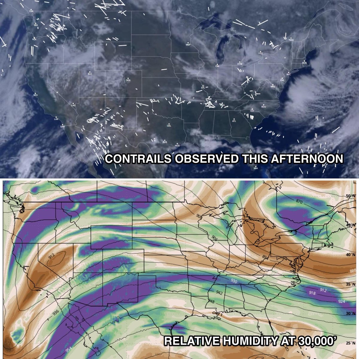
2 maps. One shows the contrails this afternoon. The other shows the relative humidity at roughly 30,000'.... contrails form when the atmospheric conditions are right.
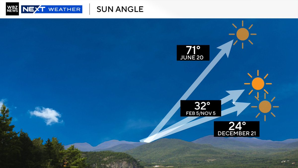
Today is the final day of solar winter, the darkest 3-month period of the year
By next week the sun angle is the same as October, which we affectionately call #SunAngleSzn
Brighter times ahead 😎
🚨Big Winter Update🚨
Cold February Bust?
I am monitoring, but recent guidance is backing off the idea of an extended deep Arctic spell continuing through February. The SSW may send the PV to the other side of the globe for the 2nd half of February. That would be our prime source for any true cold. We are starting to see a positive WPO which can also support warmth over the Eastern US, on the contrary a Negative NAO can be cold for us (both can have great power over our weather this time of year). EPO is losing its cold stance as well. All in all I am leaning higher on warmer risks to my initial idea of a sustained cold pattern bleeding into March. I am not 100% sold on a full blown blow-torch pattern, as cold shots and wintry weather are still possible given the MJO and some teleconnections. I will update again soon for any changes cold or warm.
RED ALERT: Snow has started falling in much of the region, including in downtown Rochester. By tomorrow, expect at least a foot of snow on the ground. Here are the latest details on the incoming winter storm: https://t.co/EC0OlKpn7f
@NWSBUFFALO@wxbywilliams#Weather#Phenomenal
Waking up on the west side of thousands of these natural created snow balls all over #Chili
We had the snow squall then some 30 MPH winds that caused this event. It’s pretty sight.
BREAKING: The aurora borealis may be visible from much of the central and northern United States either Monday night/Tuesday, January 19-20. Monday NIGHT late is the most likely time frame.
An X2-class solar flare launched off the sun around 11:09 a.m. Eastern time Sunday. It originated from sunspot 4341, a large, bruise-like discoloration on the surface of the sun throbbing and pulsating with magnetic energy. It's also a cooler region on the sun's surface.
Solar flares are flashes of light and electromagnetic radiation that expel high-energy particles through space at the speed of light. This particular flare caused a degradation of radio wave propagation and partial radio blackout over western South America and the eastern South Pacific.
It also appears a CME, or coronal mass ejection, accompanied the flare. CMEs are slower waves of magnetism and ejected solar plasma that surf through space like a shockwave. They take a couple days to reach Earth (when they’re Earth-directed). Stronger ones are usually faster.
CMEs interact with Earth’s magnetic field, which transforms potentially harmful energy and magnetism into visible light — the aurora.
It's probable that the CME will reach Earth sometime Monday or Tuesday. It should probably take on the order of 36 hours to get here; the rough ballpark speed is being analyzed currently.
If it hits during the daylight hours, the timing will be unfavorable for viewing the auroras. If it comes in Monday night or very early Tuesday before sunrise, the aurora may be visible in North America. The ideal scenario would be the magnetic shockwave hitting Earth's magnetic field sometime overnight Monday night. Around mignight may be optimal.
According to space weather forecaster and expert Vincent Ledvina, a good middle-of-the-road estimate for possible impacts are in the G2 to G3 range, or a moderate geomagnetic storm. That could spill the aurora over the northern U.S., with a glow visible farther south.
Isolated yourself from city lights and find a clear, unobstructed view of the northern horizon. Check the weather forecast first too... and stay tuned here for updates.
Also note that we do NOT HAVE A SPECIFIC TIME. Space weather forecasting is still in its infancy, and timing your observation with the occurrence of an auroral “substorm” is purely a game of luck.
Snow at the end of the week Thursday/Friday? Probably. Blockbuster snow at the end of the week? Iffy. The upper-level energy pieces are not in the right place.... yet. The Euro now has a closed upper low (red X). 👇 That's good, but it's not digging fast enough to grab the southern jet energy (white X) and gulf moisture to mix into a big storm. As it stands right now, Baltimore just gets snow with the upper-level feature. That usually does not equate to a Monster Snow event. But there's still time! Things could change. Stay tuned. ❄️🚂
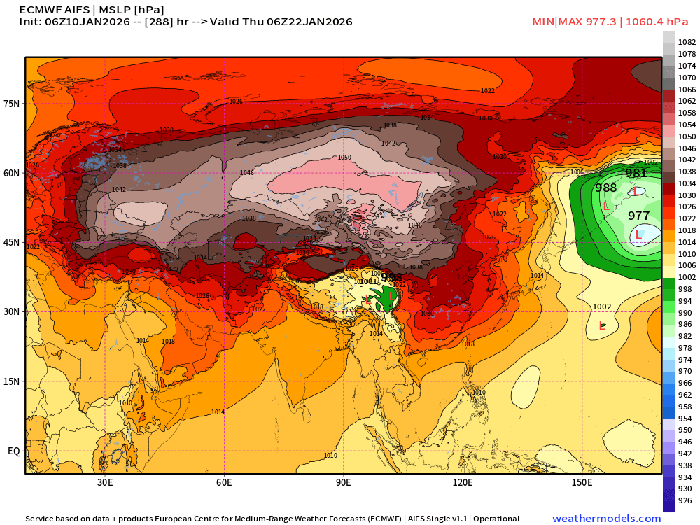
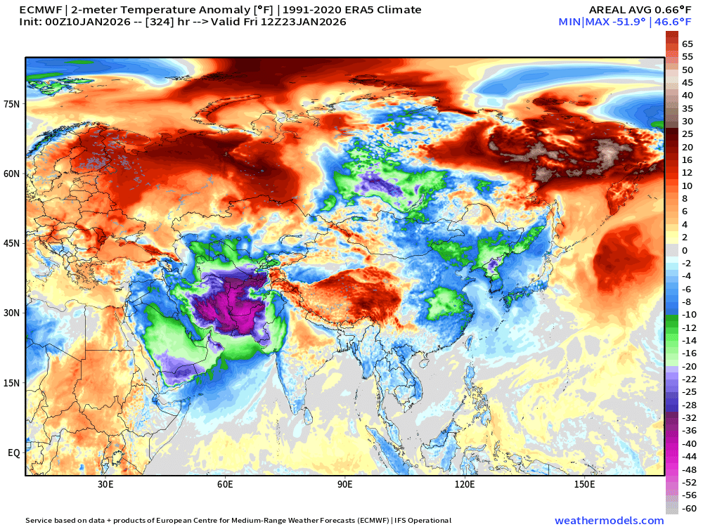
Extreme weather with geopolitical impacts
Need to keep eye on the extreme intensity of the Siberian high pressure system focusing a historic cold "polar vortex" extension into Afghanistan, Iran, and Pakistan in the 8-10 day time frame.
Pattern favors brutal cold & snow