Starting soon all months will be the warmest on record once El Niño kicks into high gear. Biggest impacts on global temp will be later this year into next year. It will set a new precedent… for a couple of years… until it’s broken again.
Wait. For. It. NASA animation shows Global temperatures warm slowly at first, then rapidly. Warming is accelerating! Here’s the truth. It’s real. It’s us. And we have to come to terms with it, and deal with reality, rather than deceiving ourselves, and hoping it goes away. It won’t… without intervention. #climate #globalwarming #science #climatechange
Peak El Niño median forecast is now forecast ONI at +3.3°C (RONI +2.7°C) up .2°C from last month so far.
If it verifies, it will be by far the strongest El Niño on record.
Thanks @hausfath for the great visual.
Today is the 13th anniversary of the 2013 El Reno tornado and Oklahoma county flash flooding, a devastating event that produced the widest tornado on record and tragically claimed the lives of 22 people.
New: Climate change literacy has not budged in years. Largely the result of a huge coordinated disinformation campaign. The science is crystal clear: ALL of the warming is due to humans.
“In the new survey, 90% of Democrats with a postgraduate degree say the Earth is warming mostly because of human activity, compared with 63% of Democrats with a high school diploma or less education.
Around one-in-five Republicans across education levels say climate change is mostly the result of human activity.
Republicans with more education are more likely to say the Earth is warming because of natural patterns: 48% of those with a postgraduate degree say this, compared with 29% of those with a high school diploma or less education.”
Link in thread…
Morons on the @BBCNews moaning about warnings about record-breaking heat waves. They’re really going to have something to moan about when they realise hundreds of millions possibly even more may die in the coming decades because of climate change.
The latest CFSv2 model results for El Nino (ONI) anomalies later this year are kinda nuts, with a peak at nearly 3.9C in November.
NOAA needs to once again raise the y-axis range; here is what it should look like without all the runs above 4C cut off:
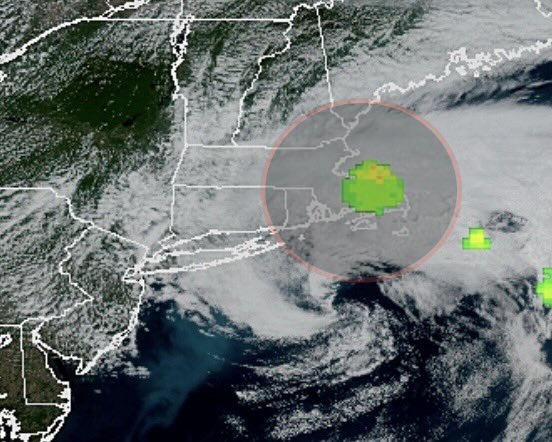
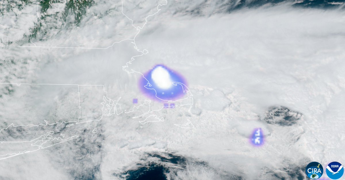
NEW ENGLAND METEOR UPDATE: the space rock had a diameter of about 3 ft before it broke up. According to NASA, it was traveling at 75,000mph & broke up approximately 40 miles above Earth. The energy released equivalent to 300 tons of TNT. The boom/shaking was heard in RI, MA & CT
Reports of an explosion hears around Boston I believe are going to be a rather significant bolide/meteor entering the atmosphere. Very large "flash" detected by GOES-19 GLM that does not correlate with active thunderstorms. #MAwx
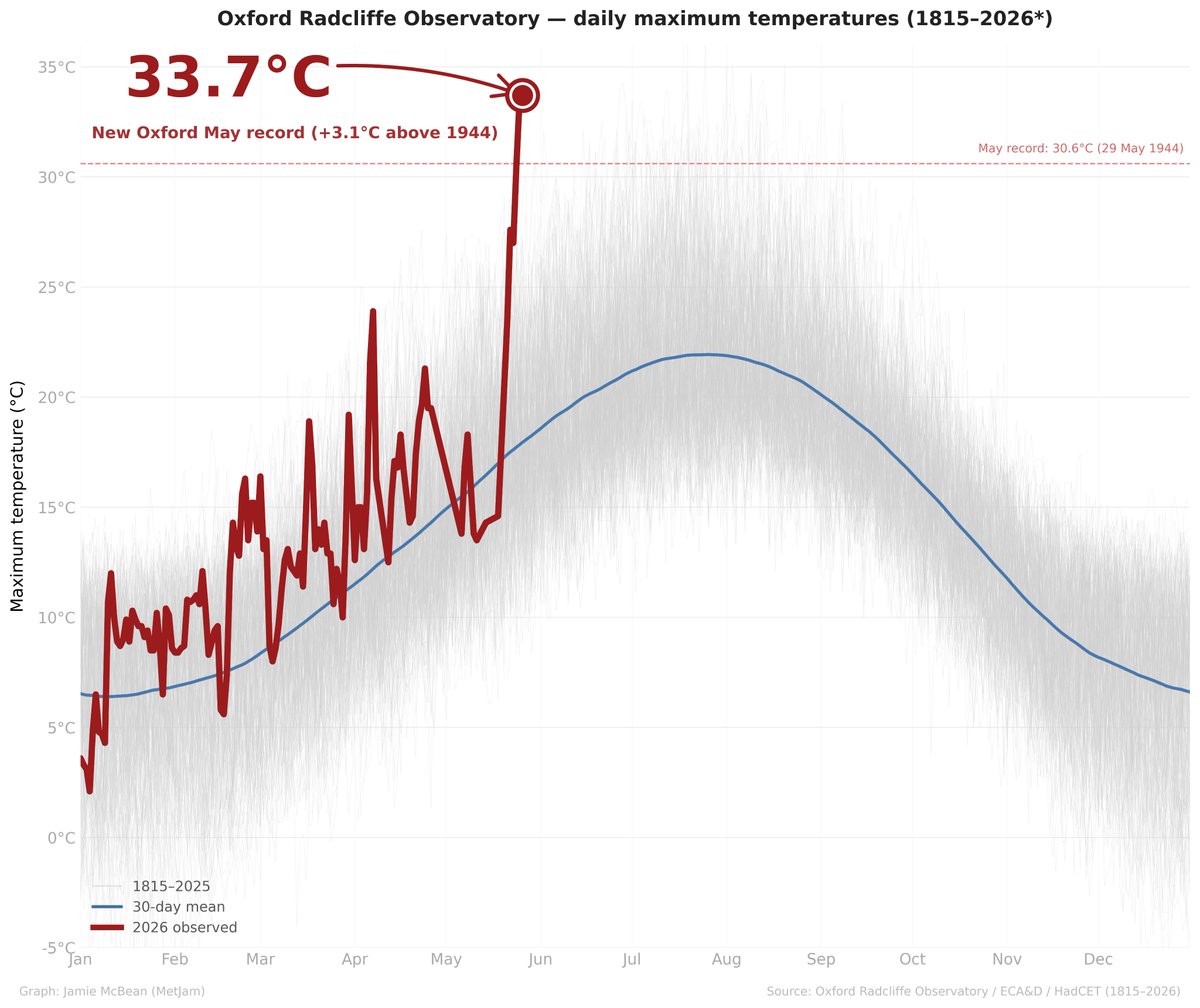
Oxford, the longest running continuous weather station in UK history, with temperature observations stretching back to 1815, has preliminarily broken its maximum temperature record for May yesterday by OVER 3ºC with a temperature of 33.7ºC. Unprecedented in its 211-year history.
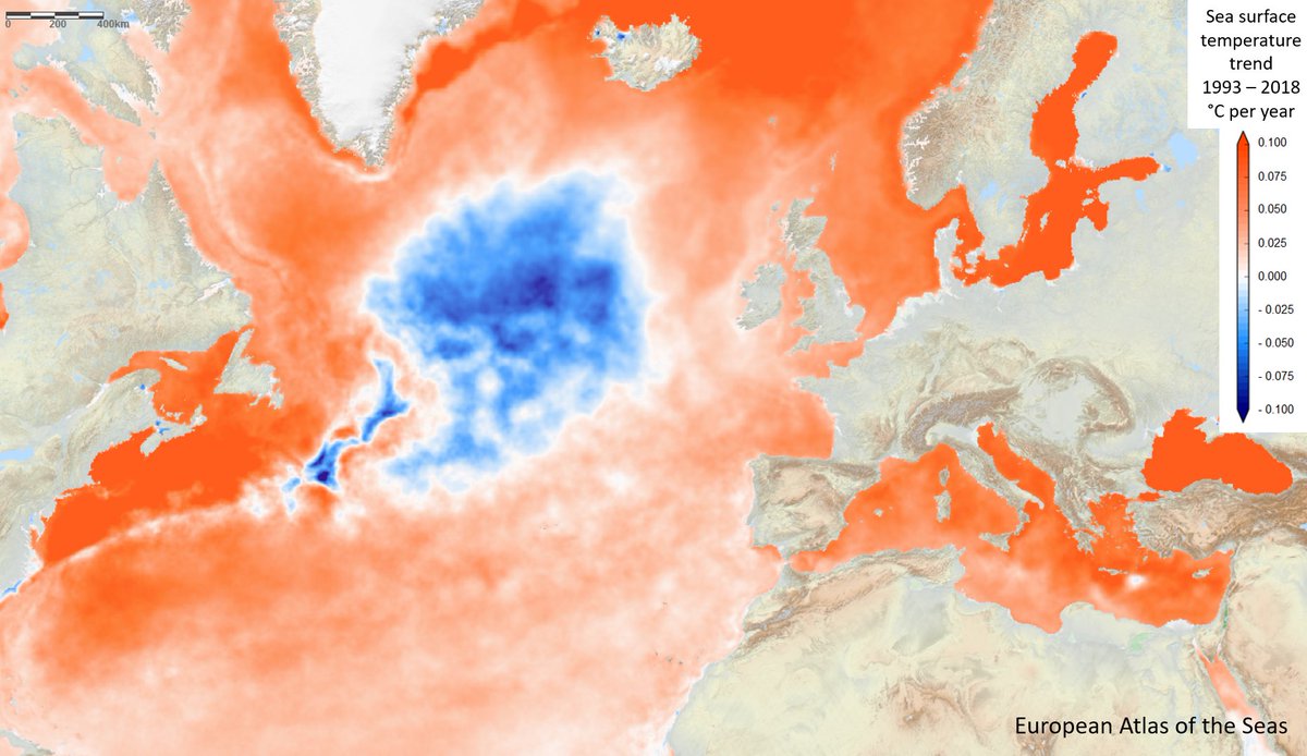
See that cold blob near Greenland? It sticks out like a sore thumb because virtually all of the rest of the oceans are warming. It's a canary in a coalmine signaling something is wrong with our climate system. The cause has been debated and a now a new study from Stefan et al. sheds light, saying this "warming hole" is likely due to less transport of heat into the region due to a weaker AMOC circulation due global warming. Not a big surprise, but it provides clarity.
😯 The ENSO modeling dashboard @hausfath created is showing a 50% chance of a very strong El Niño before the end of the year.
https://t.co/vSUFAwHRvm
These updates are helpful, as the monthly NOAA / IRI reports tend to lag behind the model updates.
This year’s El Niño is developing faster than in 1997 and 1982, based on late-April sea surface temperatures.
The central equatorial Pacific is near 0.8˚C warmer than average, similar to 2015.
But unlike past years, subsurface Pacific waters are now locally 7-8˚C above-average.
@CC_StormWatch I watched radar this afternoon and evening. Whatever popped up on radar struggled mightily to develop further. Capping (hopefully) saved the day.
@CC_StormWatch Not complaining from an impacts perspective (although I qualify my statement by saying...the night isn't over, something could still happen)...but I have to say, I can't remember the last time a PDS Tornado Watch did not verify. Not a single observed tornado as of this tweet.
From 2:30 pm to 9:09 pm on April 27, 2011, there wasn't a single moment where there wasn't an EF-4 or EF-5 tornado on the ground. At a few times there were as many as four ongoing concurrently. That is one of the craziest statistic of 15 years ago.
Heavy rain hit Qinzhou in China today, lasting around 12 hours and triggering severe flooding across the city.
Rainfall reached up to 362.2 mm in some areas, the heaviest in nearly a decade. A red rainstorm warning was issued as roads were inundated, vehicles submerged, and buildings including underground garages flooded.
Authorities urged residents to stay indoors, with some schools suspended.