Introducing RustGIS v0.1.0, the first release!
RustGIS is a fast, free and open-source GIS in pure Rust for mapping, analyzing and sharing geospatial data. It runs natively on Windows, macOS and Linux, and in your web browser. Your data stays on your machine unless you send it to an AI model you choose, and every action is a command you can script.
This first release brings a full desktop GIS with a familiar ribbon, over 1,000 geoprocessing tools, and an AI Assistant that works the map for you.
What it does
- Your data, any map: GeoJSON, CSV, Shapefile, GeoParquet, Flatgeobuf, PMTiles, GeoTIFF and COG, web tiles, vector tiles and MapLibre styles, on a 3D globe or in any projection.
- Cartography and layouts: thematic symbology, collision-free labels, page layouts, map series, PDF export, reports and presentations.
- Analysis: overlay and proximity tools, guided workflows, ModelBuilder, and 1,000+ GeoLibre and Whitebox tools for terrain, hydrology and LiDAR, even in the browser.
- Editing: snapping, templates, domains and attribute rules, with undo for every change.
- AI Assistant: ask questions or give instructions in plain language, using the model you choose (Anthropic, OpenAI, Gemini, Ollama and more).
- Scriptable and extensible: run any command from the command line, and add tools with sandboxed WebAssembly plugins.
- Ready to install: Windows installers, a signed macOS app, Linux .deb, .rpm and AppImage, and 15 interface languages.
Try it out
- Launch the web app: https://t.co/BLtOaf6BoO
- Download: https://t.co/BoF4bkGM5a
- Documentation: https://t.co/PhsUZVbpeq
- GitHub: https://t.co/K7asDzveEr
- Release notes: https://t.co/13A0PIwXMd
#GIS #Rust #OpenSource #Geospatial #RemoteSensing #AI
👁️ How I Track Instagram Posts for Event Monitoring
Most people know how to search Instagram by hashtag.
The problem is Instagram removed the old "recent posts" hashtag feed.
Now hashtags mostly surface popular posts, which doesn't help much when you need to see what was posted minutes ago.
That matters when you're looking into something time-sensitive:
- Protest
- Disaster
- Demonstration
or anything unfolding in a specific place.
When I need to monitor a location instead of a hashtag, I use a free tool from Bellingcat called Instagram Location Search.
The process is simple:
1. Get the coordinates of a location from Google Maps.
2. Enter those coordinates into the tool, along with your Instagram session cookies.
3. Use a separate OSINT account for this, not your personal one.
The tool then creates an interactive map of the area.
Click any point on the map, and it shows recent public Instagram posts made from that spot.
🔗 Tool: https://t.co/n5mGKsNiGZ
P.S. ♻️ Repost if you found this useful.
LO QUE ESTOS TIPOS ACABAN DE PUBLICAR EN GITHUB NO TIENE NINGÚN SENTIDO
un Palantir open source. se llama Osiris.
rastreo en tiempo real:
→ vuelos comerciales, privados y militares
→ satélites y la Iss
→ cámaras públicas de vigilancia
→ terremotos, incendios y fenómenos extremos
→ instalaciones nucleares y zonas de conflicto
herramientas de reconocimiento integradas, sin instalar nada:
→ escaneo de puertos
→ Dns y Whois
→ certificados Ssl
→ reputación de Ip
todo desde un globo 3d interactivo, directamente en tu navegador y totalmente gratis.
más de 1.500 estrellas en solo diez días.
el software de inteligencia acaba de dejar de ser exclusivo.
os dejo el repo abajo.
You can now project points from your Azimut folders onto external maps and use Azimut's GEOINT tools directly on them.
Grid Search, reference media overlay, Sun & Moon calculations, FIRMS layers...
You can even sync multiple map tabs during a geolocation!
OSINT TIP #168 🌞
Shadowmap help visualizing sunlight and shadows anywhere on the Planet.
Sun and the Shadows are used for geolocating objects for Image-Based OSINT Investigations!
https://t.co/w0b9FiUCJX
@shadowmap_org 👏
#OSINT#GEOINT#infosec
https://t.co/qfOqVUZ51a
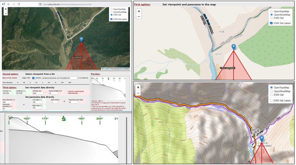
A free OSINT tool for mountain and ridgeline GEOINT. It generates a mountain horizon view from a selected viewpoint.
For additional checks, use it alongside PeakVisor and PeakFinder.
#OSINT#GEOINT#Geolocation
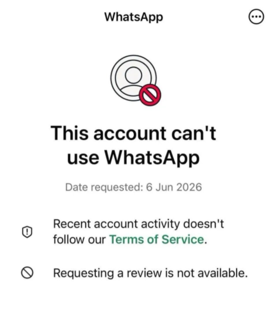
WhatsApp isn't just an app in many countries, it is the comms infrastructure people's lives run on. Unappealablr, device-level bans are exposing how fragile that dependency is. Expect a real, slow drift away from Meta and #OSINT have to catch up with new generational behaviours!!
Every link you share on Instagram/Facebook/Tiktok has hidden tracking parameter (igsh, fbclid, mibextid) tied to YOUR account. When clicked, Meta knows you sent it and receiver can link your profile across platforms. Defense: delete everything in the link after "?" Before sharing
I was curious to see whether Raven (@GeospyAI ) could geolocate a photo.
The result? Incredibly accurate.
AI is changing how online evidence is analyzed. Raven isn’t publicly available but I was given access to test it and its capabilities are both impressive and eye-opening!
Tracing an aircraft with one tail number
Just made a quick video on how to trace an aircraft using only its tail number to pull owner details, airworthiness records, flight history, and the company behind the registration. One number. Full chain. For educational purposes only.
Tonight I typed just one sentence into Google Earth and put refugees near the Mexican border. Then I planted a nuclear plant in Iran. What on earth is Google doing? Check my latest post here: https://t.co/N0h6CVECqS
- Operation Absolute Resolve: The Night Maduro was Taken – A Full OSINT Reconstruction -
The full investigation is finally out. I've designed it to be as visual and easy to navigate as possible, with 4 parts that can be read independently.
I wanted this dossier to be a "one-stop-shop" for the facts:
- Visuals: 2 full videos (2x ~5 min) & GIFs covering strike locations and helicopter movements
- Interactive: a custom map with equipment filters
- Tactical breakdown: From the stealth approach to the final extraction.
RTs are greatly appreciated! I know that nowadays, everyone is looking for quick and easy reads. This isn't one of them, and that was never the goal—this dossier is written for those with a deep, restless curiosity ;)
And, Venezuelans, please take care of yourselves
Full dossier here: 🔗 https://t.co/0zw8fLAhb7
#OSINT #Venezuela #Maduro #OperationAbsoluteResolve
@OSINT_Community@AaronCTI I really like how you used google custom search as a social listening tool, you used the indexation of google in an automated manner, social listening tools subscriptions are getting more and more expensive and SM giants are monetizing all that information.
@BenDoBrown@bellingcat Great example of the risk confirmation bias, just a thought ( can the colour code from the images of sentinel hub be useful in differentiating between a smoke and a cloud??