Incredible--look at the gorgeous eruption produced by an M7.9 flare earlier, sandwitched between the M9.5 and X1. It looks like the CME is headed mostly north of Earth.
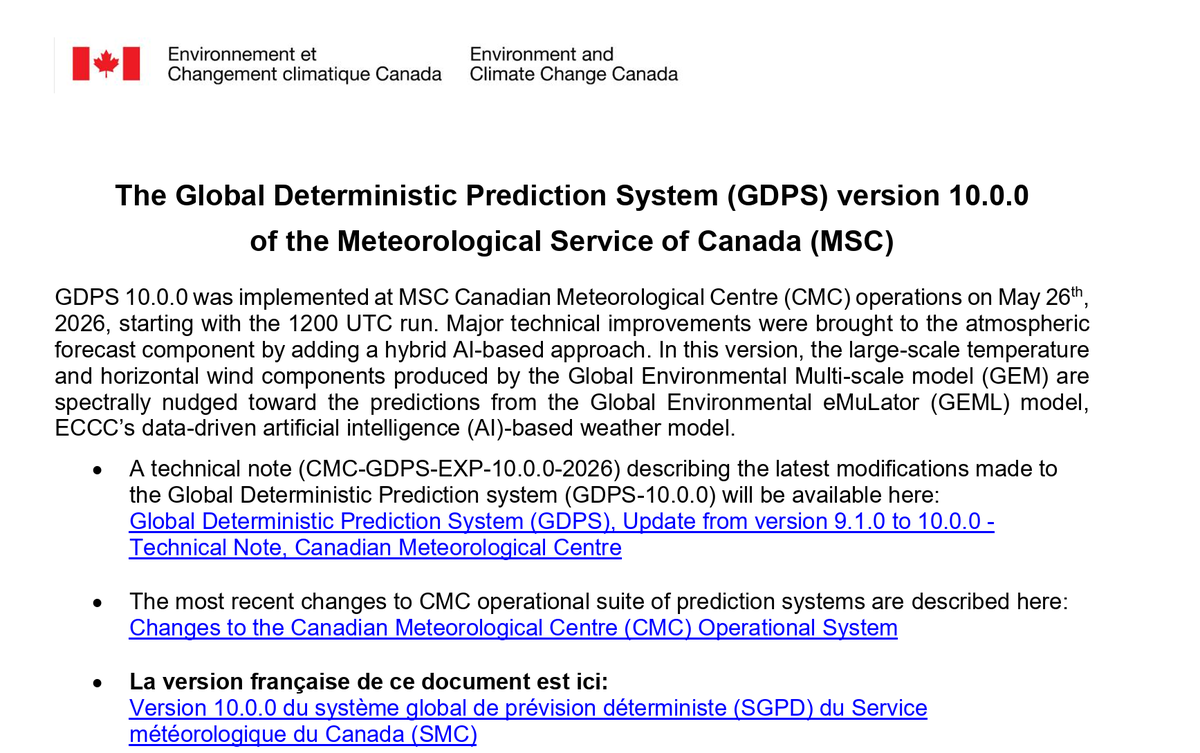
Environment Canada 🇨🇦 upgraded their global weather model today.
Major change: hybrid machine learning (nudging) + full-physics NWP
World's first such global forecasting combined system
--> huge skill gains.
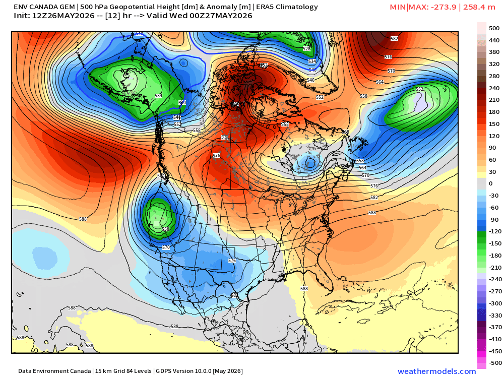
An OMEGA BLOCK pattern will bring high-impact weather to parts of Canada this week.
The greatest effects will be felt in the Prairies:
📈 Record-breaking heat
⛈️ Stormy conditions
🔥 Increasing fire danger
For more details, check it out 👇
Thanks so much! 🌪️ Stack is React + Node.js on the backend.
Real talk though — building the app was the easy part. Getting it in front of the right people? That's the actual challenge. The weather/storm chasing community is exactly who I built this for, so every mention genuinely helps. 🙏
Hey guys — I need your help 🙏
I just launched my new app and I’m trying to get it in front of the right people. If you could give it a quick look, share it, or tag someone who might find it useful, it would mean a lot!
Building something for the weather/storm chasing community 🌪️⚡
More details here 👉 https://t.co/fU1q9AtcX8
Thanks for the support! 💙 #Weather #StormChasing #AI #Startup #wxtwitter
🌬️ High winds are impacting several regions today! ⚠️
• Saskatchewan: Elevated risk — High Winds, gusts up to 97 km/h
• Alberta South: Moderate risk — Strong Winds, gusts up to 81 km/h
• Manitoba: Moderate risk — Strong Winds, gusts up to 85 km/h
• Newfoundland and Labrador: Moderate risk — Strong Winds, gusts up to 73 km/h
Stay aware of conditions!
Valid today.
📡 Source: SkyDraft Weather Map
#ABStorm #HighWinds #CanadaWeather #Saskatchewan #SkyDraft
This is good knowledge.
I know I replied to his thread saying this year I stopped caring, but thats on a personal level and for some other reasons. I would still never ever give my stuff away for free, or to one of these slimy aggregate channels for pennies.
Understand what it is you're signing up for.
🚀 Mega Update for Weather Models
Today, we’re rolling out improvements across every tier, from Free to Pro.
Free:
- New Models:
- HRRRCast
- NSSL HTPO & RN
- HIRESW ARW & FV3
- HREF
- NAVGEM
- REFS (RRFS Ensemble)
- See data values under the map labels
- Personalize the model data with your own custom colortables
Plus:
- Route Planning synced with model data
- Up to 12 hours of model runs available
Pro:
- Flash a range of values to show elevated temperature, wind or reflectivity
- Glided Playback introduces buttery smooth frames
- Model Cross Section Tool
- Up to 24 hours of model runs available
Available now on:
iOS: https://t.co/rrH1bIiWUP
Android: https://t.co/lb3PumjYYE
Browser: https://t.co/16ZMjL3x1l
And to Plus/Pro subscribers using our Windows/Mac/Linux App
🌪️ Big news! I’m now officially recognized as a Super Contributor with the Northern Tornadoes Project!
Years of field experience + documenting last year’s Lefebvre tornado are paying off — proud to see the work recognized.
Thanks to everyone who supports and follows along, it means a lot! 🙌
#StormChasing #Weather #Tornado #Quebec @westernuNTP #SevereWeather