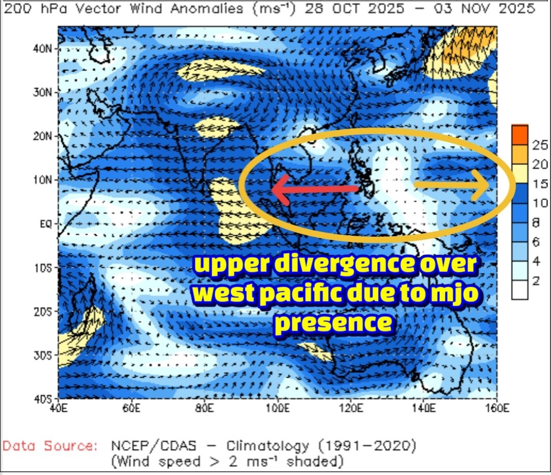
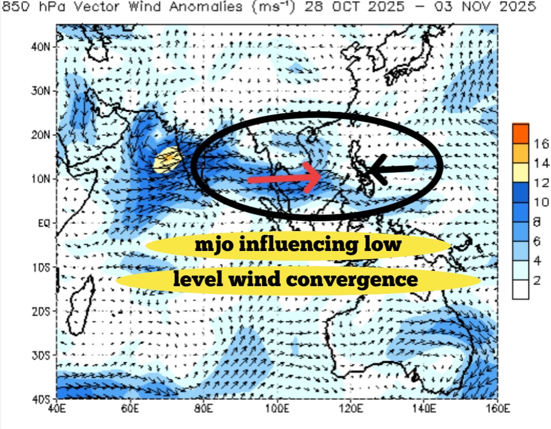
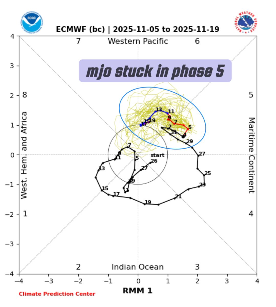
🌀 Understanding the MJO: Why it Appears "Stuck"!
The Madden-Julian Oscillation (MJO) is a naturally occurring, eastward-propagating weather system that cycles through eight distinct phases over a typical period of 30 to 60 days. It does not permanently "get stuck" in any single phase; any apparent lingering, particularly in phases 5-8, is a temporary part of its naturally irregular cycle, influenced by several complex atmospheric and oceanic factors.
⏳ Key Reasons for MJO Slowdown or Lingering: The appearance of the MJO "stuck" in phases 5, 6, 7, or 8 (the Western Pacific to Western Hemisphere) is generally due to the following reasons:
Interaction with the Maritime Continent (Phases 4 & 5):
Phases 4 and 5 occur over the Maritime Continent (Indonesia and the West Pacific). The numerous islands and mountains in this region disrupt the MJO's large-scale convection, slowing its eastward progression and making it notoriously difficult for weather models to predict accurately. Tracking its progress often relies on methods like Outgoing Longwave Radiation (OLR) measurements.
Interference from Major Climate Drivers:
The MJO's signal can be temporarily masked or slowed down by interactions with other large-scale climate patterns. A developing La Niña phase, for example, can suppress the MJO's propagation, effectively "killing the spirit" of its movement. This interference is often visible when Equatorial Rossby Waves (ERW) emerge to the west of the MJO location.
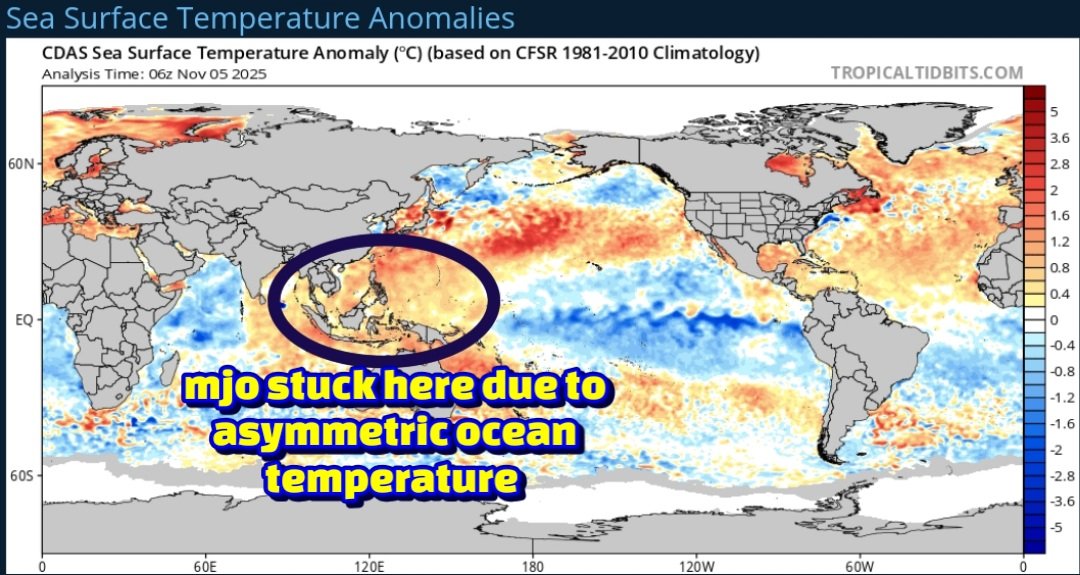
Asymmetric Ocean Warming and LaNiña:
Changes in regional sea surface temperatures, exacerbated by asymmetric ocean warming, have altered the MJO's speed. Slower propagation, particularly over the Western Pacific, can be linked to the developing or "immature" phase of a La Niña event.
Natural Variability:
The MJO's propagation is rarely smooth. Its cycle length naturally varies, sometimes extending up to 90 days. It can also become dormant for periods, contributing to the perception of it being stalled.
Model Limitations:
Current global climate models often struggle to simulate the MJO with perfect accuracy, especially over the complex geography of the Maritime Continent. This can lead to forecast runs that incorrectly show the MJO lingering in a specific phase longer than it does in reality.
🌧️ Northeast Monsoon 2025 Forecast Implications:
The MJO's current behavior holds significant implications for the Northeast Monsoon (NEM) 2025, which affects regions like Chennai.
Scenario 1: MJO Lingers (Negative Impact): If the MJO remains strong in the West Pacific (Phases 6-8) or continues to linger there until the end of November, it is likely to disrupt the monsoon flow over Southern India, potentially leading to a deficit in the Northeast Monsoon.
Scenario 2: MJO Weakens (Positive Impact): If the MJO weakens in the West Pacific or progresses quickly through its phases, it increases the likelihood of a normal NEM performance.
Note: The exact forecast track for the MJO is crucial and typically requires waiting for updates around the 10th of November for a clearer picture.
27 OCT 2026 Evening Bulletin - Very Severe Cyclone Arnab nearing North Andhrapradesh Coast with full power. Stay indoors until state government further instructions!
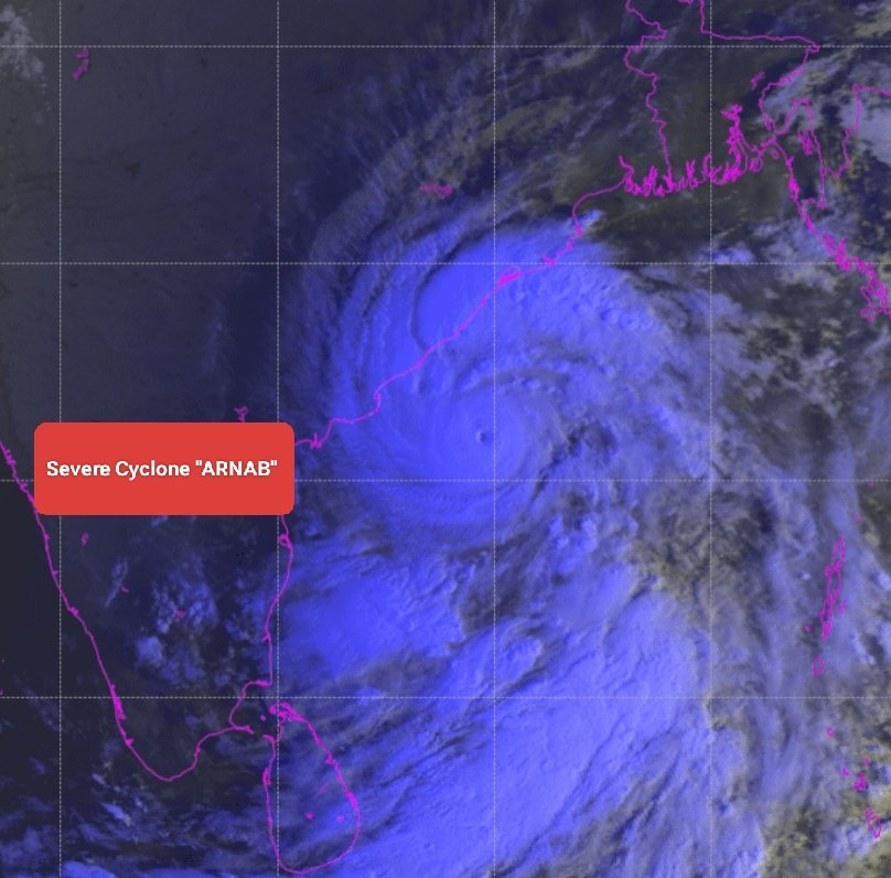
Very Severe #CycloneArnab is now located at 100-120 km east southeast of Kakinada, 90-100 km east of Yanam.
1/5
🛑Wind Pattern Change Alert
Entire North Andhrapradesh coast should remain vigil abd cautious during the next 24 hours. Wind at surface to lower levels of atmosphere will change to easterly or southeasterly over southern quadrant of the system after its landfall tomorrow.
4/5
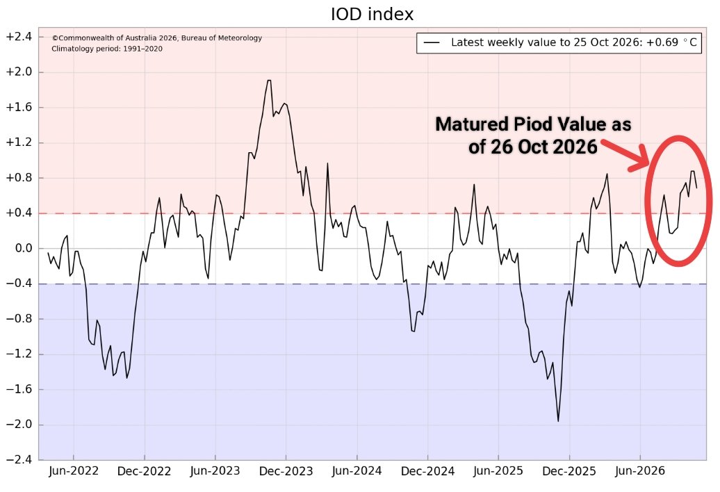
27 Oct 2026: MJO Surges into Phase 3 Alongside Maturing +IOD: Set to Supercharge Bay Cyclogenesis and Northeast Monsoon Downpours Across Tamil Nadu, as I was saying in a video 15 days back!
https://t.co/O1lcx8qQ8u
#chennairains#northeastmonsoon#cyclonarnab#CycloneAlert
27 OCTOBER 2026: VERY SEVERE CYCLONE ARNAB OVER WEST-CENTRAL BAY: Compact eye feature evident on infrared satellite imagery with deep convective banding wrapping around the core. System will weaken before landfall due to approaching dry air from west!
https://t.co/wnKWy1oeY2
🌀High Alert Zone from Bhubaneswar to Bhimavaram. This is where the severe impact to happen, where intense rainfall, high wind and tidal waves possible!🛑
#CycloneArnab#CycloneAlert#AndhraPradeshNews
@Deltarains Chennai District Rainfall during nino and piod year, similar Oct performance.
In 2002
October 287 mm
November 343 mm
December 41 mm
NEM Total 673 mm
Below Normal
In 2006
October 646 mm
November 258 mm
December 20 mm
NEM Total 925 mm
Slightly above normal.
#ArnabCyclone you are just crazy. System stagnant near to North Coastal Andhrapradesh for nearly 12-18 hours. It looks like as if, it is stuck near that "Hope Island"?
If this slows down, then take extra care North Coastal #Andhrapradesh . It can dump extreme downpour.
@Sathyargb It will destroy everything, massive loss. Cyclones with this intensity is just useless. We need water, not destroyer. Remember Vardha, we were without power for a week..
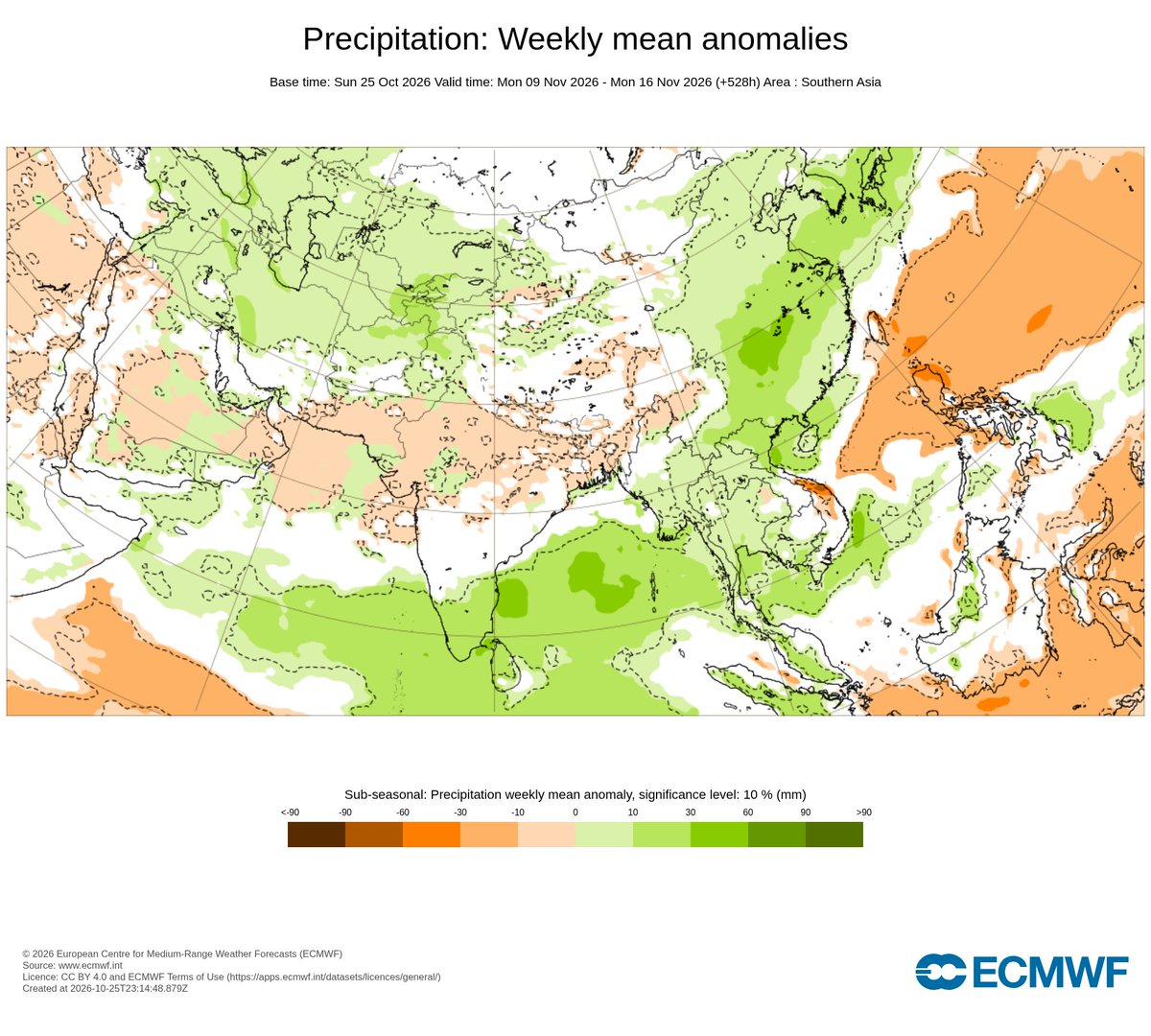
26 October 2026: Active Northeast Monsoon Wave Ahead: ECMWF EPS projects persistent above-normal rainfall across South Peninsular India and the Bay of Bengal through the first half of November.
https://t.co/qsC9ByHwGe
How many media, how many bloggers created a mockery in the name of this Cyclone?
So many were saying that this systems name is "Murasu", I have corrected them with "Arnab", but keeps coming.
If you do not have authentic information, dont post #ArnabCyclone#CycloneUpdate
Subject: Deep Depression intensified into Cyclonic Storm “Arnab” [Pronunciation : Ornab] over Eastcentral and adjoining Westcentral Bay of Bengal [Cyclone Warning for Andhra Pradesh and adjoining South Odisha coasts—Red Message]
The Deep Depression over Eastcentral and adjoining Southeast Bay of Bengal moved nearly westwards with a speed of 15 kmph during last 6 hours, intensified into cyclonic storm ““Arnab” [Pronunciation :Ornab]” and lay centered at 0530 hrs IST of today, the 26th October, 2026 over Eastcentral and adjoining Westcentral Bay of Bengal near latitude 15.4°N and longitude 88.9°E, about 590 km northwest of Sri Vijaya Puram (#Andaman Islands), 610 km southeast of Gopalpur (Odisha), 650 km east-southeast of Vishakhapatnam (Andhra Pradesh), 730 km east-southeast of Kakinada (Andhra Pradesh), 830 km east of Machilipatnam (Andhra Pradesh) and 910 km east of Bapatla (Andhra Pradesh).
It is very likely to move west-northwestwards and intensify further into a severe cyclonic storm over westcentral Bay of Bengal by midnight of today, the 26th October and into a very severe cyclonic storm over the same region on 27th October.
Thereafter, it is very likely to move northwestwards and cross Andhra Pradesh & Yanam coasts between Bapatla and Visakhapatnam as a very severe cyclonic storm with the maximum sustained wind speed of 115-125 kmph gusting to 140 kmph by forenoon of 28th October, 2026.
26 October 2026: Flash News - #CycloneArnab formed over East Central Bay of Bengal. Intensify further into a Severe Cyclone in next 24 hours and move westward!
https://t.co/DuUa2ZDKyc