Providing up to date weather, news, safety information and more on a variety of topics for Phelps and beyond to help keep you safe and informed. ~ Steve
A few potential rounds of strong to severe storms are expected this morning through tonight. Primary hazard this morning will be damaging wind gusts. For this afternoon and tonight, the primary hazards will be large hail and damaging wind gusts. A secondary hazard of a tornado.
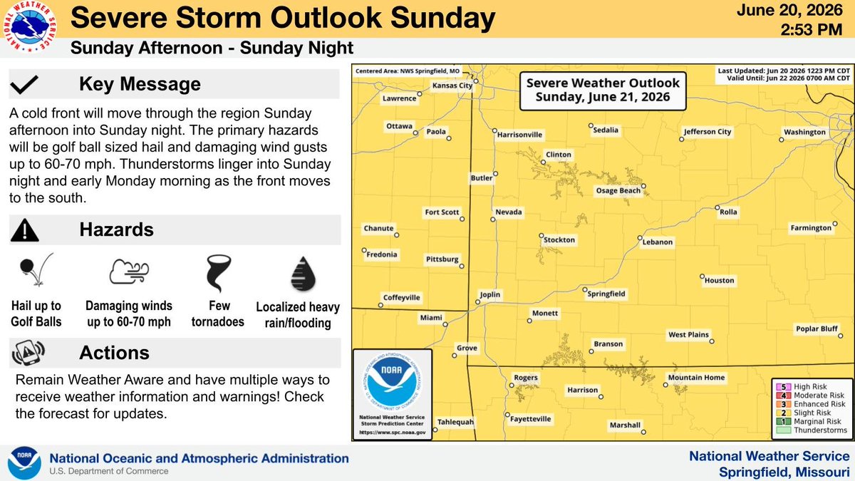
A cold front will move through the region Sunday afternoon into Sunday night. The primary hazards will be golf ball sized hail and damaging wind gusts up to 60-70 mph. Thunderstorms linger into Sunday night and early Monday morning as the front moves to the south.
A cold front will move southeast through the region Sunday afternoon and evening. Storms are expected to develop along the front with hail to the size of golf balls, damaging winds, and heavy rainfall the main risk. #sgf#mowx#kswx#ozarkswx#midmowx
A cold front will move southeast through the region Sunday afternoon and evening. Storms are expected to develop along the front with hail to the size of golf balls, damaging winds, and heavy rainfall the main risk. #sgf#mowx#kswx#ozarkswx#midmowx
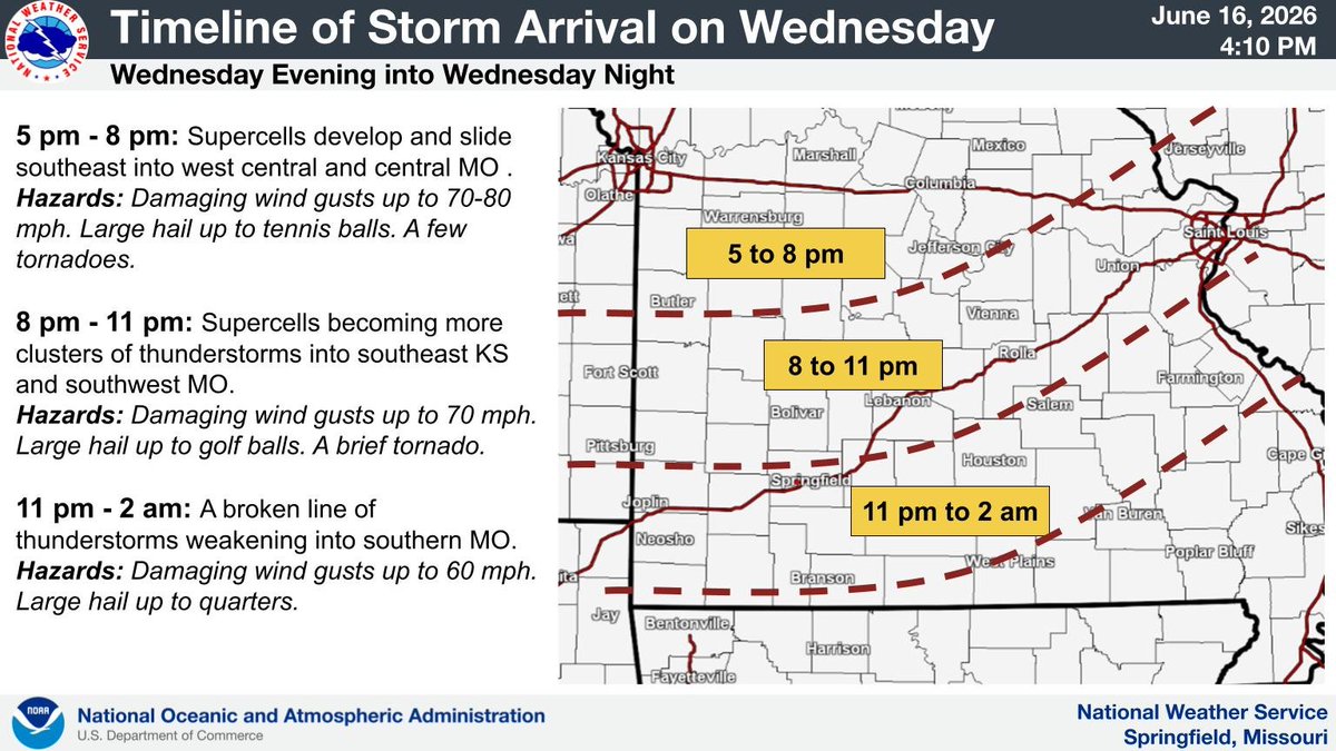
Here is an estimated timeline for thunderstorms developing and moving into and through the area late this afternoon and evening into tonight. Remain weather aware this evening, especially across central Missouri. #sgf#mowx#kswx#ozarkswx#midmowx
Wind gusts will increase this morning and remain gusty through this afternoon between 30-45mph, especially along and north of Interstate 44. These are general winds, outside of any thunderstorms. #sgf#mowx#kswx#ozarkswx
From the National Weather Service in Springfield Missouri.
A timeline and possible hazards associated with each for Wednesday afternoon and night. Please stay weather aware.
Here is an estimated timeline for thunderstorms tomorrow evening. Remain weather aware tomorrow evening, especially across central Missouri. #sgf#mowx#kswx#ozarkswx#midmowx
Remain weather aware for the potential for severe thunderstorms Wednesday evening and night. The highest chances remain across central Missouri. There is also a localized flash flood threat Wednesday night. Remain weather aware! #sgf#mowx#kswx#ozarkswx#midmowx
Commonly accepted misconceptions about tornadoes often lead people to make mistakes when preparing for severe weather. Read up on more myths & check out the videos on how to stay safe no matter where you are at https://t.co/2zI4ahqvrD. #MoWx
🚨 Emergency responders: Undeployed ballistic parachute recovery systems (BPRS) can pose serious hazards after an aircraft accident. Know the risks before working on scene. #AviationSafety#NTSB
Watch: https://t.co/ZkL5iIHHNQ
Read the Safety Alert: https://t.co/RGSJlrZQZS
Did you know the air temperature can actually feel hotter than what the thermometer reads? The Heat Index is a measure of how hot it really feels when relative humidity is factored in.
To find out how hot it feels, you can use the pictured chart or the Heat Index calculator found at: https://t.co/kJW7ghouLu
Important weather information.
NWS Springfield YouTube briefing concerning flooding and severe weather expected with all modes of severe weather possible. Please review your plan now. And keep up to date on the latest weather forecast and conditions
#mowx
Here is our YouTube briefing on the severe weather and flooding potential this weekend. The first chance for thunderstorms occurs overnight, before additional rounds are expected from Saturday afternoon through Sunday morning. https://t.co/wDfriJwh42
In soccer, there might be stoppage time.
In lightning safety, there definitely is.
After the last rumble of thunder, how long should you wait before going back outside?
A. Once the rain stops
B. 90 min + stoppage time
C. 30 min
D. Until referee says it's okay
Answer below before checking the answer in our reply 👇
There is the potential for strong to severe thunderstorms on Thursday afternoon into Thursday evening. The primary hazards are large hail and damaging wind gusts. If shear increases, a tornado threat may materialize. Localized flash flooding may occur where repeated thunderstorms
A Red Flag Warning is issued when critical fire weather conditions are happening or about to happen. It does not necessarily mean there is a fire, but that conditions will be very dry and windy. If a fire is present, it can become extreme! Avoid activities that could spark a wildfire!
Red flag warnings are currently active across portions of the West. Check https://t.co/qk3BcVP5M8.