Exciting News! Site Scout 360 is Heading to Bisnow Multifamily Annual Conference (BMAC) East! 🌆
We're bringing cutting-edge 360° scanning technology to transform how multifamily projects are planned, documented, and executed.
#MultifamilyConference#RealEstateTech#360video
As the gold standard in SLAM-based mobile mapping, Emesent is offering one lucky person the chance to win their own Hovermap ST-X. This is no ordinary LiDAR scanner. It's the world’s first – and only – Golden Hovermap. Find out how to enter the draw here: https://t.co/Hi2BIy6De4
How does Site Scout 360 perform reality capture so quickly?
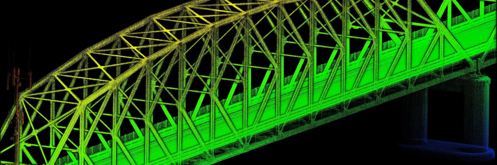
We use mobile LiDAR technology, which means instead of setting up tripod-based scanning equipment in different locations throughout your site, we are able to walk the entire site, continuously collecting scan data #scan
At Site Scout 360, we care about customers and team safety.
Site Scout 360 previous Campus/Urban project: Size: 180,000 square feet . Office Renovation/ADA Site Documentation: Collect as-is condition for structural, ADA, MEP. Focus Areas: Campus-wide data collection.
#ADA
Site Scout 360 reduces the need to return to the project site.
Our previous Waterfront & Structural project:
Size: 1,400 foot by 400 foot waterfront structure
Warehouse: 1,000 foot by 200 foot warehouse on pier
Concrete Piles: 4,300+ individually placed piles
#3DScanning
In what phase of my construction or renovation project is SiteScout360’s reality capture service most useful?
Our reality capture service is most useful during the project planning phase, but it is also beneficial throughout your project life cycle.
#faq#3DScanning#360video
Save money and time on renovation projects and security system projects.
Site Scout 360 removes unknown site conditions by using 360 degree video. This cuts 30% of all costs for projects and we make video and CAD documentation to use with your design team.
#360video#cutcosts
What industries are reality capture and digital twins used for?
Reality capture and digital twin technology is used across many different industries, most notably in the AEC industry and the aerospace, automotive, transportation, energy, manufacturing, and security industries.
How can Site Scout 360 assist A&E firms?
Site Scout 360 provides Asset management tools: We create digital inventories of building components and systems for facility management.
Check out our website for more info: https://t.co/SGxUwfgE8q
#FAQ#3DScanning#RealityCapture
Need to improve your convergence monitoring program? Find out how at MINExpo 2024. Visit us at MINExpo booth #12040 to see how Emesent Hovermap captures high-definition data quickly to help you make better, more informed decisions: https://t.co/SocsYUCxNG
Come and see the award-winning Hovermap in action at our next demo day. Emesent will be visiting Melbourne, Sydney and Canberra between 30th September and 11th October. Register your interest now and tell us what you’d like to see: https://t.co/lyWUifB3JX
Automatically filter out the sky from 360 camera images with the latest Emesent Aura update. By optimizing colorization results for outdoor scans, Aura ensures that the sky color doesn’t impact the colorized point cloud. Learn more about Emesent Aura here: https://t.co/GgoOkcsto9
Don’t miss out on our next webinar: Unlocking Efficiency in 3D Mapping: A Journey with Emesent’s Hovermap, Aura, and SLAM Technology. Register now to secure your spot: https://t.co/lfS7ECZ0Xm
Minimize risks & maximize mine productivity with the Hovermap LHD mounting kit, engineered to enhance safety and operational effectiveness. This mount easily attaches to your Load Haul Dump to enhance visibility in underground environments. Learn more: https://t.co/JAc9vLrFWn
This scan of a sports field in Australia was captured using an Emesent Hovermap ST-X attached to a DJI M350 RTK drone. Download the dataset now and explore it yourself: https://t.co/BTbSISL6iL
Emesent Vehicle RTK allows you to scan over large areas and long, linear assets without the need for GCPs. Register for this webinar which explores a report prepared by independent surveyor Orion Spatial Solutions testing the accuracy of Vehicle RTK: https://t.co/DaQV3x799a
Visualize an entire stope in minutes with Emesent’s latest release – Hovermap LHD. Hovermap LHD is a state-of-the-art solution that delivers near real-time 3D visualization of entire stopes, even in zero-light conditions. Find out more here: https://t.co/vdr1VQy223