Elevated fire weather conditions develop this weekend from a combination of dry and windy conditions with strongest winds on Sunday. Be sure to practice fire safety and avoid activities involving open flames or sparks. #CAwx
With dry conditions and gusty winds expected this weekend, here are some tips on maintaining wind and fire safety this weekend! Please continue to monitor the latest forecast at https://t.co/xxs4pW0VeN. #CAwx
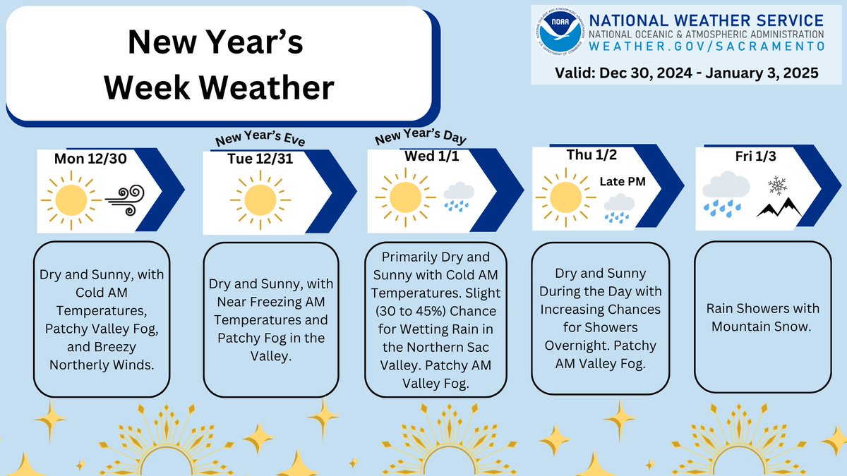
As we approach 2025, here's a look at the forecast for this week. Cold overnight & early morning temperatures are expected through New Year's with chances for rain later in the week. Remember to grab a coat before heading out to celebrate! #CAwx
Forecast: https://t.co/WjKBsJmSfA
After 24 years, Captain Alejandro “Hano” Saise is retiring. Hano was a member of the Peer support/CISD team. Hano’s CISD training helped with getting fellow workers and Paradise through the Camp Fire. He was beloved by those he worked with and for. Enjoy retirement Hano!
We are in the middle of a brief precipitation break currently, but precip chances will return later today, especially in Shasta County. Here's a look at the simulated radar through tomorrow. #CAwx
Cold temperatures are expected overnight across interior NorCal but some high clouds dropping south may temper the drop. Take precautions with tender plants and cover up or move inside. #cawx
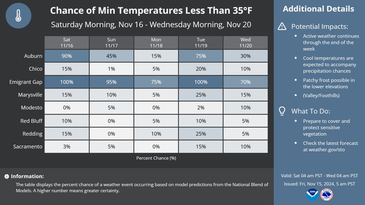
There will be a chance of frost over the weekend in the early morning hours in some areas of the Valley and foothills. Make sure to cover or bring inside cold sensitive vegetation. See below for probabilities of minimum temperatures less than 35F. #CAwx
Please join us in congratulating Fire Apparatus Engineer Tanner Brady on his recent promotion. FAE Brady started his career as a Forestry Aide Defensible Space Inspector in the Tehama-Glenn Unit. Congratulations on graduating the Company Officer Academy on November 15, 2024.
Chilly temperatures expected across interior NorCal. Watch for patchy frost overnight. Take in sensitive plants. At 10 pm it was 52 degrees in Vacaville, 43 in Fairfield, Sac Exec Arpt 46, Rancho Cordova 43, Marysville and Stockton 48, Modesto 47 and Blue Canyon 30. #cawx
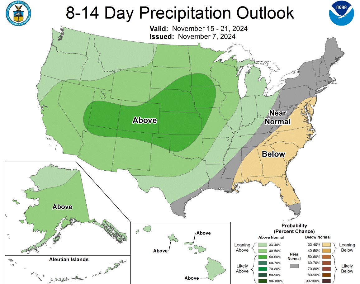
The 8 to 14 Day Precipitation Outlook valid for 11/15 through 11/21 indicates precipitation chances leaning above normal for the interior NorCal region. #cawx
Gusty winds will develop this evening and continue through Wednesday morning. The strongest winds are expected in the Delta from 10 PM tonight through 7 PM Wed. Make sure to secure loose objects, drive carefully and watch for downed tree branches. #CAwx
Here comes the rain again. Watch for slippery spots on the freeway ramps, bridge decks and intersections. Snow is expected to develop over the high mountain passes by this evening. #cawx
Along with mountain snowfall, widespread rainfall is anticipated across the Valley. Generally, around 0.10-1.00" inches is forecast, with highest totals in the Foothills and northern Sacramento Valley. #CAwx
Rain is in the forecast starting late this weekend, which means now is a good time to prepare. Get ready for precip by:
🍂Clearing leaves and debris from storm drains
🏠Clean house gutters
🚗Check wiper blades
☂️Get out your umbrella/rain gear
#CAwx
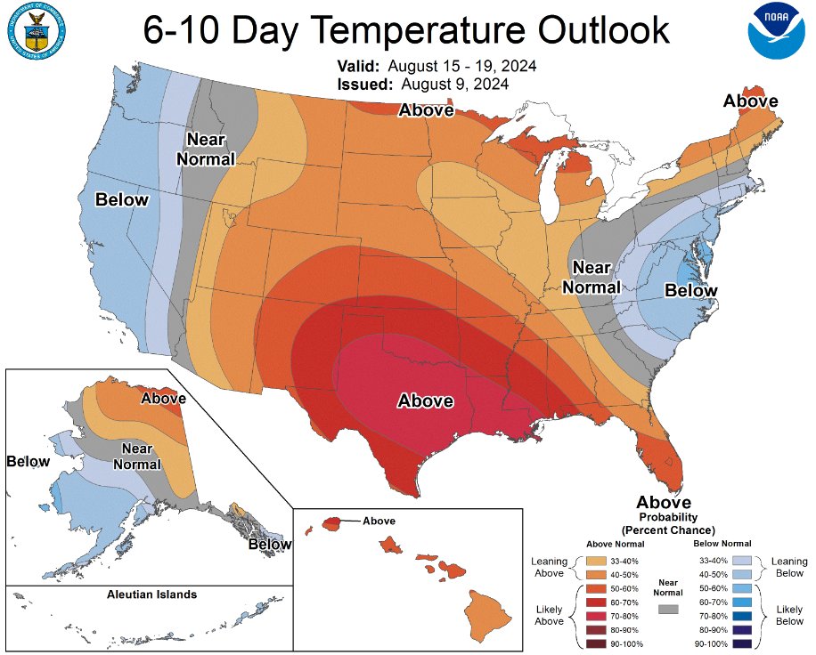
The longer range Temperature Outlook is leaning toward cooler than normal temperatures for the West Coast region and interior NorCal valid for the period of August 15-19. #cawx
It doesn't take long in the summer heat for your car to get VERY HOT! You may think it's not a long time but even after 10 minutes temperatures can be dangerous to any people or pets left inside. Cracking the windows makes less than a 5 °F difference! Look before you lock! #CAwx
Elevated fire weather conditions are expected for this week due to hot temperatures, occasionally breezy winds and low humidity. Stay fire aware. #CAwx
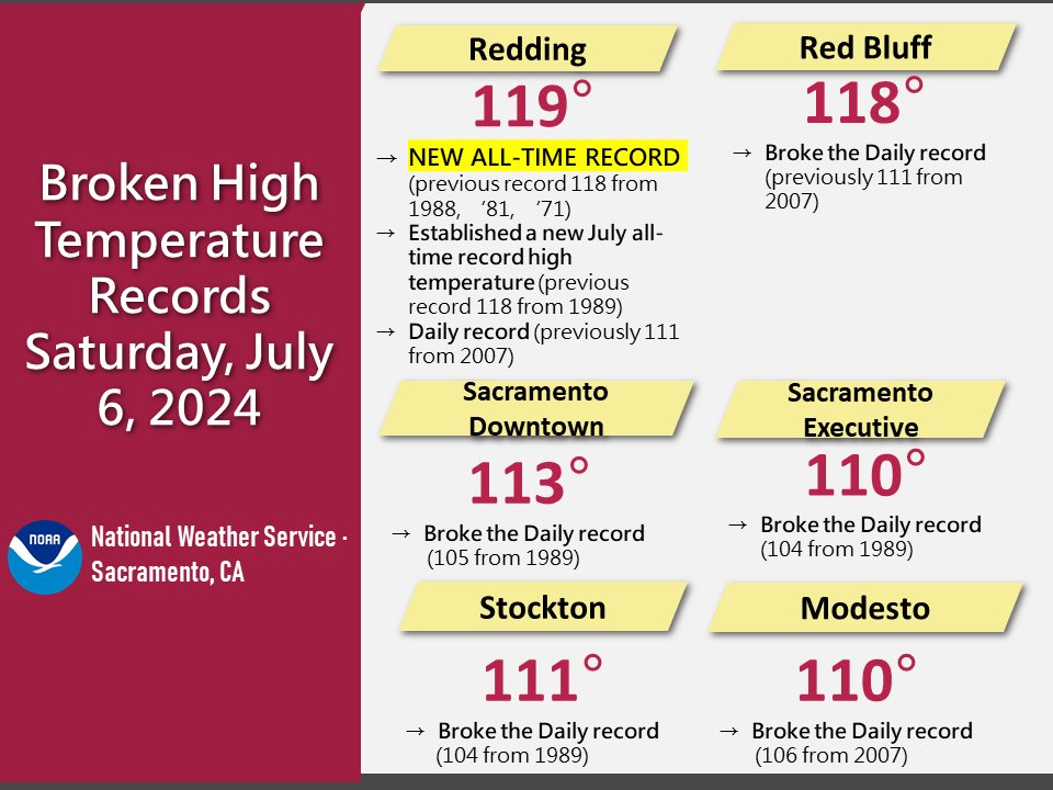
Oh, we didn't just break records. We SMASHED them! Here's a collection of some of the high temperature records we broke this past Saturday, July 6, 2024. #CAwx


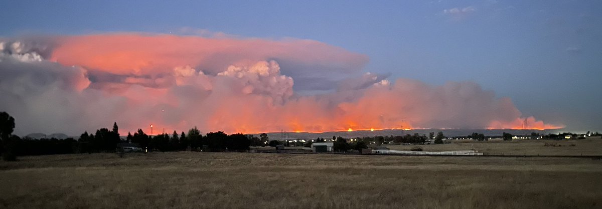
![CALFIRE_ButteCo's tweet photo. #ParkFire [update] The Park Fire has burned 353,194 acres total and is 12% contained. It has burned 52,850 in Butte County and 300,344 in Tehama County.
For more information:
https://t.co/Pu6WfXitx1
@ButteSheriff @CountyofButte @CALFIRETGU @ShastaCountyGov @CALFIRESHU @LassenNF https://t.co/iMBRVnmjYj](https://pbs.twimg.com/media/GTlVr5fbUAAe4b-.jpg)


![CALFIRE_ButteCo's tweet photo. #ParkFire [update] The Park Fire has burned 353,194 acres total and is 12% contained. It has burned 52,850 in Butte County and 300,344 in Tehama County.
For more information:
https://t.co/Pu6WfXitx1
@ButteSheriff @CountyofButte @CALFIRETGU @ShastaCountyGov @CALFIRESHU @LassenNF https://t.co/iMBRVnmjYj](https://pbs.twimg.com/media/GTlVuqZbEAAQZSy.jpg)