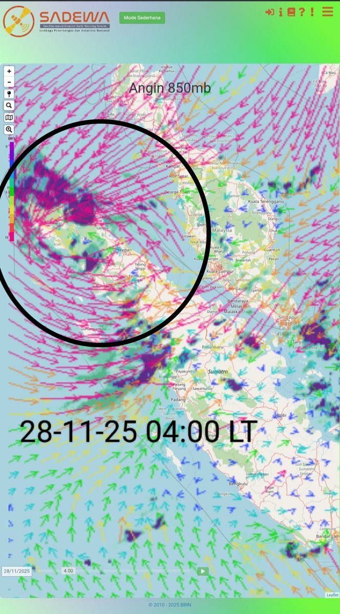
Flash flood again this afternoon in Malalak, West Sumatra, Indonesia.
Death toll rises to 921, with 329 still missing following devastating floods and landslides in Sumatra.
BREAKING: CCTV captures the moment a powerful 7.2-magnitude earthquake strikes Aomori Prefecture, Japan.
Tsunami waves detected following an earthquake, says JMA.
This incident occurred on November 26, 2025, in the highlands of Bener Meriah, Aceh. The video was only recently uploaded to social media because internet and electricity were only recently available.😢
This footage capture the terrifying moment when a flash flood struck the Kayu Pasak area of Salareh Aia, Palembayan, Agam Regency, West Sumatra, Indonesia.
• Deaths: 914
• Missing: 389
🇮🇩 Oh no! A massive flash flood in Malalak, West Sumatra in Indonesia today.
Malalak has already suffered enough.
It's relentless 🥺
Latest casualty update from across Sumatra:
Deaths: 921 people
Missing: 392 people
Injured: 5,000 people
Siklon tropis yang sangat langka terjadi di lintang rendah jadi penyebab bencana hidrometeorologi di Sumatra beberapa hari ini.
Ini mengingatkan kita bahwa climate change itu nyata dan sangat dekat dengan kehidupan kita — kapanpun bisa mengintai. Negara tropis seperti Indonesia sangat rentan terdampak bencana yang ditimbulkan.
Severe flooding across Aceh, Tapanuli, and Sibolga has caused a major blackout that has disrupted essential infrastructure and affected homes, public services, and communication networks across the region.
🌵Ke kebun bawa pacul,
Dua siklon lagi muncul! 🌪️
BMKG memantau 2 Siklon (26 Nov 2025, 07.00 WIB).
• KOTO: Hingga 40 knot, bergerak menjauhi Indonesia
• SENYAR: Hingga 43 knot, bergerak ke barat–barat daya menuju indonesia
⚠️ Dampak SENYAR (24 jam ke depan):
• Hujan ekstrem: Aceh, Sumatera Utara
• Hujan sedang–lebat: Sumatera Barat, Riau
• Angin kencang: Aceh, Sumatera Utara
• Gelombang 2.5–4.0 m: Selat Malaka utara, perairan Aceh, Samudera Hindia barat Aceh hingga Nias
⚠️ Dampak KOTO (24 jam ke depan):
• Hujan sedang–lebat: Kalimantan Barat, Kepulauan Riau
• Gelombang 2.5–4.0 m: Laut Natuna Utara
Tetap waspada dan pantau info resmi BMKG! 💨☔
#BibitSiklonTropis #BMKG #InfoBMKG #SiklonTropisKOTO #SiklonTropisSENYAR
Cyclonic Storm #Senyar continues to be an exceptionally rare event for this region.
Only a handful of tropical cyclones in the historical record have formed in the Strait of Malacca, and Senyar is both the southernmost and the first to attain official wind speeds of at least 35 kt.
Potensi dampak bencana hidrometeorologi akibat siklon Tropis Senyar masih tinggi dan perlu diwaspadai di wilayah Aceh, Sumatra Utara, Kepulauan Riau, Riau, Sumatra Barat, dan sekitarnya hingga 2-3 hari ke depan.
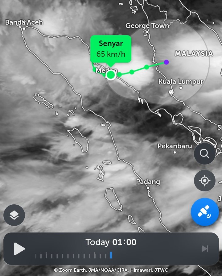
Wow, #Senyar has a rather pronounced mid level spin over #NorthSumatra, #Indonesia. Senyar is about to emerge over the Strait of Malacca & make its way towards #Malaysia, which will be a once in a generation landfall for 🇲🇾's Malay Peninsula west coast.
#IDNwx#MYSwx#tropicswx
#tropicswx#IDNwx |
Here's some stats regarding #Senyar:
- Strongest landfalling TC in #NorthSumatra, #Indonesia on record, beating Vamei '01
- 2nd landfalling TC in the NHem part of 🇮🇩 in its history
- 1st ever NIO named storm to make landfall in 🇮🇩
- 🇮🇩's first landfall overall since Lili '19
- 🇮🇩's first landfall in November since TS 03S '01.
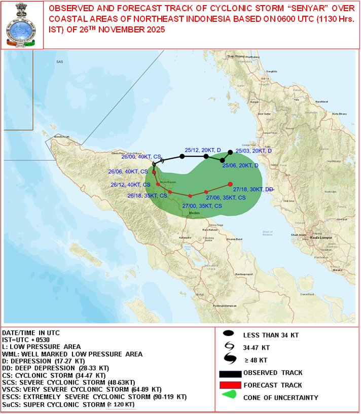
(A) Cyclonic Storm "Senyar" [Pronunciation: 'Sen-yar'] over coastal areas of northeast Indonesia
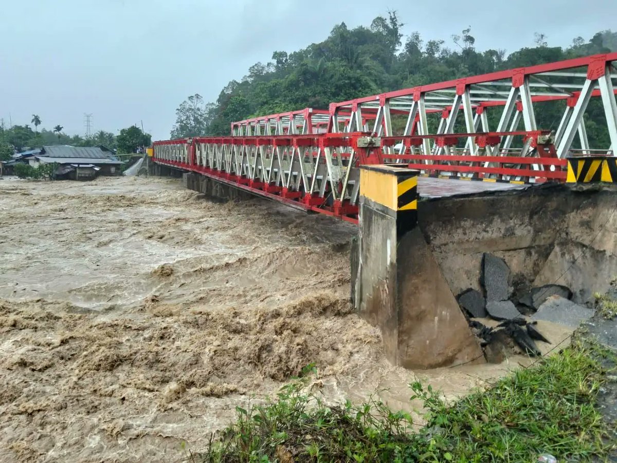
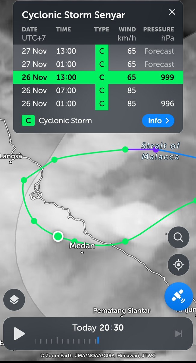
The #cyclonic_storm#Senyar [Pronunciation: 'Sen-yar'] over Strait of Malacca and adjoining Northeast Indonesia moved west-southwestwards with a speed of 13 kmph in past 6 hours and crossed Indonesia coast near 4.9°N between 0730-0830 hours IST with wind speed of 70-80 kmph gusting to 90kmph, and lay centered at 0830 hours IST of today, the 26th November, 2025 over coastal areas of northeast Indonesia near latitude 4.9°N and longitude 97.8°E, about 80 km east of Kuta Makmur (Indonesia), 280 km west of George Town (Malaysia), 580 km southeast of Nancowry (Nicobar Islands) and 730 km southeast of Car Nicobar (Nicobar Islands).
It is very likely to continue to move west-southwestwards and maintain the intensity of cyclonic storm till 27th early morning. Thereafter, it is very likely to recurve eastwards with gradual weakening during subsequent 24 hours.
(B) Well Marked Low pressure area over southwest Bay of Bengal and adjoining areas of Southeast Sri Lanka & Equatorial Indian Ocean
The Well marked low-pressure area over southwest Bay of Bengal and adjoining areas of Southeast Sri Lanka & Equatorial Indian Ocean persisted over the same region at 0830 hours IST of today, the 26th November, 2025.
It is very likely to move nearly north-northwestwards and intensify into a depression during next 24 hours. Thereafter, it is very likely to intensify further and continue to move north-northwestwards across southwest Bay of Bengal towards North Tamil Nadu & Puducherry coasts during subsequent 48 hours.
A destructive flood and landslides have struck Tapanuli and Sibolga, North Sumatra, leaving widespread damage, isolating communities, and causing a total outage of both electricity and internet access.
(https://t.co/QAYj3BDbFC)
Definitely agree! Since now 04B named Senyar, this TC recorded as the second as tropical cyclone in lesser latitude after Vamei in 2001. Notably, it is also proved that, this once of the 100-400 years event now become 20-40 years. Senyar may intensify on 28 November over Aceh.
Pretty sure Invest 95B has been a tropical storm for a while now, albeit a sheared one, and at an extremely rare location — just below 5°N between Malaysia and Sumatra (Indonesia)! Fortunate to have successive scatterometer passes over the system today.
LANDSLIDE WATCH
Landslide - North Sumatra Highlands, W of Padangsidempuan, Sumatera Utara, Indonesia
HAZARD DETAILS
The NASA Global Model of Models LHASA has issued a Landslide watch for November 25, 2025 02:15:22 UTC through November 25, 2025 14:58:04 UTC for North Sumatra Highlands, W of Padangsidempuan, Sumatera Utara, Indonesia.
It is estimated that 10,500 people, 2,690 households, and $86.5 Million (USD) of infrastructure* are within the affected area(s). Exposure estimates will be refined as additional data from official sources becomes available.
*The cost represents the total replacement value of the infrastructure.
ADDITIONAL INFORMATION
Please sign in to InAWARE to access additional Hazard information and updates.
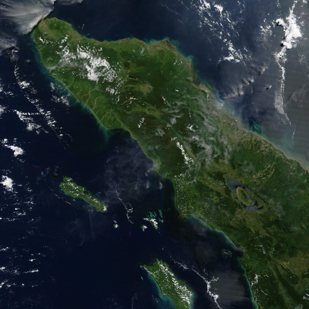
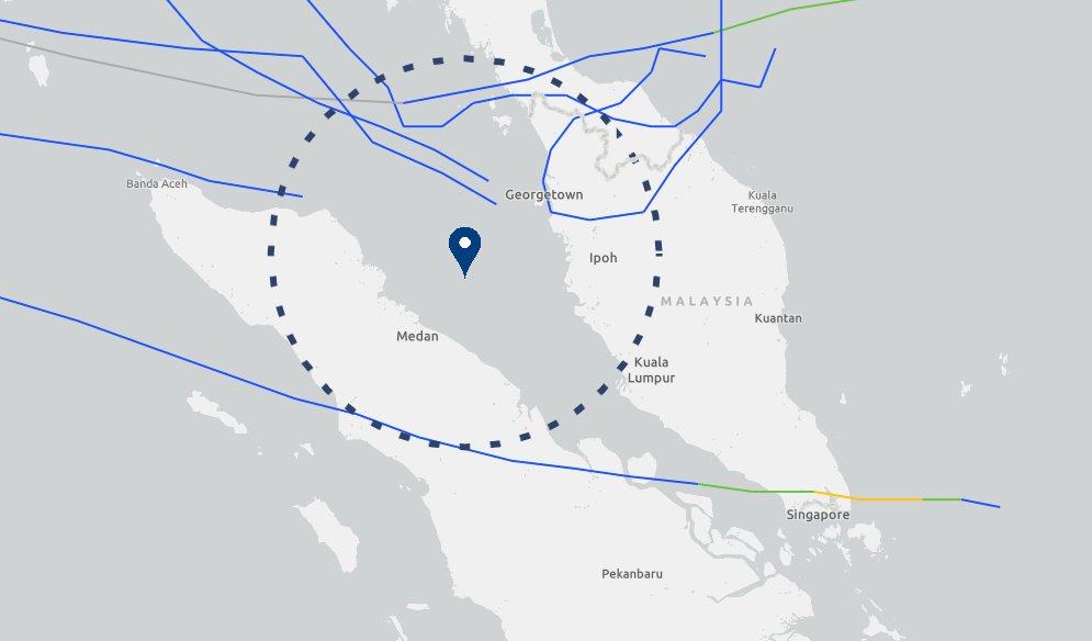
In an unprecedented and an almost impossible meteorological feat, a tropical cyclone was formed in the Malacca Strait — east of Aceh province in #Sumatra Island yesterday, November 25, 2025.
Based on the forecast of the US Joint Typhoon Warning Center (JTWC), Tropical Cyclone #04B is expected to make landfall in the said province later today.
TC 04B could become the first tropical cyclone to make landfall in Sumatra Island for the month of November since the beginning of reliable records, and second overall — after Typhoon #Vamei in 2001.
📷: JTWC #Indonesia 🇮🇩






![Indiametdept's tweet photo. (A) Cyclonic Storm "Senyar" [Pronunciation: 'Sen-yar'] over coastal areas of northeast Indonesia
The #cyclonic_storm #Senyar [Pronunciation: 'Sen-yar'] over Strait of Malacca and adjoining Northeast Indonesia moved west-southwestwards with a speed of 13 kmph in past 6 hours and crossed Indonesia coast near 4.9°N between 0730-0830 hours IST with wind speed of 70-80 kmph gusting to 90kmph, and lay centered at 0830 hours IST of today, the 26th November, 2025 over coastal areas of northeast Indonesia near latitude 4.9°N and longitude 97.8°E, about 80 km east of Kuta Makmur (Indonesia), 280 km west of George Town (Malaysia), 580 km southeast of Nancowry (Nicobar Islands) and 730 km southeast of Car Nicobar (Nicobar Islands).
It is very likely to continue to move west-southwestwards and maintain the intensity of cyclonic storm till 27th early morning. Thereafter, it is very likely to recurve eastwards with gradual weakening during subsequent 24 hours.
(B) Well Marked Low pressure area over southwest Bay of Bengal and adjoining areas of Southeast Sri Lanka & Equatorial Indian Ocean
The Well marked low-pressure area over southwest Bay of Bengal and adjoining areas of Southeast Sri Lanka & Equatorial Indian Ocean persisted over the same region at 0830 hours IST of today, the 26th November, 2025.
It is very likely to move nearly north-northwestwards and intensify into a depression during next 24 hours. Thereafter, it is very likely to intensify further and continue to move north-northwestwards across southwest Bay of Bengal towards North Tamil Nadu & Puducherry coasts during subsequent 48 hours.](https://pbs.twimg.com/media/G6qUeFhawAAI-kX.png)












![Indiametdept's tweet photo. (A) Cyclonic Storm "Senyar" [Pronunciation: 'Sen-yar'] over coastal areas of northeast Indonesia
The #cyclonic_storm #Senyar [Pronunciation: 'Sen-yar'] over Strait of Malacca and adjoining Northeast Indonesia moved west-southwestwards with a speed of 13 kmph in past 6 hours and crossed Indonesia coast near 4.9°N between 0730-0830 hours IST with wind speed of 70-80 kmph gusting to 90kmph, and lay centered at 0830 hours IST of today, the 26th November, 2025 over coastal areas of northeast Indonesia near latitude 4.9°N and longitude 97.8°E, about 80 km east of Kuta Makmur (Indonesia), 280 km west of George Town (Malaysia), 580 km southeast of Nancowry (Nicobar Islands) and 730 km southeast of Car Nicobar (Nicobar Islands).
It is very likely to continue to move west-southwestwards and maintain the intensity of cyclonic storm till 27th early morning. Thereafter, it is very likely to recurve eastwards with gradual weakening during subsequent 24 hours.
(B) Well Marked Low pressure area over southwest Bay of Bengal and adjoining areas of Southeast Sri Lanka & Equatorial Indian Ocean
The Well marked low-pressure area over southwest Bay of Bengal and adjoining areas of Southeast Sri Lanka & Equatorial Indian Ocean persisted over the same region at 0830 hours IST of today, the 26th November, 2025.
It is very likely to move nearly north-northwestwards and intensify into a depression during next 24 hours. Thereafter, it is very likely to intensify further and continue to move north-northwestwards across southwest Bay of Bengal towards North Tamil Nadu & Puducherry coasts during subsequent 48 hours.](https://pbs.twimg.com/media/G6qUeFlaAAA8_Np.jpg)