Official Twitter account of the Chief Meteorologist at WCBD-TV in Charleston, SC. NATAS Silver Circle 2017. Order of the Palmetto 2006. SCBA Masters Award 2025
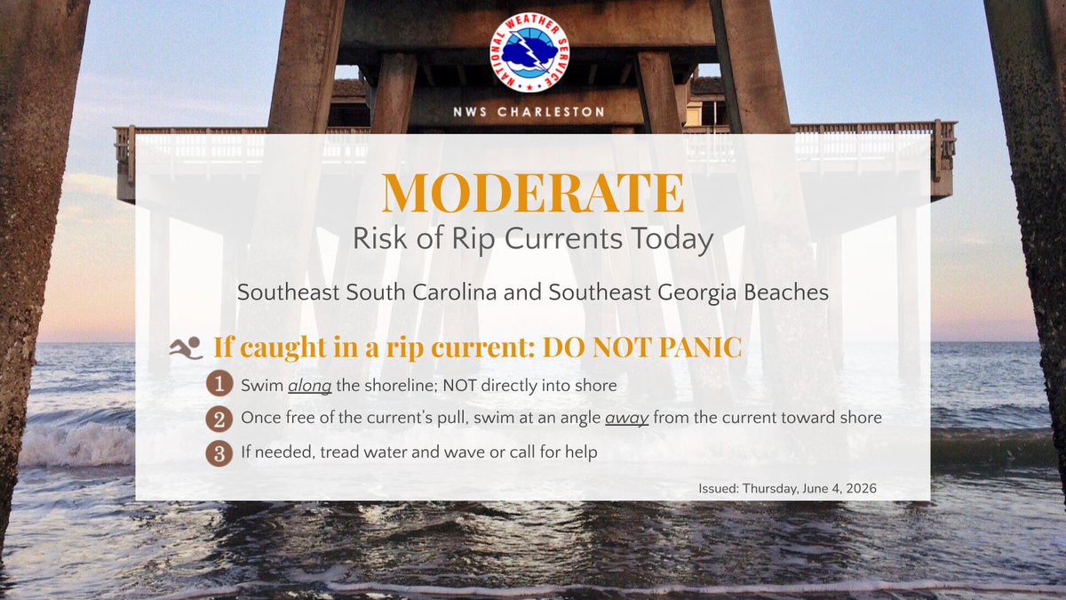
Heads up beachgoers - a moderate risk of rip currents will be possible today at all southeast South Carolina and Georgia beaches!
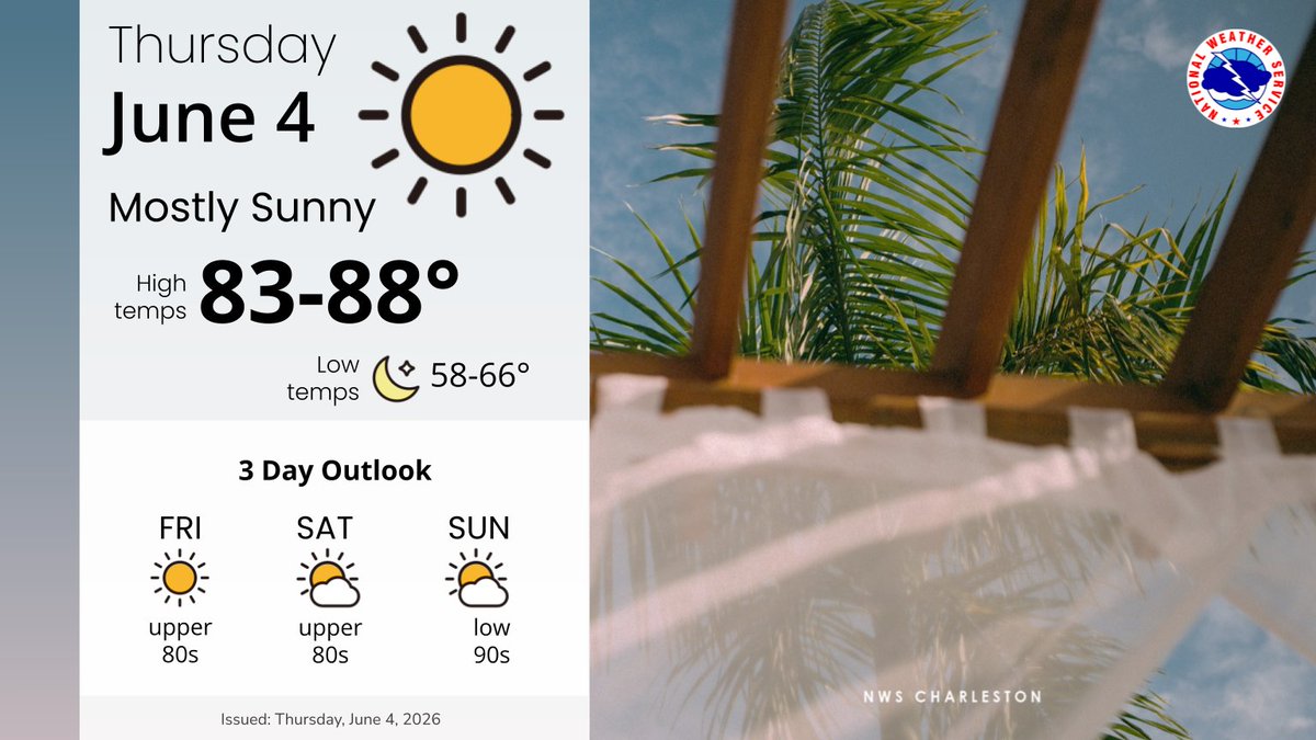
Otherwise, look for quiet conditions to continue into the weekend, with highs gradually warming into the lower 90s under mostly sunny skies.
It's a Lunch Outside Alert Day on Thursday, June 4th!
Enjoy lots of sunshine, lighter winds, and temps in the upper 70's to mid 80's during lunchtime!
High tomorrow....86 degrees!
A beautiful night ahead, with temps falling into the upper 60's by 10pm. We expect another morning in the 50's and low 60's. Tomorrow's high will be a few degrees warmer than today...reaching the mid 80's.
Hour by Hour Forecast for Wednesday/Thursday (6-3,6-4)
Looking forward to seeing everyone on Saturday! I will be there from 10am until Noon. Come by and say hello! Lots of great information to get prepared and ready for whatever this hurricane season may bring!!!
@WCBD@StormTeam2WCBD@ChasCountyGov
Here is our Tuesday (6-2) Hour by Hour Forecast…after seeing quite a bit of rainfall on Mon, today will be overall drier.
There is a little bump in the chance of rain late morning and early afternoon, so we will be watching radar trends.
Cooler today, with highs in the 70’s
Heavy rainfall moving into an area which received significant rainfall earlier today, in addition to a high tide, has prompted the issuance of a Flash Flood Warning for parts of Berkeley, Dorchester, and Charleston Counties.
Flash Flood Warning Until 12:15am Tuesday (6-2)
We are still tracking a cluster of strong thunderstorms with heavy rainfall moving SE across the area, just entering upper Berkeley Co. as of 8:30pm Monday. Be alert for these storms as they move in over the next 2-3 hours.
VIPIR Radar as of 8:30pm Monday (6-1)
Radar UPDATE as of 10:45am…..A few showers still around this Monday morning (6-1) and into the afternoon. Keep the umbrellas at the ready. Most areas should stay dry for the majority of the day.
@StormTeam2WCBD@WCBD
We're watching heavy downpours along the coast, and into the Atlantic Ocean. Rain moves over the immediate Charleston area over the next couple of hours, with the heaviest rainfall along the beaches, from Folly Beach to the Isle of Palms.
VIPIR Radar as of 10:50pm Sunday (5-31)
The “Blue Moon” rising tonight! The 2nd full moon in a calendar month is referred to as a Blue Moon. Thanks @dollydroze for this photo over Downtown Charleston. We also had a full moon on the 1st of May.
@StormTeam2WCBD@WCBD
Some life news. I have officially retired from the NWS. It was time to move on. I haven’t completely left the field as I will be teaching for the College of Charleston this fall, but no more shift work!
Radar Update as of 2:30pm Saturday shows a few showers and thunderstorms are moving from the midlands toward the coast this Saturday afternoon. Most of us will stay dry, but we will see a few heavier downpours in the next few hours.
@WCBD@StormTeam2WCBD
Weather was perfect for the Floppin Flounder 5k on Sullivan’s Island this Saturday Morning. Thanks Chief Anthony Stith for the video!
1200 people took part in the run/walk, benefitting the Sullivan’s Island Fire & Rescue Dept, Charleston Running Club, and other local charities.
Radar Update for Saturday Morning, May 30th, as of 7:30am….isolated showers will be moving through at times this morning, with coverage of rain expected to increase as the day goes on.
Still going to stick to original forecast of no washout, but keep the umbrellas handy!