@SCSU_Weather is hosting a FREE, VIRTUAL Northern Plains Weather Workshop this Thursday (3:00-6:00 PM) and Friday (1:30-5:30 PM). Come hear some awesome talks given by students and scientists from the NWS! All are welcome to attend. DM for details on how to register.
The @NWSTwinCities-SCSU Skywarn training on the @stcloudstate campus, Wick Science Building Rm 114, will now be taking place from 5-8 PM on 23 April. Hope you can join us! DM for additional details as needed.
Tonight's Skywarn training session has been *POSTPONED* due to weather. Be sure to check in with @NWSTwinCities for their updated list of still-available training sessions. We hope to welcome folks here later this semester for a make-up training!
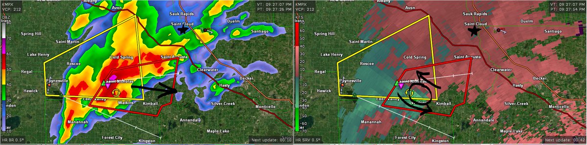
A #tornado warning is in effect for far southern and southeastern portions of Stearns County. The area of rotation (black circle in right panel) will pass well south of @stcloudstate campus. 2" diameter hail is also possible with the storm. Additional storms thru 10:30pm. #mnwx
Honored to be selected as a Climate Change @AAAS_STPF Fellow within the U.S. Agency for International Development 🌍 (@USAIDAfrica@USAID)
Appreciating prior STEM training & great teams from @stcloudstate@Scripps_Ocean@JHUEPS, & excited for fellowship orientation next week!
There is still a lot of uncertainty, but this weekend's system warrants monitoring, especially if you are in Central MN. Be sure to follow @NWSTwinCities for up-to-date information that can help you stay safe.
This weekend's system is still on track to pack a punch. The exact track of the low will determine where the divide between snow, mixed precipitation, & rain sets up.
This forecast will change as new data is received. As always, stay tuned for updates!
#MNwx#WIwx
Want to share your precipitation and snowfall measurements with the National Weather Service? Join @CoCoRaHS! Sign up today at https://t.co/1VUih6ZpbQ .
Additional information about network, including where new observers are especially needed: https://t.co/zBH2ykyQv7
#mnwx#wiwx
🚨 Attn students 🚨 There are just a few days left to apply to the (paid) MRCC Summer Intern program. You'll gain hands-on experience in climate data services helping us fill data requests, conduct outreach & maybe a research project too. Don't miss this opportunity! ⏰
"Okay, campers, rise and shine! And don't forget your booties 'cause it's cooooooold out there today!"
And, according to our very own @NWSTwinCities, it's going to be cooooooold tonight, too. Better bundle up.
A SEVERE THUNDERSTORM WARNING is in effect for communities west and southwest of St. Cloud and SCSU Campus until 7:30PM. This radar image depicts small hail falling near Saint Martin and is heading towards Sartell. Seek shelter until severe weather threat passes (by 9PM.)
Today is #SafePlaceSelfie Day! Here at @stcloudstate we found our safe place from extreme weather! Do you know where your safe place is at home and/or work when severe weather strikes?
We'd like to extend a warm welcome to @MattV413wx, who will be joining the rest of our AHS departmental faculty in the Fall 2021 semester. Welcome aboard! 😊👍
Due to frigid temperatures and wind chill, St. Cloud State will be operating remotely both in St. Cloud and Plymouth on Friday, Feb. 12. Classes will be delivered remotely or cancelled. See your email or https://t.co/F59PFHFzxe for more details.
Due to frigid temperatures and a wind chill advisory, @stcloudstate and St. Cloud State at Plymouth will be operating remotely between 8-11 a.m. Feb. 9. Classes will be delivered remotely or cancelled. Learn more at https://t.co/F59PFHFzxe
Meteorology and hydrology students are preparing for a field adapting to new technologies expanding possibilities in weather and river forecasts. Read all about it in the cover story of the latest issue of St. Cloud State Magazine. #BHuskiesPROUD
https://t.co/7lWRptzgzm
Heads-up: If you are in this area, be sure to remain alert for changing weather conditions throughout the day and always have multiple ways of obtaining information to stay as safe as possible.
The best chance for severe thunderstorms later today is expected from southern Minnesota/northern Iowa into central Wisconsin. Damaging wind gusts, large hail, and a couple of tornadoes are possible. #MNwx#WIwx#IAwx