👋 Are you following us on LinkedIn?
Simply scan the code, or click the link below, to join us there for more in depth and specialised content as we head into 2024.
https://t.co/849i4GBsNO
🌟 Happy New Year 🌟 We look forward to supporting more of your incredible innovations in 2024.
Don't forget to follow us on LinkedIn to keep up with all our latest news and funding opportunities.
➡️ https://t.co/849i4GBsNO
📢 DEADLINE EXTENDED ⏰ You have until 15 January to submit your proposal for: ‘The Sustainable Transformation of Agriculture Through Digitalisation and Space’. We're calling for ideas for Demonstration Projects enabled by space technologies. Apply now ➡ https://t.co/y1I9xBr7dH
🎄 Season’s Greetings from all of us at ESA Space Solutions. We wish you a happy and restful winter break.
Don't forget to follow us on LinkedIn to keep up with all our latest news and opportunities in 2024.
➡️ https://t.co/849i4GC0Dm
📢 FUNDING OPPORTUNITY: ‘Diversity, Equity and Inclusion’. From the provision of detailed data about the physical environment, to advanced data modelling and analytics, space-enabled services can help address accessibility and inclusivity challenges. ➡ https://t.co/wnpeVDq5wv
📢 NEW for 2024 🤖 Call for proposals: 'Commercial Applications of Space-Enabled Robotics'.
There have been remarkable advances in robotics technology in recent years, pushing the boundaries of the possible. Breakthroughs in robotics have resulted in enhanced autonomy, dexterity, and interaction capabilities of robotic systems and have paved the way for significant growth of the robotics market over the past few decades. Parallel advancements in the space sector mean that satellite technologies now have the capability to enable novel services utilising robotics on Earth and/or augment their capabilities. As such, the opportunity exists to incorporate robotics and satellite technology to create new commercial services and add value.
In 2024, we’d like to hear your ideas for Feasibility Studies and Demonstration Projects that bring together robotics and space data or technologies to tackle challenges faced across a range of industries, including manufacturing, healthcare, critical infrastructure, agriculture, and logistics, among others, which could not otherwise be addressed effectively.
Find full details ➡ https://t.co/Napf8VAH8k
#Robotics #RoboticsTechnology #RoboticsInnovation #RoboticsEngineering #RoboticSolutions #RoboticAutomation #RoboticSystems #RoboticsIndustry
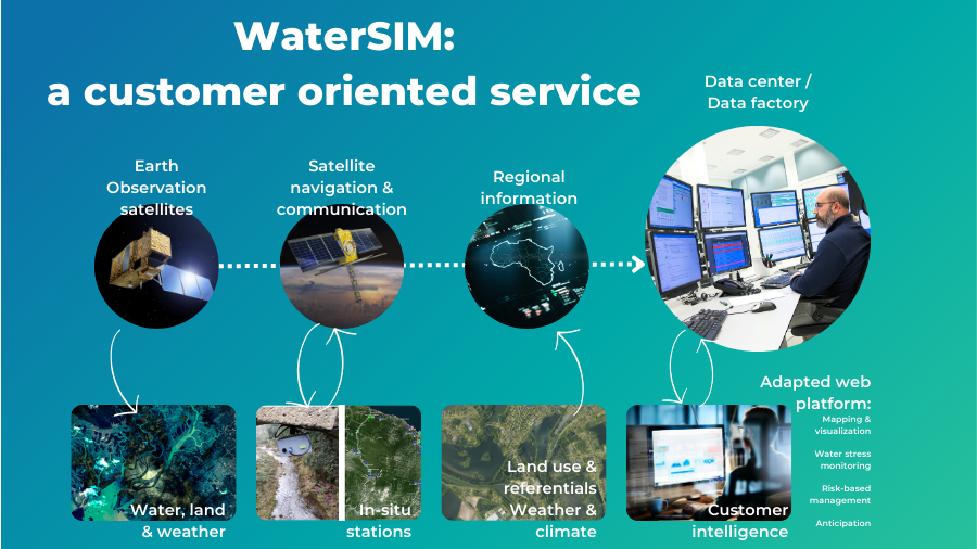
💧 To meet the current and future challenges around water availability and usage, it is essential that water sector players monitor the quantity and quality of surface water using indicators dedicated to their needs. This monitoring is key to defining water accessibility, availability and usage conditions.
@CLS_Group and @vortex_io have joined forces to provide an innovative, reliable and efficient solution - thanks to the synergies of space and in-situ data. By combining the data from these technologies and regional information, their 'WaterSIM' service will provide support to decision-makers, offering high added-value services through a single dedicated web platform which is adapted to customer needs. These include:
• Real-time acquisition of available volumes, water bodies, and water course levels
• Monitoring of withdrawals and usage
• Risk management (drought, flood and pollution) and alerts
• Anticipation of water availability failures
Ulrick Mondongue, Satellite Telemetry – Air, Hydrology & Pollution tracking at CLS Group said: “We are delighted to be working closely with ESA and the CEO Water Mandate to accelerate progress in tackling the global water crisis. Our joint efforts aim to have a significant and positive impact on the challenges posed by this urgent issue.”
WaterSIM was announced as one of the first batch of Feasibility Studies selected for support through the ‘Digitising Water Resilience Monitoring in Basins’ initiative, offered under @ESA's Business Applications and Space Solutions programme in partnership with the CEO Water Mandate’s Water Resilience Coalition.
Find out more about WaterSIM ➡ https://t.co/UDdl5rMmfW
📷 CLS Group, vorteX-io - WaterSIM architecture system.
@PacificInstitut@H2O_stewards #WaterResilienceCoalition #WaterResilience
CLOSING SOON 🚴 @esa is speaking to #Tourism stakeholders, including @visitflanders, to identify cases where space solutions could help measure tourist flow. Could you develop a service to monitor #OverTourism, for example, by tracking busy cycling routes?
https://t.co/lTzy8pmBh9
📢 DEADLINE EXTENDED: 'Space for Infrastructure – ENERGY’. You now have until 26 Jan 2024 to submit your idea for a Feasibility Study or Demonstration Project that uses satellite technology or data in an innovative service or application for the Energy Sector.
The safety and protection of critical #EnergyInfrastructure - the physical structures and networks that are used to transport and store energy, including power plants, transmission lines and pipelines - is an increasing focus as nations look to secure their energy futures. Satellite Communications, Global Navigation Satellite Systems and Satellite Earth Observation all have an important role to play in securing our key #infrastructure, which requires a combination of in-situ and large-scale observation tools to ensure continuous and reliable monitoring.
Find full details and apply now ➡ https://t.co/Bn7Xo25CA6
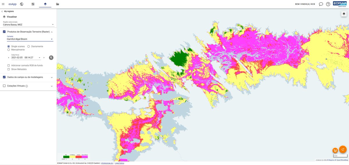
💧 ‘DITCH’ - Digital Twin Catchment – is a digital twin of water basins by @EOMAP. The future solution will help companies and organisations reduce their water footprints by identifying the impact of water resilience measures and thus guide decision making.
It is part of the first batch of Feasibility Studies under the ‘Digitising Water Resilience Monitoring in Basins’ initiative, offered under the European Space Agency - ESA's Business Applications and Space Solutions programme in partnership with the CEO Water Mandate’s Water Resilience Coalition (WRC).
In the framework of DITCH, EOMAP will create virtual water bodies to behave as closely as possible to their real-world counterpart. This will feature key static and dynamic variables of water bodies, integrated into a multi-source approach comprised of:
• satellite-derived water parameters
• hydrological modelling data
• field data
Karin Schenk, Head of Water Quality at EOMAP said: “Global warming puts more and more stress on water reservoirs. Digital twins can visualize and help reduce this stress. Using multi-source data from physical twins, we can simulate or even predict the behaviour of aquatic environments in real-time. This can, for example, lead to improved withdrawal schedules avoiding potentially harmful algae blooms. DITCH will also be a great tool to measure the impact of nature-based solutions on water bodies. Cooperating with ESA and WRC will allow us to team up with companies committed to such dedicated water actions.”
DITCH is being developed in Germany. Find out more about EOMAP’s water quality monitoring services ➡ https://t.co/YeBfnJHFeQ
📷 EOMAP - Cahora Bassa Reservoir on the Zambezi River in Mozambique: EOMAP’s eoApp Aqua shows potentially harmful algae blooms (HAB).
@PacificInstitut@H2O_stewards
#eomap #detectmore #hydrospatial #AlgaeBlooms #DigitalTwin #WaterMonitoring #WaterStewardship #WaterStewards #WaterLeadership #WaterResilience #CEOWaterMandate #WaterResilienceCoalition
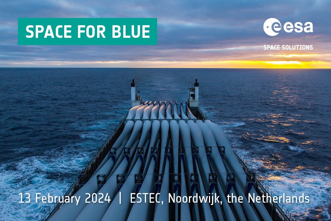
🆕 Register your interest for ''Space for Blue''. Join us to explore the possibilities that lie at the intersection of the space and maritime sectors.
Key stakeholders from the maritime sector and beyond will come together to discuss the challenges across four key areas:
• Maritime Safety and Security
• Maritime sustainability
• Blue Natural Capital
• Blue Energy
The event, which will focus on addressing the specific challenges faced by North and Baltic Seas stakeholders, will connect users and service providers to discuss how challenges in the four subject areas can be tackled effectively using space-based solutions.
The event is free to attend but spaces are limited and will be allocated on a first come, first served basis.
📅 Tuesday 13 February 2024, 09.00 - 18.00 CET, @ESA ESTEC, Noordwijk, the Netherlands.
Register now ➡ https://t.co/83Mvmo41JM
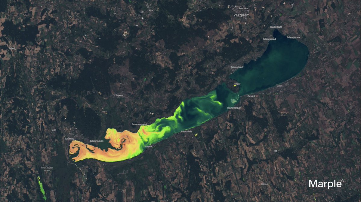
🗺 German start-up Marple uses machine learning to intelligently observe the Earth. At @COP28_UAE their project 'WARM' - Water Resilience Map – was announced as one of the first batch of Feasibility Studies selected for support through the ‘Digitising Water Resilience Monitoring in Basins’ initiative, offered under @esa's Business Applications and Space Solutions programme in partnership with the CEO Water Mandate’s Water Resilience Coalition.
WARM is an interactive web-based map that uses satellite data and machine learning to assess a region's water stress based on three criteria: water availability, water quality, and water accessibility.
"Water stress is not universally definable but varies from region to region. Some areas grapple with excess water, others with scarcity or insufficient quality. Our goal is to train an algorithm to identify and potentially predict water stress based on the local conditions. For this, we rely on high-quality satellite data and insights from local resilience programs. We are therefore excited to be working with ESA - European Space Agency and the CEO Water Mandate on this innovative project.” — Dr. David Scherf, Co-founder Marple.
Find out more about Marple ➡ https://t.co/ljCQcMFgya
📷 Marple, 'WARM' - Water Resilience Map.
#COP28UAE #COP28 #WaterResilience #WaterMonitoring #WaterScarcity #CEOWaterMandate #WaterResilienceCoalition @PacificInstitut@H2O_stewards
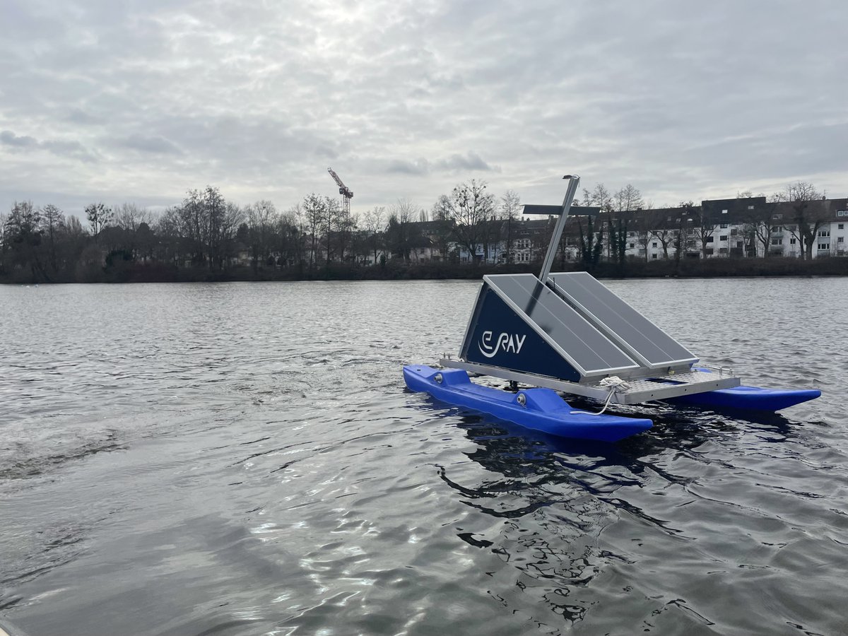
💧 ‘SWIM’ – ‘Surface Water Information Management' - is a water monitoring and management system developed by e.Ray Europa GmbH which provides real-time monitoring for our waters. The system uses the latest techniques for measuring water parameters, combined with data from Earth observation satellites to closely monitor coastal areas, rivers and lakes. Continual monitoring and real-time alerts mean that swift countermeasures can be taken, driven by reliable data, to safeguard vital aquatic habitats.
SWIM was selected in the first batch of Feasibility Studies announced during @COP28_UAE under the ‘Digitising Water Resilience Monitoring in Basins’ initiative. The initiative, offered as part of @ESA's Business Applications and Space Solutions programme in partnership with the CEO Water Mandate’s Water Resilience Coalition, aims to support digital and space technology partners to develop water resilience monitoring capabilities.
Fabían Rolando Suarez Quevedo, Co-Founder and Chief Operating Officer of e.Ray Europa GmbH said: "The 'Digitising Water Resilience Monitoring in Basins' initiative is a beacon of hope for water management. 'SWIM' exemplifies the power of data and technology in preserving our planet's vital water bodies."
Find out more about ‘SWIM’ for sustainable water management ➡ https://t.co/yN4y8KkFSM
#COP28UAE #COP28 #CEOWaterMandate #WaterResilienceCoalition #WRC @PacificInstitut@H2O_stewards
💧 ‘Data4Water’ is a Feasibility Study for digitising the Godavari River basin in India, conducted by BWI - Blue Water Intelligence, a French startup specialising in the digitisation of river basins.
Globally, 70% of freshwater is used for agriculture. After engaging with communities along the Godavari River, Data4Water identified that farmers need to pump water from the rivers and fill their water tanks when the discharge is above the seasonal average. They put forward a business case and proof of concept that uses Earth Observation data to more effectively monitor, measure and manage water reserves. The proposed solution will not only benefit the Godavari river, but will help to tackle this challenge around the world.
Data4Water was announced as one of the first Feasibility Studies in a batch to be supported under the ‘Digitising Water Resilience Monitoring in Basins’ initiative, offered through @ESA's Business Applications and Space Solutions programme in partnership with the CEO Water Mandate’s Water Resilience Coalition, recently announced at COP28 UAE.
Find out more about BWI ➡ https://t.co/I8B1n9zqs6
📷 BWI
#COP28UAE #COP28 #RiverBasins #WaterBasins #WaterResilienceCoalition #WaterResilience
@PacificInstitut@H2O_stewards
⚡ We're calling for ideas for Feasibility Studies and Demonstration Projects for applications and services that use satellite technology or data in innovative solutions for the Energy Sector. The safety and protection of critical energy infrastructure has become an increasing focus for nations looking to secure their energy futures. The physical structures and networks that are used to transport and store energy, including power plants, transmission lines and pipelines, require a combination of in-situ and large-scale observation tools to ensure continuous and reliable monitoring. 'Space for Infrastructure – ENERGY’, submit your proposal ➡ https://t.co/Bn7Xo25CA6 #EnergyInfrastructure #EnergyTransformation #EnergyTransition #GreenEnergy #SustainableEnergy #Infrastructure
🆕 Uranus pic just dropped!
This NASA/ESA/CSA James #Webb Space Telescope image gave a stunning view of the unusual and enigmatic Uranus, an ice giant that spins on its side.
Webb managed to capture this dynamic world with its rings, moons, storms, and other atmospheric features — including a seasonal polar cap!
��� Agreed Earth’s Nitrogen Flow Model allows farmers to monitor and connect the impact of nitrogen losses to their bottom line. Nitrogen is a significant source of agricultural pollution and emissions. The UK-based company uses geospatial analytics and machine learning to measure nitrogen loss and improve the ability of farms to accurately report on environmental impact, while at the same time providing essential data to support the transition to more sustainable farming practices.
A high proportion of the nitrogen used in farming is lost through run-off from fields. @ESA is working with Agreed Earth under the ‘Digitising Water Resilience Monitoring in Basins’ initiative, as part of ESA's Business Applications and Space Solutions programme, in partnership with the CEO Water Mandate’s Water Resilience Coalition, to support companies who are developing water resilience monitoring capabilities. Agreed Earth’s Nitrogen Flow Model has been selected in the first batch of Feasibility Studies under this initiative and announced during @COP28_UAE.
Find out more about Agreed Earth ➡ https://t.co/kHXSbYDRrY
📷 Agreed Earth - high level view of the model.
#COP28UAE #COP28 #Nitrogen #PollutionMonitoring #EmissionsMonitoring #SustainableFarming #SustainableAgriculture #WaterResilienceCoalition #WaterResilience @PacificInstitut @H2O_stewards
🌟 French company @MurmurationSas has been awarded a coveted @ESA Rising Stars award for its environmental monitoring service, which uses space technology to mitigate the growing environmental footprint of global tourism.
Devised under ESA’s Business Applications and Space Solutions (BASS) programme, the pioneering service harnesses satellite data to provide vital information about a wide range of aspects from air quality and vegetation health to tourist flow.
This comprehensive solution will provide precise, up-to-date data on travel destinations across the globe, which will not only help to promote environmental responsibility but also boost sustainable economic activity within the tourism sector by locating the most sustainable areas for investment and development.
Guillaume Prigent, ESA’s Technical Officer who has worked closely with Murmuration on the project, says “This venture shows how combining space technology with a great business idea can lead to significant commercial and sustainability returns. We are delighted to see Murmuration receiving an ESA Rising Stars award and look forward to seeing the service grow and expand into new markets.”
Read more ➡ https://t.co/sRVBPhxAyU
#SustainableTourism #SustainableTravel
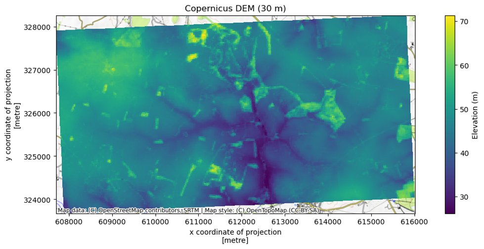
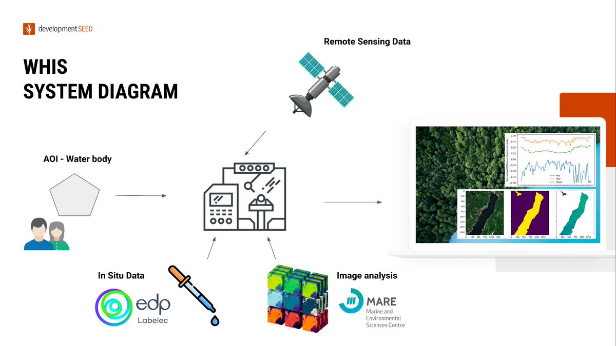
💧 @developmentseed, Portugal, is working with @ESA's Business Applications and Space Solutions programme in partnership with the @H2O_stewards' #WaterResilienceCoalition to lead the development of an API Service that takes data from multiple open-data satellites to provide a continuously updated information stream about the environmental health of inland water bodies. The service will enable private sector and public agencies to track a set of specialised and highly descriptive Water Health Indicators.
The project is one of the first batch of Feasibility Studies under the ‘Digitising Water Resilience Monitoring in Basins’ initiative announced during @COP28_UAE.
Read more about the Feasibility Study ➡️ https://t.co/qXoAkYlSxN
Find out more about Development Seed ➡️ https://t.co/Psuvv7hHV6
#COP28UAE #COP28 #WaterStewardship #WaterStewards #WaterLeadership #CEOWaterMandate @PacificInstitut
CLOSING SOON... 🐢 'Space for Tourism'. @ESA is in discussions with key stakeholders in the tourism industry, including @WWF_Deutschland, to identify use cases where space technologies could support innovative solutions for the sector. How could our funding support the development of your application or service to monitor tourism activity and measure its impact on wildlife, biodiversity and conservation?
We're calling for Feasibility Studies and Demonstration Projects from businesses of any size. If your proposal addresses 5G terrestrial and satellite communication networks, you will have the opportunity to test your solution in the 5G/6G Hub at our ECSAT facility on Harwell Science and Innovation Campus, UK.
Submit your proposal ➡ https://t.co/LnF2U8AysU
✈ ATMOSPHERE, a company providing satellite connectivity solutions to the #aerospace sector, has developed a pioneering system that brings cutting-edge services to aerial work operators. Created under the ESA Space Solutions programme, the system uses satellite connectivity to offer real-time information exchange and boost flight mission efficiency.
Satellite Communications are central to the overall system architecture of the service, providing the link between onboard and ground segments during flights and offering global in-flight connectivity. Satellite Navigation provides essential carrier tracking and geo-location, while Earth Observation transmits real-time weather monitoring during operations.
Arnaud RUNGE, European Space Agency - @esa Technical Officer for the project, who also holds a commercial pilot licence, said: “ATMOSPHERE’s new system has all the hallmarks of a game-changing solution for aerial flight missions. With ESA’s support, it offers enhanced technological capability, improved performance levels and an array of pioneering features. […] I am confident it will have a significant impact on the sector.”
➡️ https://t.co/G0qKodiZgs
#AerospaceInnovation













![Space4Europe's tweet photo. ✈ ATMOSPHERE, a company providing satellite connectivity solutions to the #aerospace sector, has developed a pioneering system that brings cutting-edge services to aerial work operators. Created under the ESA Space Solutions programme, the system uses satellite connectivity to offer real-time information exchange and boost flight mission efficiency.
Satellite Communications are central to the overall system architecture of the service, providing the link between onboard and ground segments during flights and offering global in-flight connectivity. Satellite Navigation provides essential carrier tracking and geo-location, while Earth Observation transmits real-time weather monitoring during operations.
Arnaud RUNGE, European Space Agency - @esa Technical Officer for the project, who also holds a commercial pilot licence, said: “ATMOSPHERE’s new system has all the hallmarks of a game-changing solution for aerial flight missions. With ESA’s support, it offers enhanced technological capability, improved performance levels and an array of pioneering features. […] I am confident it will have a significant impact on the sector.”
➡️ https://t.co/G0qKodiZgs
#AerospaceInnovation](https://pbs.twimg.com/media/F_jBfzTW0AA2MX5.jpg)


