Crisis Cleanup has been activated and may be able to help those affected by this Winter Storm. Call 844-965-1386 for free assistance!
Please note, due to overwhelming need, service cannot be guaranteed.
If you're outside tonight please make sure you're safe. Windchill at 11pm... -12º according to the HRRR. Extreme Cold Warning in place until Noon on Tuesday. Warming shelter info for both counties below.
https://t.co/aGA2gKCSqt
https://t.co/HxGP3LpEav
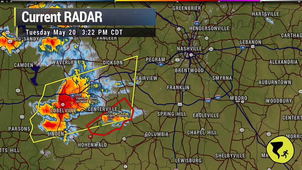
345-515 PM storms moving in from SW. One an expiring Tornado Warning. Other is a maturing, organizing supercell that will demand your attention during dismissal and rush hour. Do not be caught in a car as this comes through. Storms may "turn right" on us so ETAs are irresponsible. / 330 PM
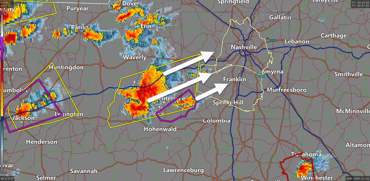
Please hear me when I say to pay attention. This storm in Perry Co has the potential to strengthen as it moves our way. Both Davidson and Williamson Counties need to stay engaged to this. Clean out your safe place. Be where you're going to be. Stay tuned for warnings. I don't like the look it's taking on. 3:22 pm
The good news tomorrow is that moisture appears scant and low level shear kinda meh. Can’t totes rule out tornado but tornado is unlikely and this looks like a wind-hail event. All hazards low probability. Blog out later.
Whites Creek in Bordeaux has also crossed into Action Stage. Stage is 14 ft. At 13 ft, water inundates the backyards of homes along Hamilton Ave in the Bordeaux area.
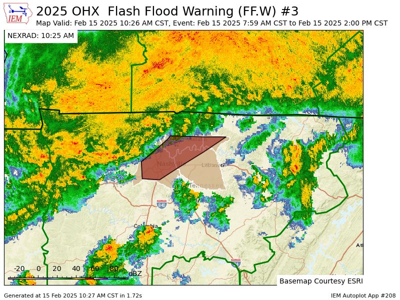
New Flash Flood Warning for NW Davidson Co.
* Until 130 PM CST.
* At 1021 AM CST, Doppler radar indicated thunderstorms producing heavy rain across the warned area. Between 1 and 2.5 inches of rain have fallen. Additional rainfall amounts of 2 to 3 inches are possible in the warned area. Flash flooding is ongoing or expected to begin shortly.
HAZARD...Flash flooding caused by thunderstorms.
SOURCE...Radar.
IMPACT...Flash flooding of small creeks and streams, urban areas, highways, streets and underpasses as well as other poor drainage and low-lying areas.
* Some locations that will experience flash flooding include...Dickson, Ashland City, Waverly, Camden, Erin, White House, Millersville, Greenbrier, Coopertown, New Johnsonville, Ridgetop, McEwen, Tennessee Ridge, Joelton, Pleasant View, Charlotte, Vanleer, Cumberland City, Slayden and Cunningham.
PRECAUTIONARY/PREPAREDNESS ACTIONS...
Turn around, don't drown when encountering flooded roads. Most flood deaths occur in vehicles.
Be aware of your surroundings and do not drive on flooded roads.
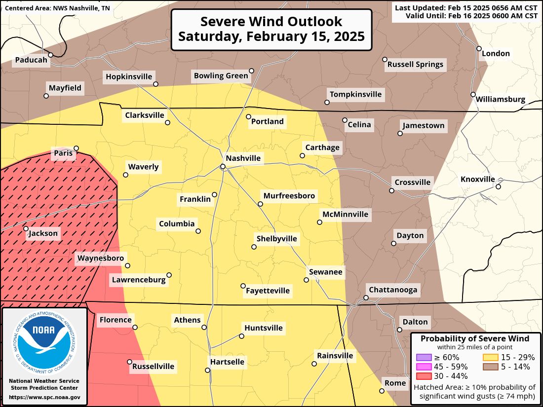
With this line, there is a 5% chance of a tornado, and a 15% chance of damaging winds within 25 miles of you. We are not included in the large hail risk. This line of storms should arrive around 11 pm, give or take a couple of hours. We'll refine the ETA as it drives in. (3/5)
HRRR thinks additional scattered rain will move through throughout the day with some breaks. Then, our attention turns to severe weather mode with a line of storms sweeping through tonight. (2/5)
Most of Davidson and Williamson look to get a needed break for a bit, so let's catch up. A flash flood warning is in effect for most of Davidson until 11am. Creeks like Browns, Dry, Whites, Richland, etc are running high, but at this moment are below flood stage. That could change. (1/5)
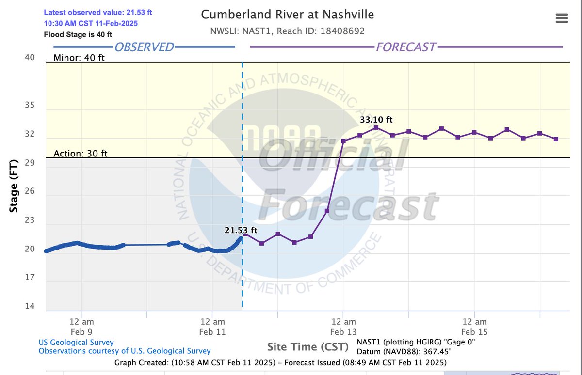
The Cumberland River is forecast to stay below flood stage, but reach action stage over the coming days as rain water makes its way down the Cumberland River system. If this happens, expect water around the riverfront landing and recreation areas near Nissan Stadium.
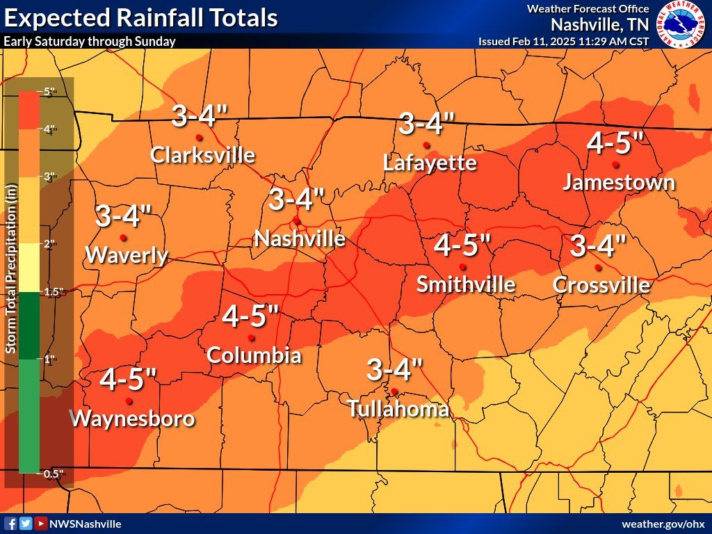
The "main event" of this stretch of rainy days appears to be Saturday, when NWS is forecasting 3-5 inches of rainfall in our two counties. If you live in or near a designated flood plain or in a place that has flooded before, *heads up*. Between now and Saturday, make preparations in case water threatens your home.
New: Cold Weather Advisory
* WHAT...Very cold temperatures in the single digits and wind chills as low as 5 below expected.
* WHERE...Across Middle Tennessee.
* WHEN...From 6 PM Sunday to noon CST Monday.
* IMPACTS...The cold wind chills as low as 5 below zero could result in hypothermia if precautions are not taken.
PRECAUTIONARY/PREPAREDNESS ACTIONS...
Use caution while traveling outside. Wear appropriate clothing, a hat, and gloves.
Snow To Continue Until This Evening, Travel Impacts Expected to Last Into the Weekend.
Not a must-read blog, feel free to just enjoy the snow.
https://t.co/Uw0IGNLJgo
At the noon hour, neighborhood and side streets in Nashville are snow covered and slippery, while the interstates and major thoroughfares, like Old Hickory Blvd & Murfreesboro Pk, have been treated/plowed & are in better shape. If you must drive, please slow down & be careful!


![NashSevereWx's tweet photo. OHX issues Flash Flood Warning [flash flood: radar indicated] for Cheatham, Davidson, Dickson, Hickman, Maury, Rutherford, Sumner, Williamson, Wilson [TN] till Apr 3, 6:15 PM CDT https://t.co/sLCb8OXcAT https://t.co/y9tnwfTfYx](https://pbs.twimg.com/media/GnosqV8WAAATW37.png)