Adults and children in the United States are getting more than 50% of their total calories from ultra-processed foods, according to a new federal report.
https://t.co/oVCsj36ZAX
The deadly mid-air collision at Reagan Airport in January was years in the making, the operations manager of the DCA air traffic control tower on the night of the accident told the National Transportation Safety Board. https://t.co/FN6qzXNmoA
People who stop taking GLP-1 medications like Wegovy and Zepbound started to regain weight in a short amount of time, a new study suggests. https://t.co/OaIVeedZmd
BREAKING: Iranian Foreign Minister Abbas Araghchi says the U.S. is 'fully responsible' for the consequences of its strikes on Iranian nuclear sites, and diplomacy is not an option at the moment. Follow AP's live updates. https://t.co/GNhkLKJyzw
BREAKING: The FDA has ordered Pfizer and Moderna to update the warning labels on their COVID mRNA vaccines to include the risk of heart-related injuries, primarily affecting teenage boys and young men.
An iceberg the size of Chicago that broke off of an Antarctic ice shelf has revealed a thriving ecosystem beneath it, according to researchers. https://t.co/7V2pr3oRx0
Additional rounds of severe weather are expected in the coming days. Severe T-storms expected across the Plains Tuesday afternoon and overnight with a more widespread severe threat likely from the Midwest into the MS Valley on Wed/Wed night.
Severe thunderstorms containing large hail, damaging winds, tornadoes and frequent lightning with heavy rainfall will spread from the Mississippi, Ohio, Tennessee Valleys today then to the East Coast on Monday. It’s important to know the difference between watches and warnings, so you and your family can plan accordingly.
A Tornado WATCH means Be Prepared.
A Tornado WARNING means Take Action!
https://t.co/oTLeEytb9M
A Level 3 of 5 (Enhanced) risk is forecast across portions of the Middle and Lower MS, Lower OH, and TN Valleys on Sunday into Sunday night. Widespread and potentially significant severe storms, including very large hail and a few strong tornadoes, are possible.
The risk for significant ice build up remains overnight tonight through Saturday morning for much of the Upper Peninsula, and extreme northern Lower Peninsula (tip of the mitt).
A couple changes have been made for this last call forecast which is in effect from now through about 2 PM tomorrow afternoon. A lull in the precipitation is expected before precipitation resumes Saturday night. Let's break it down by precipitation type one more time.
Freezing Rain & Ice
Our main concern remains the ice storm set to unfold here in the coming hours. We have expanded our 0.2-0.4" zone further west to encompass some of the central UP counties currently under an Ice Storm Warning. Ensemble averages look to be on the lower end here, but still within the maroon-shaded threshold. We have expanded the black hatched area (0.05" per hour rates) into the M-28 corridor in the eastern UP as we've seen a slight shift north in recent analysis. In northern lower Michigan, most of the ice on this map will fall well after midnight, as the line that will be training over US-2 drops south with the front into Saturday morning. Not all locations in northern lower will see freezing rain, but these are your totals in the event you do. A general reminder for all areas, just because you're in the 0.2-0.4" zone for example, does not mean you'll get the full 0.4".
Snow
No major changes other than a slight shift north. Sleet totals remain mixed in with these snow totals shown. Any significant snowfall will be confined to the Copper Harbor region as daytime highs only reach about 32°F here. No snow expected today in the Lower Peninsula.
Rain
We knocked down the totals for the Lower Peninsula for today. Plentiful rain will still occur, and a couple isolated spots in our T-0.25" zone will exceed 0.25" within any heavy thunderstorm, but confidence in widespread 0.25"+ after these early afternoon thunderstorms here is low.
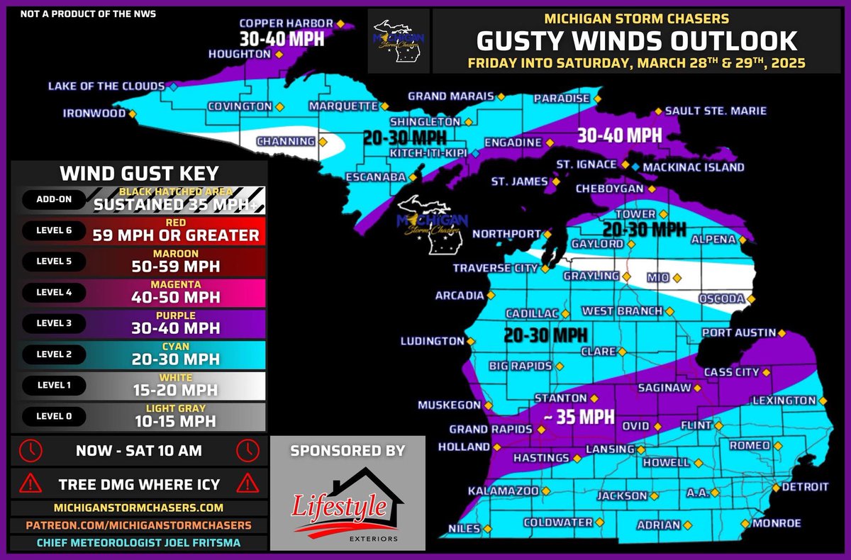
Wind
A narrow corridor of approximately 35 MPH wind gusts is possible from Holland over to the thumb later tonight. 30-40 MPH gusts are still likely in our ice storm region on the east side of the Upper Peninsula, along with the Keweenaw Peninsula. Elsewhere, gusts up to 30 MPH are possible for a decent majority of the state. These winds will pick up gradually as the day turns to night.
A reminder, this is only for this first round. A secondary forecast package for round two will be released late tonight. We plan on hosting another briefing this evening around 7 pm for both systems, and perhaps a glance into the middle of next week.
-- Useful Links --
Our YouTube channel:
https://t.co/xoRIMkyjJy
Our Twitch channel:
https://t.co/qm8gohKt79
Our Merch store:
https://t.co/qB8FFfGTtP
Submit a damage report in our Facebook community group:
Michigan Weather Reports
-- Post Sponsor: Lifestyle Exteriors --
If your home has suffered damage from a storm, we’re here to help. We’ll even take care of the insurance process for you, taking one more thing off your plate. We understand that you have enough to worry about because we’ve been in your shoes. As Michigan natives and homeowners ourselves, we appreciate how important it is to protect your home and your investment in your property.
Is your roof ready for the next storm? Our expert team provides free roofing inspections to ensure your home is protected.
Identify hidden damage
Extend your roof’s lifespan
Peace of mind—all at no cost
Don’t wait until it’s too late—schedule your free inspection today! Call 989-436-2488
With today at 1 PM being the statewide tornado drill, it's a good time to think about where you would shelter if a tornado warning was issued. But what makes a good shelter? Take the time now to figure out your options and make sure you’re Weather-Ready. https://t.co/KK9FsGyFLa
The FBI has issued a warning to iPhone and Android users regarding the security of their communication as text messages between Apple and Android devices are not encrypted and could be intercepted by foreign hackers. https://t.co/LEnJOXn64K
An American Airlines flight had to “perform an expedited climb” in order to avoid a mountain during a routine departure out of Hawaii on Wednesday.
https://t.co/WQ9Af5nt2k