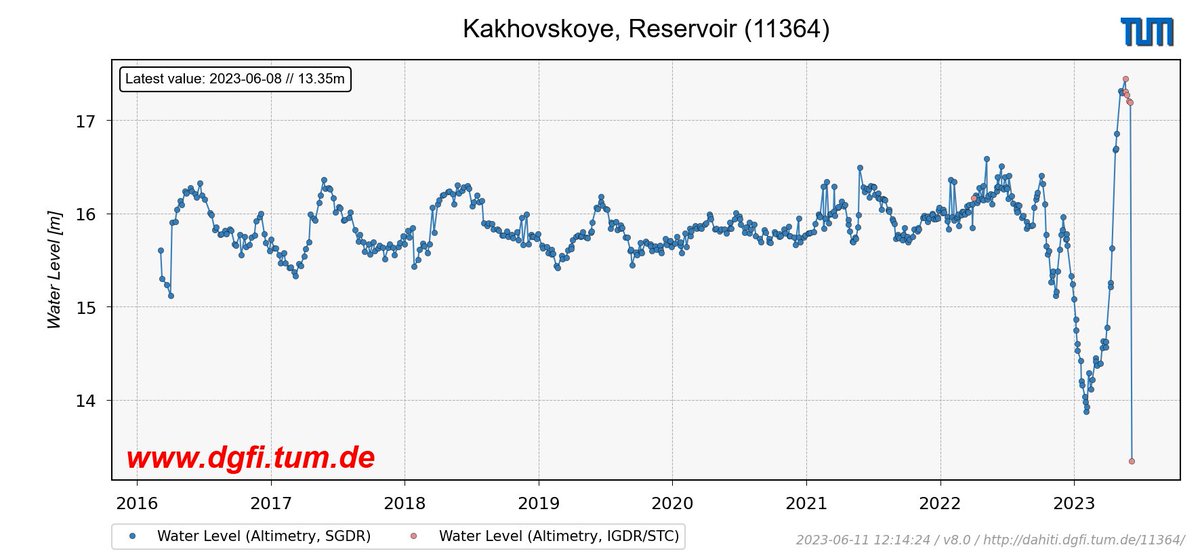
#Sentinel3 satellite #altimetry data show the result of #Kakhovka dam destruction: between June 6 and 8, the water level dropped by >4 meters. Current satellite-based water levels of reservoir & #Dnieper are freely available in @DgfiTum's DAHITI database (https://t.co/ntRFFQRtIX)
With IRIS (#ICESat2 River Surface Slope) we provide global water surface slopes at reach-scale referenced to SWORD (#SWOT River Database). IRIS can be used to calculate ECV #RiverDischarge. Details: Nature Scientific Data, https://t.co/xf5g2vopBG. Access: https://t.co/IGELsQYgco
Fully focused SAR processing of #Sentinel6#altimetry data was shown to improve the accuracy of coastal Significant Wave Height (SWH) estimates in the #NorthSea. From the measurements, a 26.4% decay in SWH can be inferred between 30 km and 1 km offshore: https://t.co/Fcpc8yEAtc
Data-driven interpolation of sparse along-track #altimetry data with Random Forest Regression leads to improved characterization of #SeaLevel variability. This is shown by a case study for the #NorthSea in comparison to conventional optimal interpolation: https://t.co/cHz0akBbd8
Thin sea ice plays an important role in sea ice production, ventilation & heat exchange between polar ocean and atmosphere. A study highlights how #CryoSat2 SAR #altimetry can reliably monitor thin ice and open water at high spatial & temporal resolution: https://t.co/Kk8u9F3NU8
Systematic errors in #SeaLevel trends can occur if measurements of #altimetry satellites are not properly corrected for the plasmaspheric electron content. A new study shows how simply scaled GNSS-based #ionosphere maps can significantly reduce this error: https://t.co/mHSVe1pbzq
A milestone is reached! For meanwhile 10,000 targets worldwide our DAHITI Database for Hydrological Time Series of Inland Waters provides free hydrological information like water level, surface area & volume change from satellite data. Explore it at https://t.co/SirbRVBRYD
#Lakes
River slopes observed by #ICESat2: New algorithm enables the use of lidar data for continuous monitoring of water surface slopes (WSS) on reach-scale. WSS is essential for estimating flow velocity & discharge, and relevant as an altimetry range correction: https://t.co/gunSZOGG1T
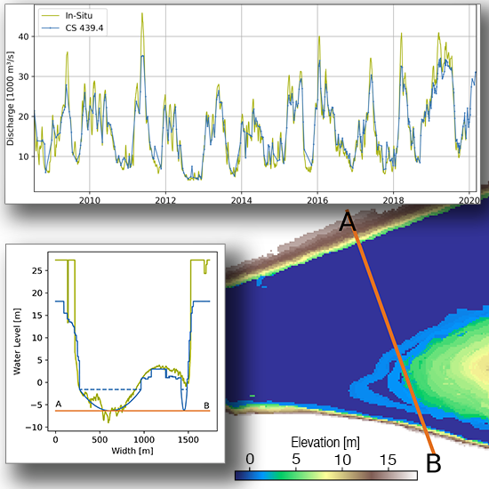
In a study related to GlobalCDA, project members from DGFI-TUM recently estimated Long-Term Discharge for the Lower Mississippi River Using Satellite Altimetry and Remote Sensing Images. Read more on https://t.co/5s73IHiYBp
Project members from DGFI-TUM recently published a paper related to the GlobalCDA project estimating
Volume Variations of Small Inland Water Bodies from a Combination of Satellite Altimetry and Optical Imagery.
Take a look at https://t.co/Ces9adHvr3
American fury at news of a German submarine firing torpedo on US Navy ship Greer in mid-Atlantic. USA's debate over joining the war is heating up. Cartoonist Dr. Seuss's view: