Yesterday, there was discussion in some quarters that the extraordinary rainfall over #Lonavala was a "once-in-a-thousand-year" event !
While #Nature, however, had other plans. 🌧️😄
Within just 24 hours, the #Sahyadri once again produced another 600 mm-plus deluge, reminding us that the atmosphere doesn't always follow our expectations.
As a result, #Lonavala has recorded an astonishing 1,290 mm of rainfall in just 48 hours, making this one of the most remarkable back-to-back rainfall episodes in recent memory.
🌧️ 6 July: 670 mm
🌧️ 7 July: 620 mm
This extraordinary spell once again highlights the immense rainfall potential of the #Bor #Ghat–Sahyadri region when a strong #monsoon surge, deep moisture transport, with wind converging and persistent orographic lifting align simultaneously.
Nature has its own way of reminding us that every extreme event deserves continuous observation—and that the atmosphere can still surprise us.
#WeatherAnalysis #WeatherUpdate #SWM2026 #Monsoon2026 #July2026 #deluge #MumbaiRains #PuneRains #KonkanWeather
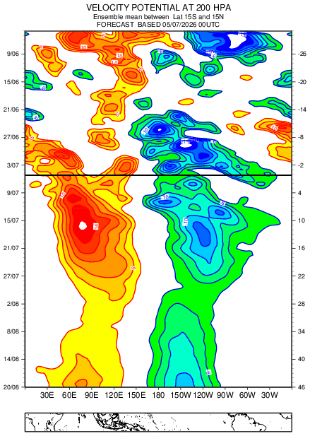
Look at the enormity of #Elnino suppression that is likely to dominate Arabian sea adj Indian landmass in the coming weeks.. Monsoon flow very likely to get disrupted & so anomalous dryness/harsh sunny weather may take control..
dc @TropicalTidbits
#Monsoon2026 #India #Elnino #Drought # #MJO #Elninoupdate #Mumbairains #Mumbai #Konkan #Weatherupdate #Monsoonupdate #Arabiansea #Saudiarabia #UAE #Yeman #Oman
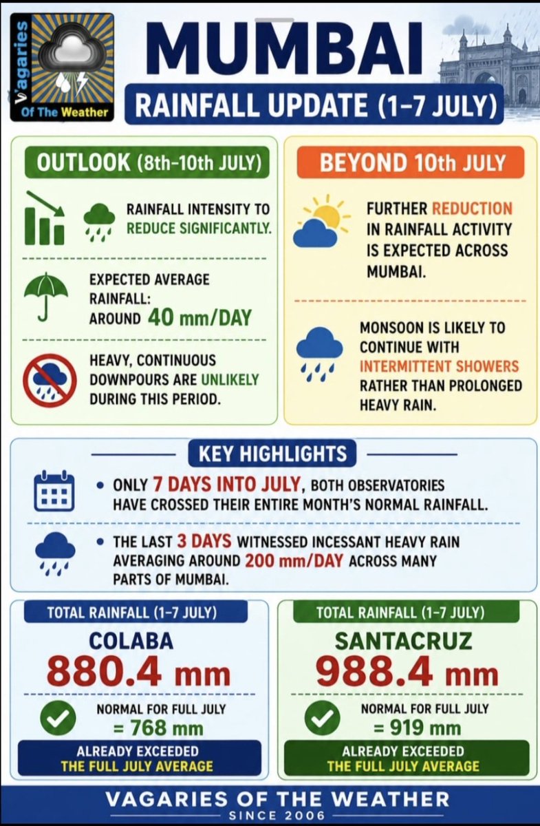
Santacruz Rainfall.SWM 2026. Data IMD
1 July : 96.3
2 July : 204.6
3 July : 101
4 July : 109.6
5 July : 227.7
6 July : 159.2
Total 898.4 mm in 6 days. 5 tons on the trot. 6th loading tonight. This is some consistency. @meet_abhijit@Selwyyyyn@Gokul46978057@santha75@ramkrisv
Rainiest month across major global metropolitan cities.
There is simply no competitor to Mumbai. It receives twice the rainfall as it's nearest competitor.
And this year, it received it's monthly quota in 5 days. Insane stuff.
The monsoon system is firing on all cylinders now in terms of secondary vortices on the Arabian Sea side and an LPS from the Bay of Bengal. This combination brings large-scale extreme rain events that can last for a while. Horizontal shear and energy are also available for MISOs now. Will this sustain itself or does Mother Nature have other plans? Rossby waves from El Niño can still tinker with the monsoon. It’s not much fun to be a farmer! Let’s be grateful to them for trying so hard despite all these risks and uncertainties. #monsoon #elnino #extremerain #drought #flood #agricultuee
#Historic#rainfall battered the #BorGhat region spanning the #Raigad–#Pune districts, producing an extraordinary event across the #SahyadriGhat 🌧️⛰️
In my experience, I have never come across a 24-hour rainfall total exceeding 600 mm at #Lonavala, making today's event truly exceptional.
The region recorded astonishing rainfall totals over the past 24 hours ending 8 am of 6-7-2026:
🌧️ #Lonavala – 670 mm
🌧️ #Khandala – 576 mm
🌧️ #Khopoli – 516 mm
Such exceptionally intense rainfall triggered multiple #landslides, leading to disruptions and closures along the #Bor #Ghat rail corridor as well as affecting the newly constructed Missing Link expressway section.
This historic spell serves as a reminder of the immense power of nature, as the newly developed infrastructure was put to its first major real-world test under one of the most intense rainfall events witnessed in the region in recent years.
#KonkanWeather #Maharashtra #MumbaiRains #PuneRains #July2026 #deluge
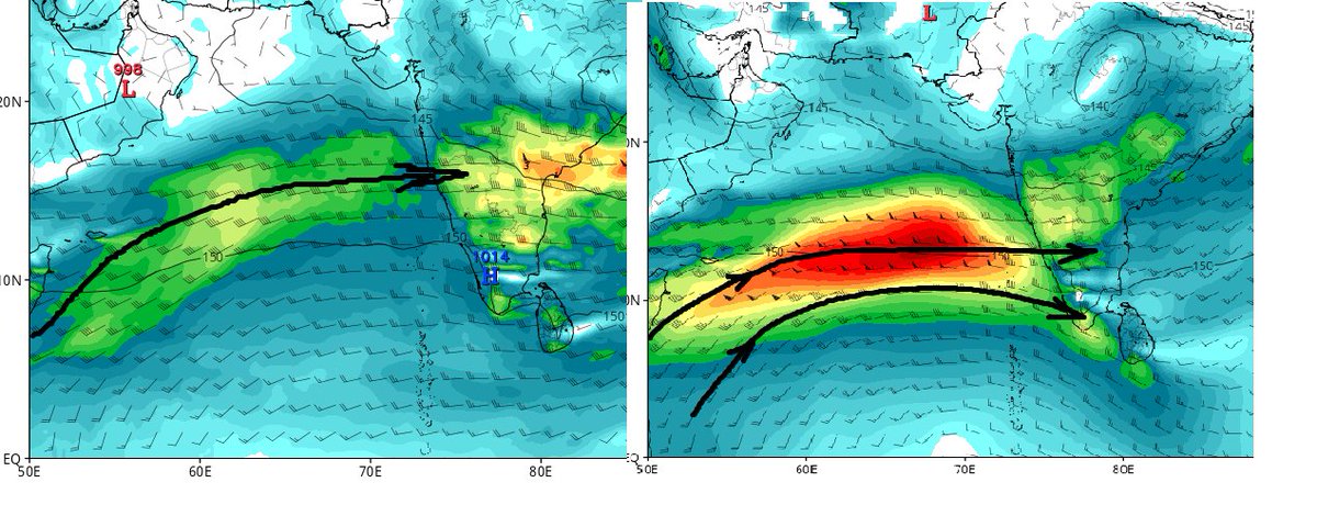
After causing rampage over #Konkan & adj Ghat section ,Monsoon Low level jet (LLJ) axis seen descending down in latitude & this kinda flow may offer downstream convergence & need to see how far this could help those states.... Coastal #Karnataka adj ghat ,adj North kerala Ghat section in the coming days.. Due to strong westerly surge , TN coast struggling to see sea breeze & so not much activities seen.
Conditions might turn worse over lower latitudes in the coming days with #elnino suppression keeps looming!! Hot weather may make it worse but with ideal moisture content , the same hot temperature might help to break the inversion in some pockets leading to TS initiation ...
dc @TropicalTidbits
#Monsoon2026 #Madhyapradesh #Chhattisgarh #MumbaiRains #GoaRains #Konkan #Delhi #Westbengal #Elnino #Kerala #Keralam #Monsoon2026 #Rainalert #Rainupdate #Weatherupdate #TamilNadu #TNRains #Karnatakarains #Keralarains #Arabiansea #Bayofbengal #MJO #Indianocean
No other city in the world would be able to function after receiving the kind of rainfall Mumbai has recieved over the last few days. The fact that offices are open, stock market running, airport operating and people still making it to meetings etc is a true testament to the incredible spirit of our great city. Salute to Mumbai and to all those who love and live in our great city.
6 Jul,IMD model guidance for 6 & 7th indicate;Very likly of hvy to very hvy🟠rainfall at few places, extremely hvy🔴spells at isol places & strong gusty winds in parts of N Konkan (incl Mumbai), parts of N Madhya Mah(incl ghat areas) as depression moves further inward.
Watch IMD
Alarming bell as #Elnino to tighten its grip over Indian Basin.
North & South Peninsular Indian states may see soaring record high temperature in the coming weeks as #Elnino suppression to strengthen manifold causing below normal rains, clear weather conditions which ll help temperature to set a record high... We needs to be prepared well to face this
DC @ECMWF
#TamilNadu #Kerala #Andhrapradesh #Bengaluru #Karnatakarains #TNRains #Monsoon2026 #Elnino #MJO
As anticipated, a mesoscale #vortex developed along the East–West monsoon #ShearZone near the #Palghar–#Manor region, significantly enhancing the local monsoon dynamics. 🌧️
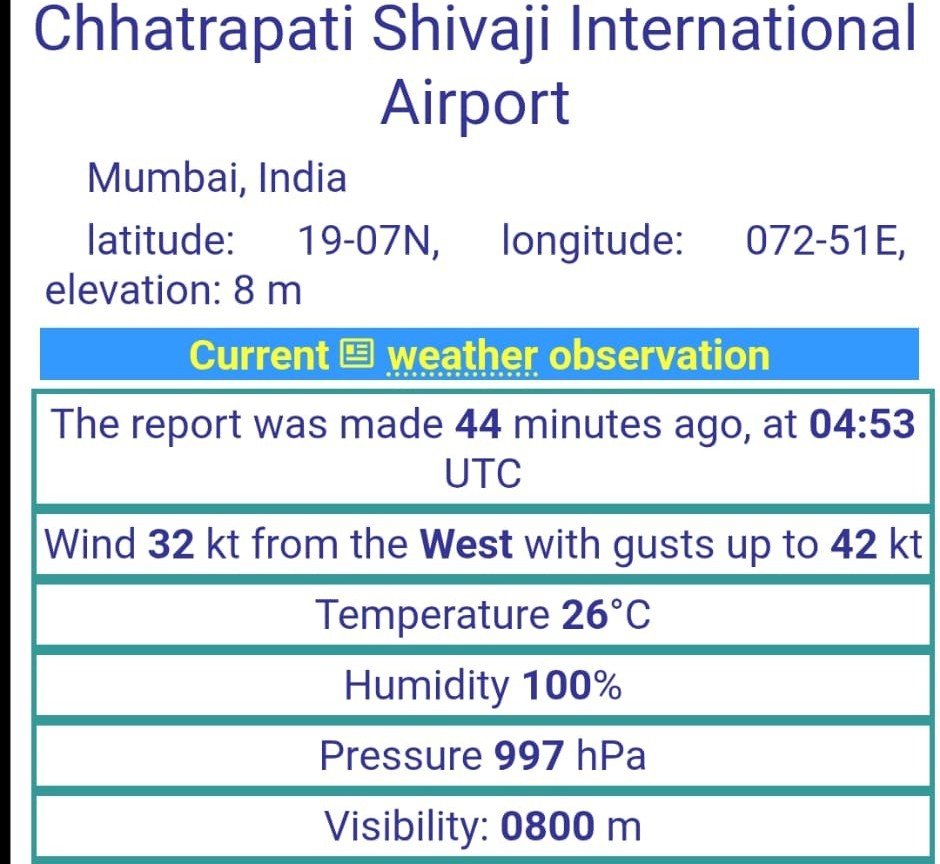
The strengthening of this vortex resulted in a sharp pressure fall over the #Mumbai region, with mean sea-level pressure dropping to around 997 hPa. Simultaneously, strong convective winds accompanied the system, with wind gusts of up to 80 km/h reported at #CSMIA, according to #METAR observations around **10:30 AM.
From a #rainfall perspective, precipitation associated with such vortices is always challenging to forecast because the heaviest rainfall often becomes highly localized and depends on the exact position and movement of the circulation.
Nevertheless, as indicated in the earlier outlook, there was potential for 300 mm-plus rainfall where the vortex became anchored, and that scenario has now materialized.
The most intense rainfall overnight was concentrated over the southern quadrant of Mumbai, parts of North #Raigad district, particularly #Panvel, #Khalapur, #Matheran, #Karjat, and the adjoining #Sahyadri Ghat sections, including #Khandala to #Tamhini, where extremely heavy rainfall was recorded.
Following the passage of the most intense phase, rainfall has reduced to intermittent drizzle across many areas, accompanied by breezy conditions as the vortex gradually weakens.
Looking ahead, #atmospheric conditions remain favourable for heavy rainfall until 7 July, with Raigad district and Mumbai currently appearing best placed for further significant rainfall.
Thereafter, rainfall prospects over #Thane and Palghar districts will depend largely on the future movement and positioning of the monsoon shear zone. If the primary vortex-induced event has already peaked, these regions are likely to continue receiving generally heavy rainfall upto 250 mm may be if any, although the probability of another widespread 300 mm-plus event may reduce unless a fresh mesoscale circulation develops.
#WeatherAnalysis #WeatherUpdate #KonkanWeather #Maharashtra #July #SWM2026 #Monsoon2026 #MumbaiRains
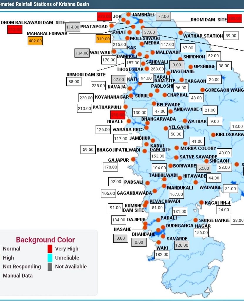
With a stunning 408 mm rainfall, #Matheran has seen it's 2nd Highest 24 hr July rainfall on Record, beating previous placeholder from 1976 😲
The ATR however, stands at an astounding 843 mm from the historic 26 July 2005 spell!
#Monsoon2026
Pc Google
Unprecedented extreme rains in #Mumbai belt.. Khargar 386 mm, Vikhroli 303 mm, Powai 278 mm, Mumbai Colaba 266 mm, Andheri 243 mm, Santa Cruz 227 mm!!
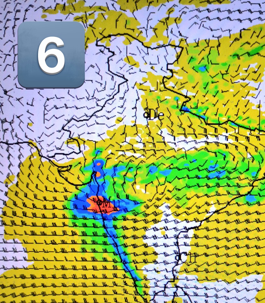
More heavy rains are expected to happen as strong vortex has developed close to #Mumbai coast along the E-W shear zone with another WML spinning over #Odisha coast in BOB. This setup is just brutal for extreme rainfall event.
Stay safe Mumbai & surrounding people as things don’t look good at all.
#Mumbairains #Mumbai #Monsoon2026 #SWM2026 #Mumbaifloods
@Selwyyyyn Very true . Can't agree more Just felt that year on year the required numbers are met whether it's an early onset/ progression over Konkan or delayed or the nature/ pattern of precipitation .
@Selwyyyyn Having spent close to 20 years in Mumbai & Navi Mumbai ,experienced SWM over there , I somehow feel every single time Mumbai Konkan region rains are beyond all these ENSO / IOD conditions and the like.Somehow every single year they find a way to get its annual quota without fail