I am excited & very glad to share this proud moment.. Yes, you have made it.. Congratulations @Gokul46978057 presenting your analysis on #Monsoon2026 in the discussion session in front of various experts.
It is not an overnight dream & I know behind this achievement, you would have come across lot of pain, sacrifices,embarrassments demotivations & still you didn't giveup on ur journey , making all the hurdles into a challenging task & kept shining bright. 🤩🙌🏽
It's been a remarkable journey to say the least
From TCS KT session to IITM weekly/ monthy monsoon performance discussion session, from watching different monsoon presentation videos in YouTube to presenting your own analysis on the stage is purely an unbelievable stuff..
Wish to thank everyone who supported you in this wonderful journey ... Congrats again & wish u all the very best for your future 🙌🏽🤩
#Monsoon2026 @iitmpune@ChennaiRMC
Big update on #Monsoon2026 rainfall under #ElNiño suppression umbrella
Monsoon conditions established over SE Arb sea adj #Kerala during the last 24hrs with steady rains& stiff winds. It should have progressed earlier considering the early arrival over eq waters adj #SriLanka but various negative factors collectively made the monsoon advancement to slow down.
Anyhow, now this onset is far better considering prev elnino years which caused delayed onset & poor progression. Now this onset surge is expected to cover #Karnataka & progress till #Goa #Konkan during the next 4-5 days. Maybe therafter there could be a break.. Lets see
In this 2026 SWM season, there is a major concern on monsoon rainfall over the country due to developing strong elnino event in the pacific ocean. Most models/agencies expecting seasonal rainfall to be lesser than normal rainfall across the country. So this year could be an anomalous year for various reasons.. Everyone get familiar with thesewords "anomalous" & "anomaly". We may need to use this word frequently during the next 12-15 months.
Elnino is an anomalous event that results in changes in atmosphere & ocean. Basically it is against mean state/normal conditions. Example :Cooler waters turns warmer & warmer waters turns relatively cooler This is primarily due to elnino phenomenon which would bring anomalous changes in the ocean & finally it influence the global atmosphere through teleconennections.
Now what is "anomalous changes" ? anything that deviates from normal value.
So a wet monsoon region may turn drier /receives lesser rainfall & dry region may get wetter. so after 2009/2015 elnino event, we are about to see a major elnino influence on monsoon rains. Central West-NW,South india witness a negative impact during elnino. These regions tends to receive lesser rainfall but during 2023 prev elnino year, interestingly it wasn't that bad. It got modified by mid lat systems intrusion . interactions made the atmopshere so complex &so seasonal rainfall was high with lot of extreme events over NW India.
Now what to expect in this monsoon? Basically elnino suppression affects monsoon rains through various ways.
1.Prolonged break phase & lesser days of active phase 2. Shift in monsoon Low genesis area & shift in track with lesser inland penetration.
3. More mid lat systems intrusion
4. Increase in strength of convective storms regionally so high risk of lightning/thunders.
States/regions that holds moderate probability for normal- slightly above normal monsoon rainfall
1.Kerala & adj parts of coastal Karnataka (enhanced cross eq flow in bay favors these states)
2.WB adj Odisha/Jharkhand/ Bihar (considering the shift in monsoon Low genesis area to North-Northeast Bay of Bengal )
3. Parts of East coast stretching from North AP coast to N TN coast. This stretch may see enhanced thunderstorm activity during break phase/ inactive phase of monsoon (anomalous NW winds collide with evening sea breeze to trigger thunderstorm activities)
Western /NW India,Core region covering central India into northern plains is the major area of concern where majority of the rains are driven by monsoon lows/ active phase of monsoon. If it is affected by elnino induced changes, there could be a serious concern.Wish some other factors override this elnino impact on monsoon & so less impact hopefully..
Another thing to highlight about an elnino year is the possibility of extended harsh summer conditions/ Heat wave .Generally Northern hemisphere summer attains a peak during July/Aug but only in india adj countires we see different theme just bcos of monsoon season coinciding with summer. Active rainy weather /enhanced cloudy conditions makes the summer totally different in India.
Now what happens when elnino suppression leads to lesser clouds/lesser monsoon rainfall activity over India? we get exposed to harsh summer weather. So need to be prepared for this as well
Charts dc @IMDWeather@eumetsat
Are we seeing the onset picture by 3rd June?
East-west shear zone at mid troposphere continues to linger around South #kerala lat .. It is not progressing North to favor monsoon onset scenes over #kerala..
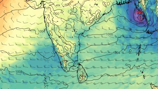
Now promising signs seen in the latest forecast from @ECMWF with a development of strong disturbance over EC Bay adj NE Bay around May end/early June . This would align westerlies over SE Arb sea adj west coast ,leading to enhanced rainfall over #kerala #Karnataka during the subsequent days...
#Elnino #Kerala #Keralam #Monsoon2026 #Rainalert #Rainupdate #Weatherupdate #TamilNadu #Karnataka #Thunderstorms #Onset #Onsetupdate #Karnatakarains #Keralarains #Arabiansea #Bayofbengal #MJO #Indianocean #Monsoonjet #Monsoononset #ChennaiRains #Summer #Heatwave
Enhanced cloud cover /rains over #Kerala latitude confirms ITCZ passing nearby.. Some station even reported heavy-very rainfall during the last 48hrs with the help of same large scale setup through East-west Trough.. Disturbance moving westward seen as a hindrance however monsoon flow almost at a striking distance .. Rains might be enhanced during the next 3-4 days creating onset conditions over SE Arb sea adj Southern kerala
charts dc @IMDWeather@Indiametdept@eumetsat
#Elnino #Kerala #Keralam #Monsoon2026 #Rainalert #Rainupdate #Weatherupdate #TamilNadu #Karnataka #Thunderstorms #Onset #Onsetupdate #Karnatakarains #Keralarains #Arabiansea #Bayofbengal #MJO #Indianocean #Monsoonjet #Monsoononset #ChennaiRains #Summer #Heatwave
Kerala Monsoon onset -Update
Recent @ECMWF update shows monsoon LLJ axis gaining latitude & reaching south kerala lat around 23/24th May. Also mid tropospheric East-west shear zone appearing over 10-11N latitude at the same time & this large scale setup seen extending all the way from SW Arb sea off Somalia coast till SE Arb sea adj Kerala . I feel onset could be declared during this window of opportunity assuming all necessary criteria (increase in rainfall over kerala coastal stations,Onset vortex(not a must case), E-W shear zone over Kerala lat ,enhanced rains/cloudiness over SE Arb sea adj waters) would be met.
Thereafter there could be some temporary hiatus as
We could see two disturbances developing inside the mid tropospheric E-W shear zone & one turning intense as it drift westward during the subsequent days. These westward moving disturbances at this point of time could disturb the monsoon flow by restricting it from reaching the west coast & also causing local subsidence over west coast leading to lesser rain activity..
Let's see how scenes unfold
dc @TropicalTidbits@Weathernerds@ECMWF
#Elnino #Kerala #Keralam #Monsoon2026 #Rainalert #Rainupdate #Weatherupdate #TamilNadu #Karnataka #Thunderstorms #Onset #Onsetupdate #Karnatakarains #Keralarains #Arabiansea #Bayofbengal #MJO #Indianocean #Monsoonjet
We may see monsoon onset like conditions emerging in the next 4-5 days with mid tropospheric shear zone along kerala latitude,enhanced rains/cloudiness over Lakshadweep adj SE Arb sea during the next 4- 5 days .
This large scale setup is due to eq wave activity where we could see a westward moving disturbance marching towards Arb sea from Bay ...
This bogus onset like conditions seen favoring #Keralam #Karnataka during the next 4-5 days so there is a possibility of heavy- very heavy rains over parts of coastal kerala,karnataka in the coming days . Bulk of rains/clouds would prefers to stay offshore but still those clouds might affect isolated coastal pockets leading to very heavy rains/ intense thunderstorms over coastal /Ghats..
Charts @TropicalTidbits
#Elnino #Kerala #Keralam
#Monsoon2026 #Rainalert #Rainupdate #Weatherupdate #TamilNadu #Karnataka #Thunderstorms #Onset
South Asia including India to experience widespread below normal summer monsoon rainfall in the coming months ( Jun - Sep '26) as per latest forecasts:
-----------------------------------------
The latest available long/seasonal range forecasts issued in May 2026 from various global climate modeling centres continue to indicate a generally drier upcoming monsoon season that could be widespread in spatial distribution too. Global forecast charts indicate that this reduced rainfall forecast could be directly associated with developing El Nino conditions over the equatorial Pacific Ocean as a first order approximation. Climate indicators like the relative Nino 3.4 index have been pretty consistent with tendencies comparable to a warm ENSO event that is anticipated to establish in the following months. The latest weekly value was observed to be above +0.5°C, the highest seen after late spring months in 2024. While the other climate indicator, the Dipole Mode Index associated with the Indian Ocean Dipole is seen fluctuating within the neutral state as of now.
Images sourced from @WMO composite maps of seasonal forecasts issued in May 2026. Analysis and interpretations here are mine alone in an attempt to understand various processes of the Tropical weather and climate. For official forecasts please follow the respective official weather and climate forecasting agencies.
Plenty of action in the form of rains/thunderstorms likely over E-NE part of India as strong low level moist southerlies from Bay of Bengal & dry continental flow from west-NW causing confluence/convergence zone .
This zone is also known for severe orographic rainfall events due to moisture incursion from bay of bengal in the month of April/May.
Moving down south, anomalous mid lat westerly system leading to increased instability in the atmosphere. So this is very likely to increase the line of wind discontinuity associated seasonal convective rains over interior parts of TN, kar & kerala during the coming week..
Extended stay of bay anticyclone would push easterlies into peninsular India which might keep parts of TN away from dry westerlies reach for some days..
This anomalous moist flow from Bay would even favor enhanced convective rains over southern India including TN,Kerala..
There is also chance of disturbance formation over lower latitudes closer to southern peninsular India on either sides of landmass.. Not much clarity seen yet & it depends how the cross eq flow surge build up & moves eastward to gain significance.
Let's wait & see.
dc @NOAA@NWSCPC@TropicalTidbits
#ElNino #Monsoon2026 #India #SWM2026 #TamilNadu #Kerala #Karnataka
#Thunderstorms #Rainupdate #TNRains #Summer #Heatwave #Assam #AndhraPradesh #Meghalaya #Mawsynram #Bangladesh #Westbengal #Sikkim
More often tropical disturbances forms within the ITCZ so once if planetary scale convergence zone shifts to its counter hemisphere ,there would be a common opinion ,even some of the twitter handles/pages rules out saying TC/TD doesn't form in the basin during JFM but no ,its not right always.. ITCZ contributes to major count of TC's in the Bay of bengal but in some cases, disturbances do shape up through tropical waves, even remnant energy from Borneo vortexes or any pre existing energies..
In these cases system in the opposite hemisphere helps to spin initially through eq westerlies when they spin near the eq waters. Once they gain latitude, they get enough Coriolis force to spin effectively..
Generally speaking even a cluster of thunderstorms could turn into a tropical cyclone if conditions keeps supporting .. Disturbances tends to form when essential conditions are met in the ocean & atmosphere.. Yes,This is one of the classical real-time case where we could see tropical disturbance development in the bay despite ITCZ in Southern hemisphere.
Ideal SST which supplies warm air that acts as fuel , good convergence at lower level , Good divergence at upper level ,low-mod shear boosts TC genesis.
we have seen many cases in JFM especially during /after a Lanina, Negative IOD events.
sat image @Windycom@eumetsat
#Rainupdate #TamilNadu #TNRains #Puducherry #Januaryrains #Easterlies #Chennai #ChennaiRains #SriLanka #Kerala #LaNina #Bayofbengal #MJO #Indianocean #Tropicalupdate
Here is the comparison of Mid tropospheric flow..
We could see mid lat westerly trough to the North & two anticycloninc flow bringing moist winds & dry winds from two different sides converging over North coastal TN..
Atmospheric setup could be same but other factors like moisture level, intensity of convergence varies so obviously rainfall amount varies..
chart dc @JMA
#Chennai #ChennaiRains #HeavyRains #DitwahCyclone #CycloneDitwah #Thunderstorm #Rainupdate #TamilNadu #RainAlert #Tiruvallur #Kanchipuram #AndhraPradesh
GFS seen giving significance to NER (Near Eq ridge) which restricted westward movement, North Bay anticyclone associated ridge didnt extend like what ECM projects. Importantly It allowed this disturbance to detach from parent ER wave but ecm keeping it inside so moving Northwest
Of late many are into discussion why there is literally no winds.
Technically speaking we are now falling inside a "col region"where winds wud be nil/calmdiverge
Two low pressure areas on either sides of the southern India & pressure here will be relatively higher when compared
NEM is generally a wind reversal followed by rains
We cant expect rains to pour simultaneously when winds set-in tat too with no disturbance
First wind establish & then rains happen
Gummidipoondi 17cm
Ponneri-13cm
Parts of Chennai have got fairly 8-10cm in the last 48hrs
@ECMWF ens remains rigid with steady NW track into NTN/SAP. Meanwhile 2 important things to highlight here is that the models delaying the main event significantly to 27/28th but still 23/24th oct would be still under watch for heavy rains through fresh disturbance/E-W trough
Suppressed phase of an eq wave to cause a brief disruption to the negative IOD standing wave & once it eases away ,we may again see a full blown effect of -IOD in the coming weeks..
hence W-NW moving anomalous rain wave/disturbances would extend the monsoon.
dc @ECMWF#Monsoon