📣 Introducing Lead Moderators: a new role that helps streamers manage their growing communities!
Lead Mods can add/remove other mods and update all channel moderation settings (including those previously only available to streamers) 🛡️
🔗 https://t.co/LWGk4p8wka
10pm EST Key Messages on Potential Tropical Cyclone #Eighteen: No big changes from the previous advisory- forecast to strengthen to a hurricane in the NW Caribbean by early Wed
More info: https://t.co/tW4KeGe9uJ
5 am EDT - Hurricane #Milton moving off the coast of east-central Florida. Still producing damaging hurricane-force winds and heavy rains. Here are the Key Messages. Go to https://t.co/tW4KeGe9uJ for details.
Hurricane #Milton Advisory 21: Milton Moving Off the Florida East Coast. Still Producing Damaging Hurricane-Force Winds and Heavy Rainfall in East-Central Florida. https://t.co/tW4KeGe9uJ
10pm EDT #Hurricane#Milton Position Update:
A Flash Flood Emergency is in effect for the Tampa Bay Area as Milton continues to move inland.
A sustained wind of 86 mph & gust of 105 mph was recently reported at a WeatherFlow station at Egmont
Channel.
https://t.co/v4gAigvVS9
5pm EDT Oct 9th Key Messages for #Hurricane#Milton:
Many hazards ongoing in association with the hurricane currently, with life-threatening storm surge & hurricane-force winds expected on west FL Peninsula tonight.
https://t.co/LQEVorqXZH
10 pm - Category 5 Hurricane #Milton near the northern Yucatan Peninsula. The hurricane poses an extremely serious risk to Florida. Here are the Key Messages. Visit https://t.co/tW4KeGe9uJ for details.
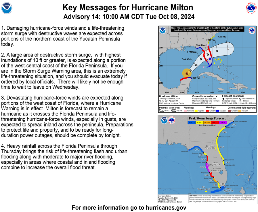
10pm CDT Oct 6th Key Messages for #Hurricane#Milton:
Forecast to become a major hurricane on Monday. Hurricane and Storm Surge watches likely to go up early Monday for portions of W coast Florida Peninsula.
Latest: https://t.co/LQEVorqXZH
Here are the Key Messages for Sunday late morning for Tropical Storm #Milton - people are encouraged to follow along for the latest updates at https://t.co/tW4KeGe9uJ
4PM CDT Oct 5: Tropical Storm Milton is forecast to strengthen quickly and bring the risk of life-threatening impacts to portions of the west coast of Florida Tuesday or Wednesday. Make sure to check back for updates through the weekend and into next week at https://t.co/Wq6ZtKgfeH
10AM CDT Oct 5: Tropical Depression Fourteen forms in the southwestern Gulf of Mexico. Forecast to strengthen and bring the risk of Life-Threatening impacts to portions of the west coast of Florida next week. Make sure to check back with updates through the weekend and into next week at https://t.co/Wq6ZtKgfeH
12am EDT Friday Tropical Cyclone Update on #Hurricane#Helene:
The eyewall continues to move inland over the #Florida Big Bend & Panhandle. Please do not leave your shelters and remain in place through the pass of these life-threatening conditions.
https://t.co/XtkxtGDQLT
As #Helene continues to approach the coast, please do not get overly focused on short-term wobbles in its track, "false" eye locations, or on specific computer model simulations.
EVERYONE along the Florida Big Bend coast is at risk of potentially catastrophic storm surge and damaging hurricane-force winds later this evening, and life-threatening storm surge is already increasing along the west coast of Florida.
Continue to follow https://t.co/Wq6ZtKgfeH and https://t.co/AG05fN6p0n for the latest forecast.
Here are the 4am CDT 25th September Key Messages for Tropical Storm #Helene.
Forecast to rapidly intensify to a Major Hurricane & grow in size in E Gulf of Mexico. Danger of life-threatening storm surge along entire W Florida coast & Big Bend area.
https://t.co/XtkxtGEoBr