@ajktwt@JungIndien True, and the label sticks to places that don't fit it at all. Drive from Thrissur to Kozhikode and the shops and houses barely break for a field, yet for years much of that stretch was counted as villages.
Agreed, Jodhka's point still stands. We couldn't find a stated reason in the 1971 Census. Our best guess: 1971 also changed who counted as a worker and the count of working women fell sharply, so men looked like the steadier measure.
Today the rule errs both ways. It hides Murshidabad's bidi workers and inflates Hamirpur's non-farm share. MoHUA flagged the same "male bias" in 2024.
Rural India is lighting up.
What hasn't moved is dehat as a label: a census rule first written in 1961 that still counts lit, built-up places as villages, and leaves them governed as villages.
Read our full argument on @JungIndien. Thank you @sirfaditya and @kavitaayeinn
Census 2011 says 31% of India is Urban, while World Bank and UN estimate it to be 55% and 63% respectively. So, why does India underestimate its urban population?
@SpatialIndia argues that the fault lies with the Census’s two-box urban/rural classification criteria and calls for a third category for areas in transition.
https://t.co/bIIjFlLW29
On paper, eastern UP and Bihar are mostly villages. From orbit, their bright night light more than doubled between 2012 and 2024.
Our essay in collaboration with @JungIndien argues India needs a third category for places that are neither village nor town.
Census 2011 says 31% of India is Urban, while World Bank and UN estimate it to be 55% and 63% respectively. So, why does India underestimate its urban population?
@SpatialIndia argues that the fault lies with the Census’s two-box urban/rural classification criteria and calls for a third category for areas in transition.
https://t.co/bIIjFlLW29
In Swades (2004), an engineer from NASA brings electricity to his village.
Some 20 years ago, electricity reaching a village was the sort of achievement that deserved to be celebrated in cinemas.
Launched in 2017, Saubhagya scheme would electrify 2.86 crore households by 2022, including Leisang in Manipur which is counted as the last inhabited census village.
In this satellite image created by @SpatialIndia you can see the growth of bright lights in the farming districts of Eastern UP and Bihar between 2012 to 2024.
Rural India is urbanising rapidly modernising but is the Indian Census equipped to see it?
@JungIndien’s latest essay in collaboration with @SpatialIndia examines the rules behind Census classification, and why India needs a third category for places between villages and towns.
Read here: https://t.co/bxkNNzJHAx
Every Indian dataset is drawn on a different India.
Telangana had 10 in the 2011 census. The last big health survey counted 31. Today it's 33. Every dataset you download picked a different year's map.
Put them all on one map and things start to show up. Like 86 districts where 4 in 10 kids were stunted, and banks lend less per person than in three out of four districts.
We do the slow part. 100+ indicators on one district map, ready to compare with each other or with your own data: https://t.co/1dWdFjWHXh
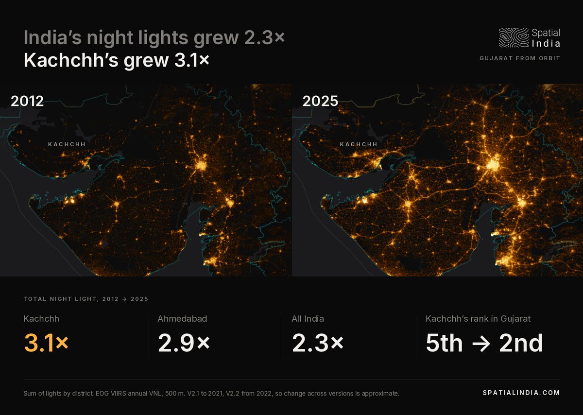
India's night lights grew 2.3× from 2012 to 2025, but Kutch's grew 3.1× and it went from Gujarat's 5th brightest district to 2nd. What do you think lit it up?
Explore 13 years of satellite night lights for every district on Spatial India.
Kota and Jhalawar share a border. In Kota, 76.5% of women can read. In Jhalawar, it is 54.3%.
Rajasthan ranks 34th of 36 states on women's literacy, but the state average hides a 22-point gap across one district line.
How does your district compare? https://t.co/pUjNcZaXN9
The gas sits off the Mahanadi delta. In the delta districts, about 7 in 10 homes still cooked without clean fuel: Bhadrak 23% on clean fuel, Kendrapara 28%, Jagatsinghpur 31%.
Odisha overall is 35%, 4th lowest state. Local supply and city gas could move these numbers fast.
Mapped on @SpatialIndia using NFHS-5.
Nuh and Gurugram share a border.
Women with 10+ years of schooling: 14% in Nuh, 60% in Gurugram. (NFHS-5, 2019-21)
Is there a district border near you where the numbers change this sharply?
Explore your district data on @SpatialIndia
In Bihar, half of all pending cases in district courts are more than 5 years old.
In Punjab, it is about 1 in 20.
Same court system. The age of the backlog depends on the state.
District court data, NJDG, July 2024. Mapped on @SpatialIndia
India just had its best-ever July–September quarter for exports.
Across India, 1 in 4 registered MSMEs is a manufacturer. In Tiruppur and Surat it is nearly 1 in 2.
Surat alone has 2.7 lakh manufacturing MSMEs, the most of any district and nearly as many as all of Kerala.
Explore the live map on @SpatialIndia
Lakshadweep was declared fully literate this week. In 2019-21, NFHS-5 already found 96.5% of its women aged 15-49 literate.
In 744 of 777 districts, most women could read.
Where's the next milestone? The light patches: western MP and southern Odisha.
@IndianTechGuide Good call by the court. Counter tickets are what many poorer passengers buy, and often they have no other cover. Households with any health insurance (NFHS-5, 2019-21):
Rajasthan 88%
UP 16%
Bihar 14%
Same train, very different safety net.
@pubity The growth is broad. Bank credit rose 14% in FY26 and shrank in only 6 of 776 districts, per @RBI data. Tamil Nadu led at 19%, Bihar and Assam trailed at 11%. Does the IMF projection assume the east catches up?
Data from @SpatialIndia