The Storm Prediction Center has OFFICIALLY rolled out its first graphics update since the Enhanced risk was introduced in 2014.
Changes:
- Graphics update, cleaner and looks better
- Introduced Conditional Intensity hatching levels (CIG 1-3)
- Added additional wind levels (75%, 90%)
- Additional changes to both the NWS & SPC website
Curious to see how this works out!
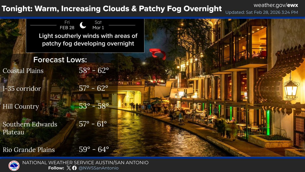
Tonight: Expect another very warm night with increasing clouds and patchy fog developing overnight. Many areas will remain in the upper 50s to low 60s. #txwx
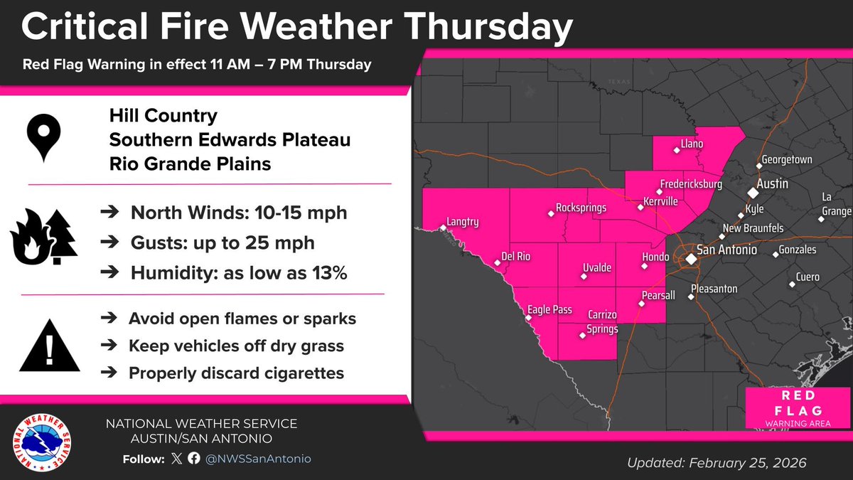
A Red Flag Warning issued for the Hill Country, Southern Edwards Plateau and Rio Grande Plains (11 AM to 7 PM) Thursday. Breezy northerly winds of 10 to 15 mph with gusts up to 25 mph and humidity values as low as 13% will produce critical fire conditions across the area. #txwx
Morning satellite loop of the very strong Nor'Easter producing powerful winds and very heavy snow across the Northeast. Blizzard conditions and crippling impacts will continue through much of today for the region. 🛰️❄️
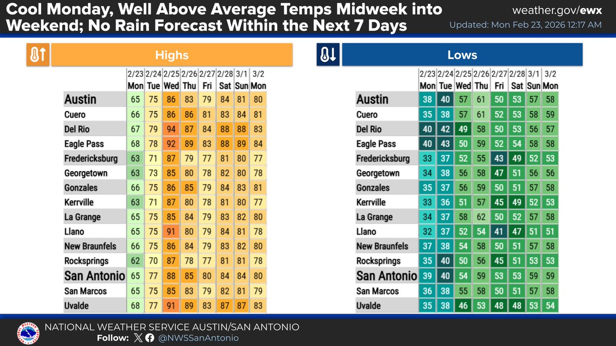
One last cooler day across South Central Texas before Spring-like warmth returns Wednesday-Friday. Highs will climb from the 60s today to the upper 80s and lower 90s Wednesday.
Chilly tonight under mostly clear skies, with a light freeze possible for some as winds become light. After a cool Monday, expect well above average temps midweek through the weekend, with highs mainly in the 80s, but with a few 90s Wednesday. No rain in the 7-day forecast. #txwx
A Red Flag Warning remains in effect for most of the region 10am-9pm today. Gusty northerly winds will combine with very dry air to result in critical fire danger. Mild temperatures are expected today followed by cooler weather Sunday-Monday.
Expect a chilly and breezy night with mostly clear skies. Winds slowly diminish after midnight. Patchy Hill Country freezes are possible early Sunday with wind chills in 20s. Following a cool start to the week, a major midweek warmup will push highs into the 80s to low 90s. #txwx
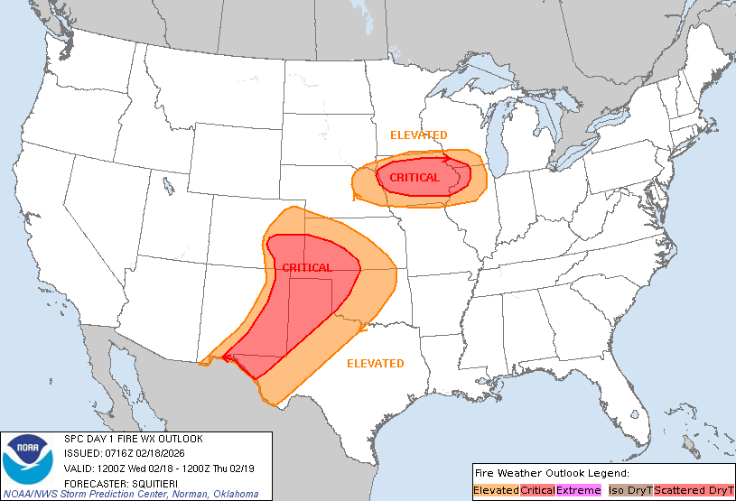
A critical fire weather area has been highlighted in red for portions of eastern New Mexico and west Texas today. Gusty winds, low humidity and dry fuels will support wildfire spread with any ignitions this afternoon.
To stay Weather-Ready and protect yourself from wildfires, visit https://t.co/8bOzSMBEz3.
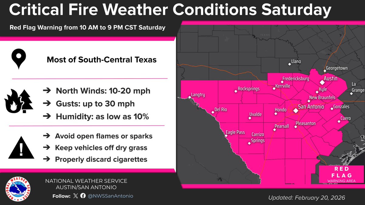
Red Flag Warning issued across South-Central Texas Saturday (10 AM to 9 PM). Gusts to 30 mph and humidity as low as 10% create critical fire weather conditions. Humans cause most wildfires, so avoid open flames, secure tow chains, use grills on pavement, and obey burn bans! #txwx
If things don't cluster up quickly and we get a few discreet supercells, tomorrow could be interesting tornado-wise. Southern Illinois into North KY and W Ohio should have a severe weather plan prepared and ready to go. #wxtwitter
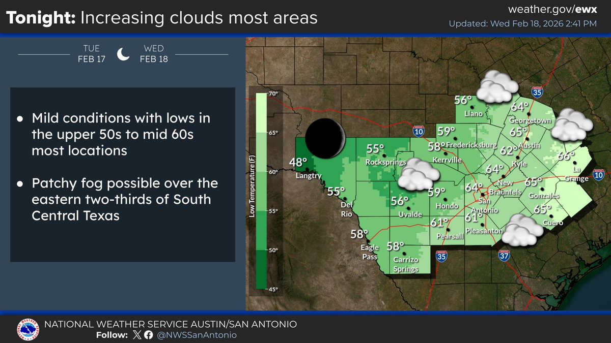
Increasing clouds tonight over the eastern two-thirds of the local area. Forecast lows in the upper 50s to mid 60s most locations. As far as the next few days, warm and dry with a cooler weekend and back to warm next week. #txwx
Our resources are currently responding to 6 active wildfires across the state, including several in the Panhandle.
See smoke or fire? Call 911 immediately.
Active fire map: https://t.co/JiP5HPST9y
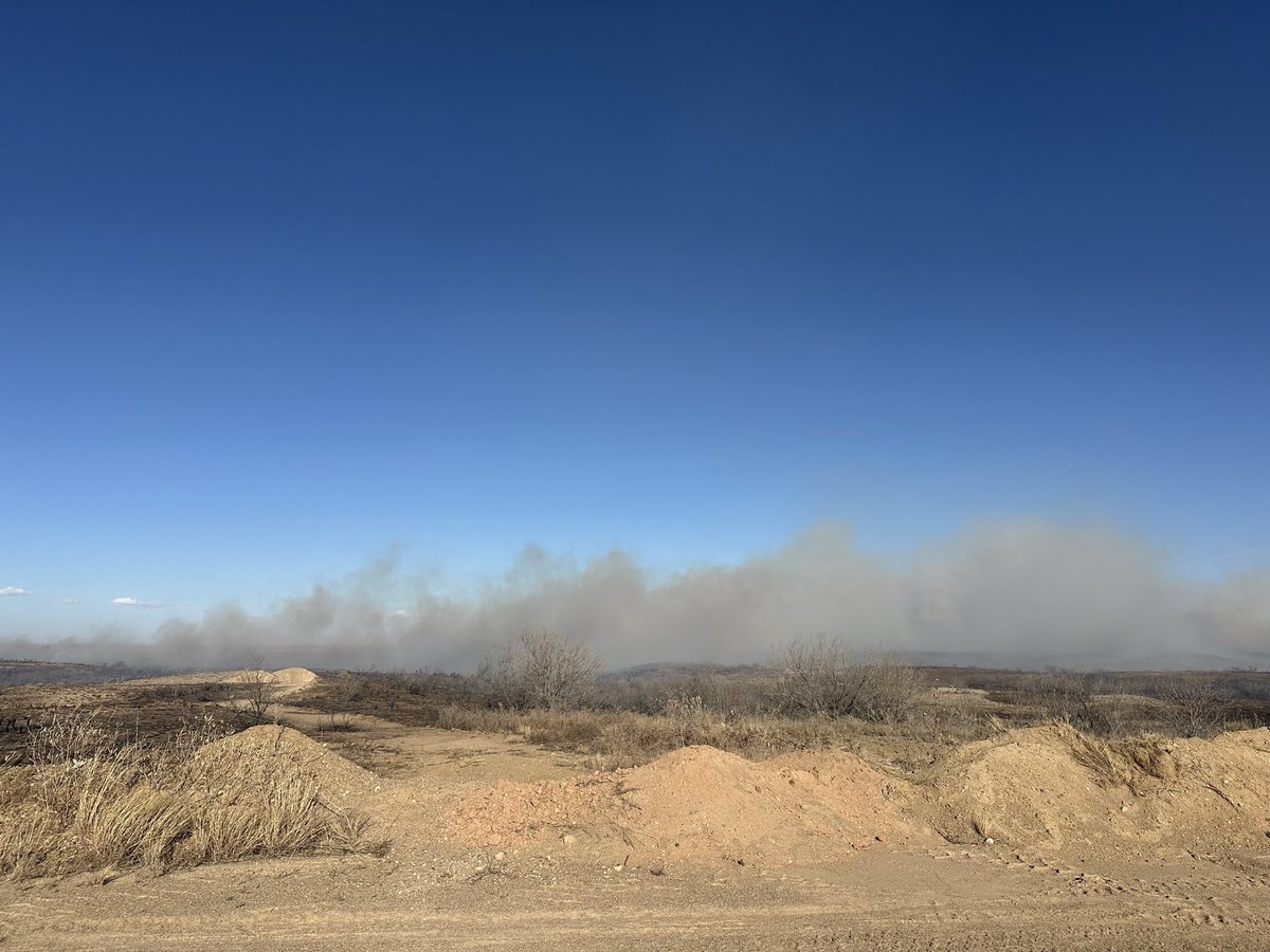
📸 Lavender Fire, Oldham Co. Feb. 17, 2026. Credit: Texas A&M Forest Service
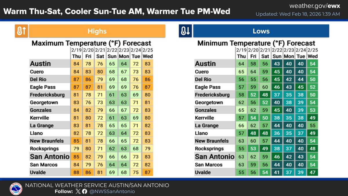
Temperatures remain warm through Saturday. In the wake of frontal passages, temperatures turn cooler by Sunday through early Tuesday. Warmer temperatures return late Tuesday into Wednesday. Cannot rule out a shower or two with the frontal passages. Otherwise, no rain chances.
1:18am CST #SPC Day1 #FireWX Critical: much of the southern high plains, most of iowa, far southwestern wisconsin, and far northwestern illinois https://t.co/Sz3kci5ng7
NUMEROUS fire warnings have been issued from Texas to Kansas, and rapid spreading fire conditions will persist into the night.
Have a plan ready and be prepared to act!
EVACUATION ORDER: Woodward EM: A dangerous wildfire is located southwest of the City of Woodward spreading rapidly northeast. This area is in IMMEDIATE DANGER from wildfires which can cause injury/death, burn down homes/other structures. Do not delay to pack belongings.