Unfortunately, while in Canada, I accidentally drank water at a hotel that was marked unsafe to drink and I’m definitely paying for it now.
I’m calling off today’s chase and heading back to the city tomorrow to recover. Not the outcome I wanted, but health comes first. Appreciate everyone’s understanding.
A widespread heat wave will build across the central U.S. through midweek before shifting to the East Coast, where it peaks on Friday, then slowly ease over the weekend.
An early season heatwave can often be more dangerous and pose a greater risk for heat-related illness. This will be the most significant heat so far this summer for many locations.
The most important things you can do in significant heat are to stay hydrated and interrupt your exposure to the heat by taking breaks out of the sun and/or being in cooled locations.
Visit https://t.co/qk3BcVPDBG for the latest forecast.
Temperatures will be above average for many this week across the Lower 48. High temperatures across the northern and central Plains could be 20-25 degrees above average tomorrow. By Thursday the Northeast will see temperatures well into the 90s.
You can prepare for extreme heat ahead of time: https://t.co/dGBTXbIOd2
7:05am CDT #SPC Day1 Outlook Slight Risk: this afternoon and evening from northeast Colorado and southeast Wyoming into parts of Nebraska and Kansas. https://t.co/TgJgC6cj9Y
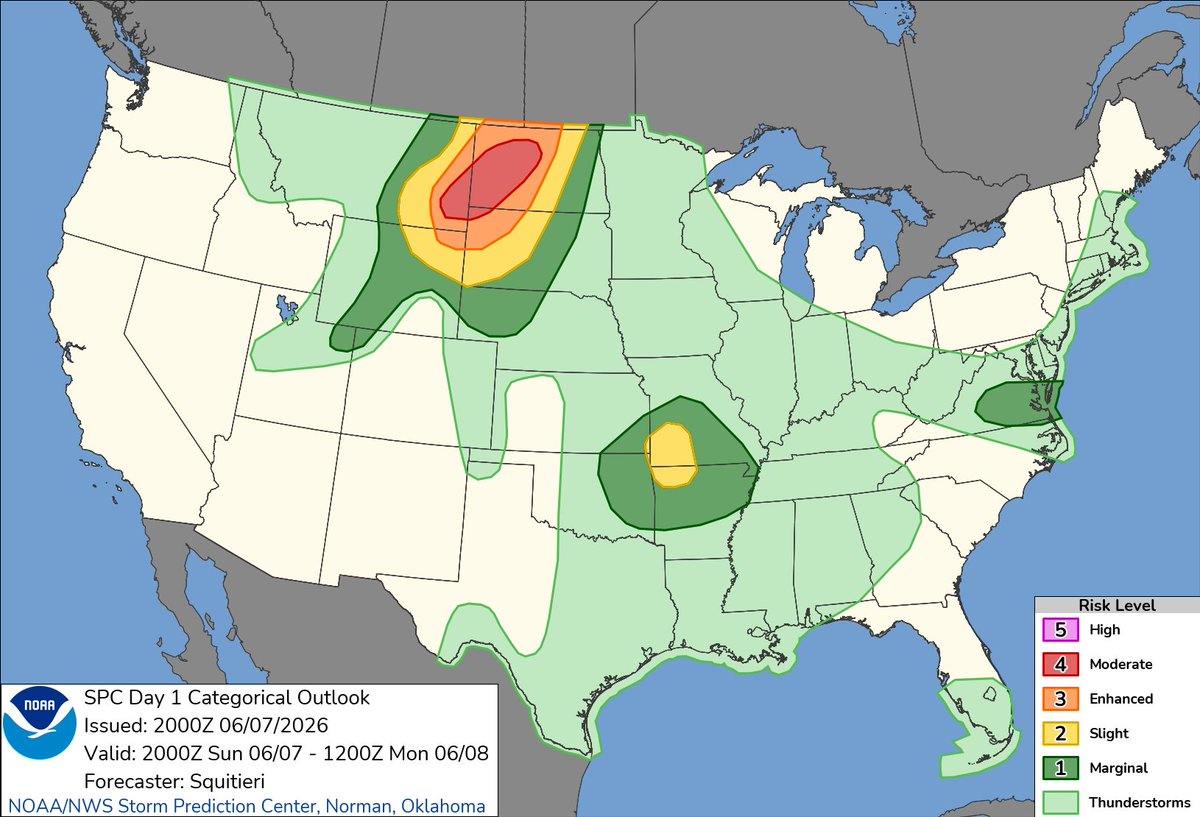
3:02pm CDT #SPC Day1 Outlook Moderate Risk: for portions of southeastern Montana, extreme northwestern South Dakota, western and central North Dakota, https://t.co/TgJgC6cj9Y
Orange Level Tornado Watch Issued for SE SK & parts of SW MB as forecast confidence for impactful wx this PM is high.
Hazards:
Tornadoes (some strong EF2+)
Hail up to 6cm in diameter
Wind gusts to 100km/h
Local rainfall amounts in excess of 50mm
#SKstorm#MBstorm
CASFW - 12:29
Thunderstorms with large hail, severe wind gusts, and a few tornadoes will be possible this afternoon and evening in parts of the northern Plains into upper Mississippi Valley. Visit https://t.co/VyWINDk3xP for details.
Ready to level up your storm-watching skills? ⛈️ We’re hosting an Advanced Weather Spotter Class in Coal Grove, OH (Lawrence Co) on Monday, June 15th! Learn about complex thunderstorm dynamics, advanced structure, and radar interpretation.
Details: https://t.co/2dalS654x0