Most communication failures during a crisis aren��t operational…
They’re communication failures.
After 30+ yrs as a PIO, I created a FREE Crisis Communication Readiness Checklist to help you prepare before incidents happen. Download here: https://t.co/qD60ZTs3Qp
#thepioguy
It's time to level up. Enhance skills, boost value. The challenge: embrace further education and training. The reward: greater potential. #Skills#Education#ThePioGuy#THPRGroup
Viewers looking for more resources can find them at https://t.co/7wUrUiv8BH. It's a great place to learn more and connect with others. #Resources#Community#ThePioGuy#THPRGroup
Media monitoring helps public information officers stay informed. They gather insights to address issues and educate the public effectively. #MediaMonitoring#PublicInfo#ThePioGuy#THPRGroup
The PIO Guy's new podcast delivers essential tips and skills for those stepping into the role of public information officer. It's time to level up those PIO skills. #PublicInfo#PIOTips#ThePioGuy#THPRGroup
🚨Multiple storm clusters, including the risks for derechos, will be possible next week.
Damaging wind gusts and embedded tornadoes will be the main risks with any clusters that are able to become severe.
We will have updates as more data becomes available!
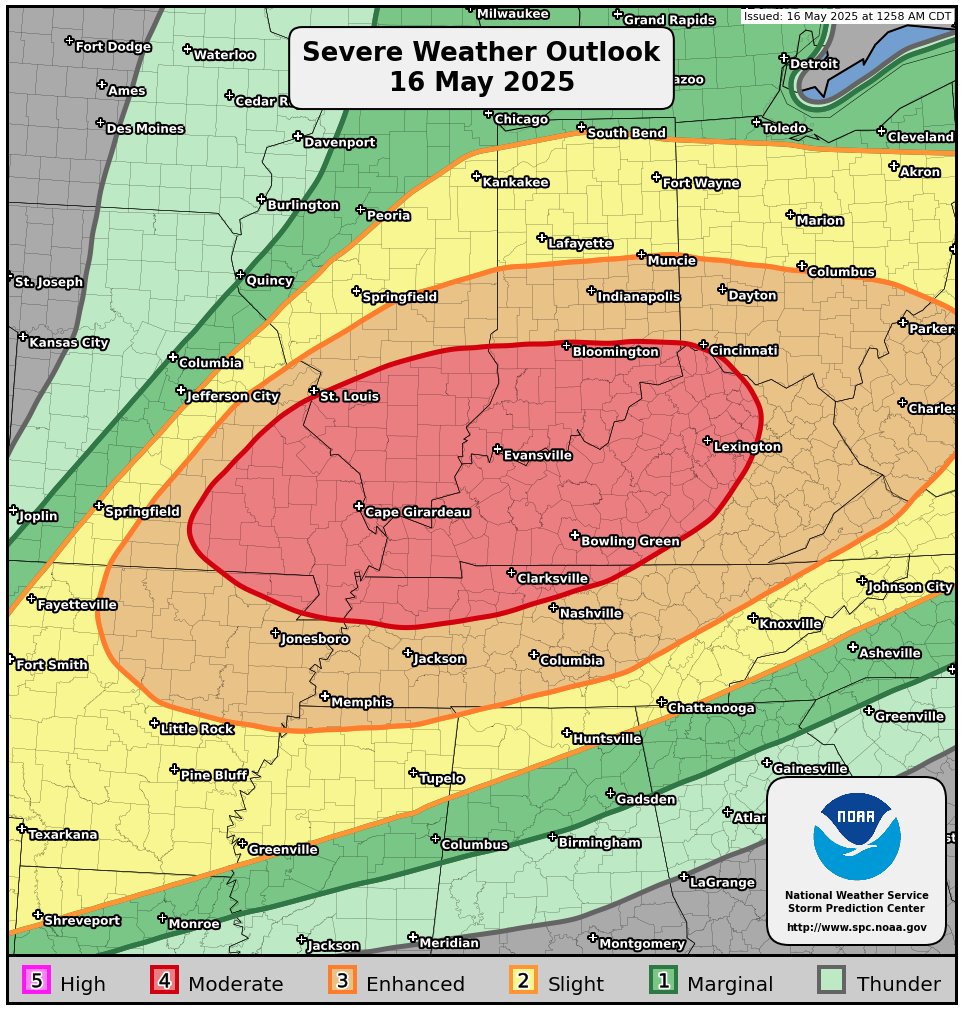
SEVERE WEATHER UPDATE (5/16/25):
Widespread, significant severe weather is likely across S. Indiana, N. Kentucky and S Illinois this afternoon. General timing will be 4PM - 11PM from west to east. Timing for Indy Metro likely 7 - 9PM timeframe.
VERY LARGE HAIL, DESTRUCTIVE WINDS AND A FEW STRONG TORNADOES POSSIBLE IN THE RED AREA!
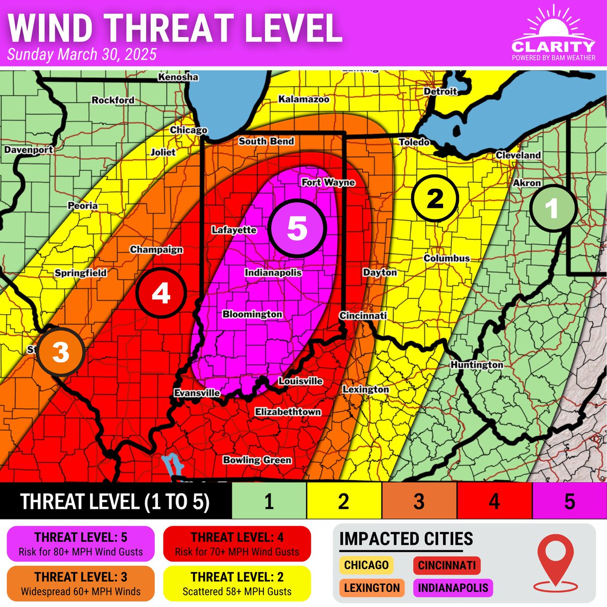
Most concerned for widespread damaging winds this afternoon/evening with storms in central Indiana. Could see some 70-80+ MPH wind gusts. Scattered large hail and a few tornadoes will also be possible.
With how cold we’ve been, the coming days may feel like record heat for late February, but we will still be 15-20 degrees away from any Indianapolis records. Still, the warmth will feel nice, even with windy afternoons. Enjoy! #INwx
Warmer days are ahead! Look for widespread highs in the 50s by Tuesday. Mostly quiet weather conditions are expected, but there is a low chance for rain Monday night. Breezy conditions are also likely during the day Monday with gusts up to 30 mph. #inwx
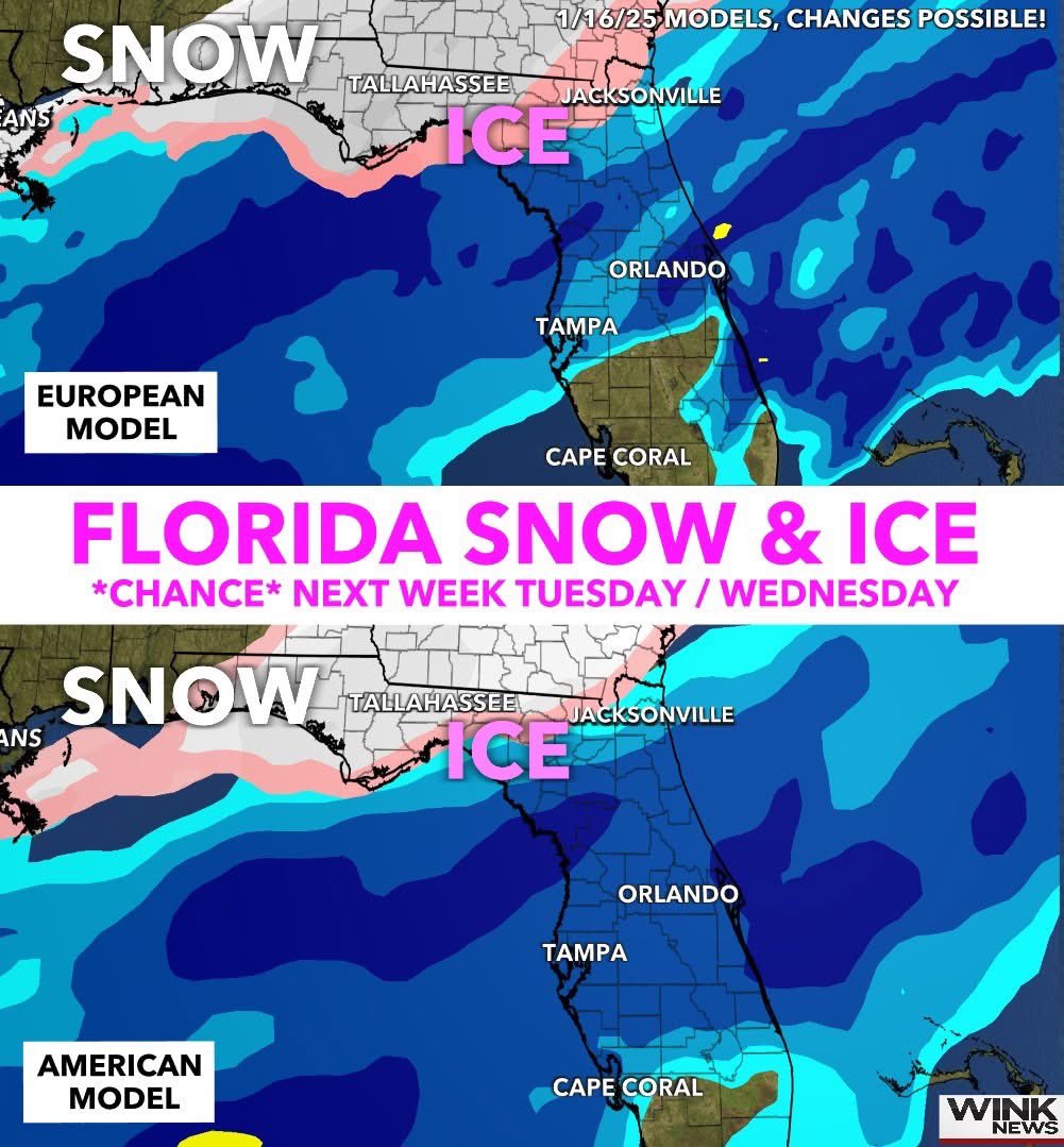
FLORIDA SNOW & ICE *chance* next week on Tuesday / Wednesday. Here's the bottom line as of Thursday: ❄️☃️
1. Normally when #Florida gets cold, we're dry, but next week a storm system could work together with arctic air to produce an area of freezing rain, sleet and even #snow for parts of the state. As you can imagine, the more north you get (colder), the better shot you have.
2. I can't stress enough how tricky this forecast is. This is a possibility and chance for now, not a guarantee yet. A lot of it has to do with the track of the storm system. If it goes more north, we would see just rain...the more south (including in recent model runs) and that opens the potential for wintry weather for some. The reason why I'm bringing it up is we're 5 days out and models have shown some consistency.
3. Too early to talk specifics, totals and how far south the wintry weather could get...if it occurs. Featured below, snow is white, pink is mix or ice, blue is rain.
As always, just like hurricane season, model changes are possible. Look for trends and consistency. I'll continue to keep you updated on WINK News!
- Matt Devitt WINK Weather @WINKNews