@therobdale Well yes. Just seemed you doubted my initial report. I am usually conservative with lots of years of experience. In no way was the wind we experienced 45-50 mph! Definitely an unnerving event/experience trapped on the plane. 😬😉
So the 80 mile an hour winds were hitting the airplane at the gate they finally told us to get off the plane. The plane was moving pretty good and you could start to feel the right wing lift a bit before we got off. #ChicagoMidway@SouthwestAir
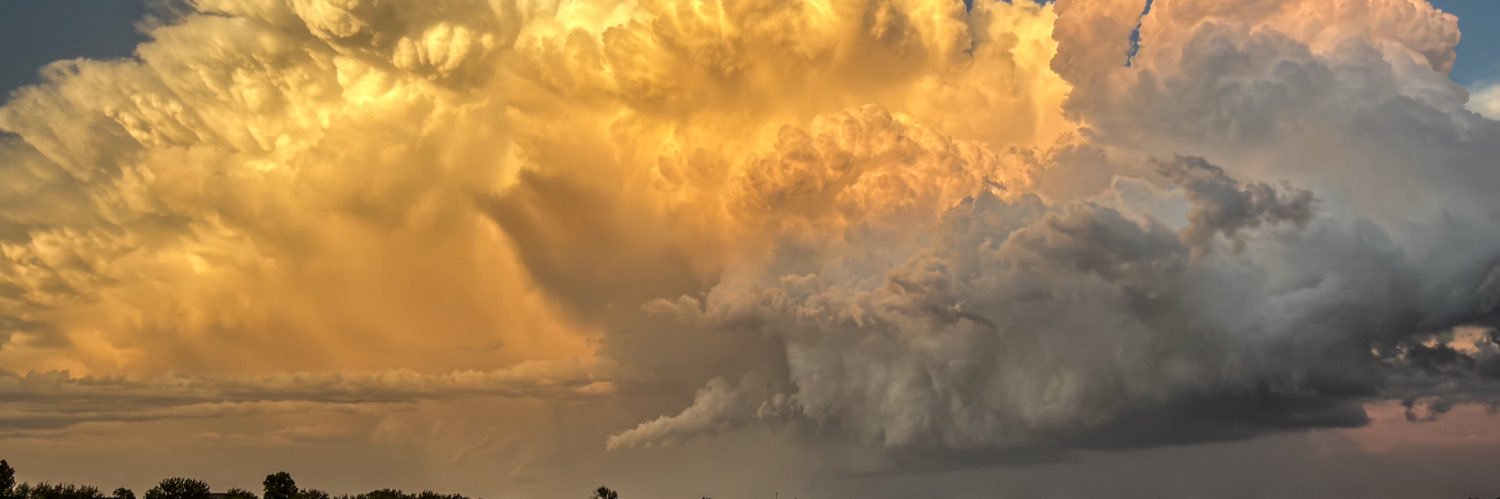
@therobdale An aside from Thursday’s #ChicagoMidway storm event. EF-2 tornado now confirmed, from Hickory Hills (just SW of MDW) to near Midway airport. ASOS wind of 46 mph was north side, so 60-80 mph fits est. in closer proximity (1/2 mi S) at our gate & approaching meso/tornadic circ.
Tornado warned storm with radar estimated 80 mph winds approaching #ChicagoMidway Airport. They won’t let us off the plane we’re at the gate. @SouthwestAir
Sitting on a plane at the gate at #ChicagoMidway. Probably not a good idea to be sitting on a plane with storms with tornado and thunderstorm warnings approaching from the west?! But here we are! 🤷♂️ @SouthwestAir
Chances for storms will push south of #Wichita by Thursday afternoon. Then less humidity & not as warm for south central KS Friday. The heat & humidity return briefly Saturday promoting storm chances again which linger into Sunday as it turns much cooler! #ICTwx#kswx
The better risk for severe storms later this evening is expected to be north of #Wichita. However isolated storms, possibly severe, will be possible further south including Wichita and closer to the Oklahoma border. Stay weather aware this evening! #ICTwx#kswx
Gusty south winds will keep the tropical-feel going Wednesday for greater #Wichita. Severe storms will be possible for much of the area in the evening. Not as warm & less humid Friday! Turning stormy again this weekend before milder & drier weather returns Monday. #ICTwx#kswx
Strong to marginally severe storms will be possible later this evening across portions of south central KS, mainly west of greater #Wichita. #ICTwx#kswx
The tropical-like heat & humidity will continue over greater #Wichita thru mid-week. A chance for severe storms Wednesday evening. Not as warm & less humid by Thursday night & Friday. A chance for storms again over the weekend. Then dry & turning even cooler Monday. #ICTwx#kswx
Storm chances, some possibly severe, later this evening over south central KS still look better just north & east of #Wichita, from Hutchinson to Newton into Butler county. Stay weather aware, even in Wichita, in case storms develop or move a bit further southeast. #ICTwx#kswx
Much warmer Monday thru Wednesday & still humid over greater #Wichita. Mainly evening & nighttime storm chances the next few days. Not quite as warm & less humid later in the week. Then storm chances return by the weekend. #ICTwx#kswx