Hazardous heat returns today and looks to stay at least through early this week across the region. Be sure to stay hydrated and take frequent breaks during any outdoor activities! #nmwx#txwx
We are expected to remain in a quiet and typical summer-time weather pattern for the next couple of days. Here is a reminder that severe weather can still occur especially during early to mid June. #txwx#nmwx#wxhistory
At 8:48 AM CDT, 6 SE Lovington [Lea Co, NM] Emergency Mngr reports Flash Flood. Standing water and flooded roadway on Hwy 18 between Lovington and Hobbs. #nmwx https://t.co/enX8ebtoxP
⛈Rain chances increase this week thanks to a series of disturbances. We will be keeping a close eye out for flash flooding, especially in urban and low-lying areas. A few storms may also become strong.⛈ #nmwx#txwx
It will be hot today with highs rising into the upper 90s to low 100s. Scattered showers and storms develop this afternoon and evening along a dryline and a few could become severe. #txwx#nmwx
It will be hot today with highs rising into the upper 90s to low 100s. Scattered showers and storms develop this afternoon and evening along a dryline and a few could become severe. #txwx#nmwx
Ever wondered why some potentially big severe weather days do not pan out? Check out these two graphics explaining a recent example where severe thunderstorm coverage was largely limited despite the atmosphere looking “primed” for our area! #nmwx#txwx
It will be hot this weekend with highs into the 90s for most locations, and a few 100s in the Rio Grande and Pecos River valleys. No rainfall is expected on Saturday, but isolated to scattered showers and storms are expected again Sunday afternoon and evening. #txwx#nmwx
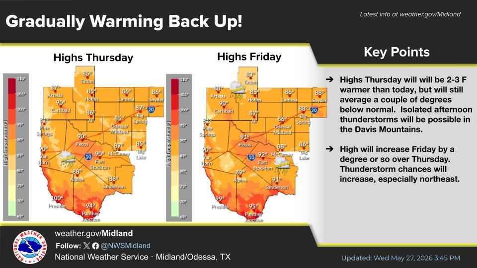
Highs Thursday and Friday will be ~ 2-4 F warmer than today, but will still average a few degrees below normal. Isolated afternoon thunderstorms will be possible in the Davis Mountains Thursday. Thunderstorm chances will increase Friday, especially northeast. #txwx#nmwx
Here is a morning update on the severe weather potential today. The greatest risk of severe storms will be over portions of the Permian Basin to Lower Trans Pecos beginning late this morning into the early evening hours. Ensure you have multiple ways to receive warnings today!
Protect yourself and those you love by wearing your sunscreen every day–even when it’s cloudy. Regularly reapply every two hours or after you sweat or get wet! #DontFryDay#HeatSafety
Another round of storms is expected today across the Permian Basin to Lower Trans Pecos. A storm or two may become strong to severe especially for areas in the northern and eastern Permian Basin. Large hail and damaging winds will be the primary hazards with the strongest storms.
Heat can be a deadly weather hazard, even outside of heat waves. In fact, most heat-related deaths occur during milder weather. Stay #WeatherReady! #HeatSafety https://t.co/VgkcCbCcyU
Special Weather Statement [wind: 55 MPH, hail: 0.00 IN] for Eddy County Plains, Southern Lea County [NM] and Loving, Reeves County Plains, Winkler [TX] till 5:15 PM CDT https://t.co/WkPv9zKbNf
Strong to severe storms will be possible for locations within the highlighted locations until 10 PM CDT this evening. Not all locations will see storms due to isolated coverage. Have multiple ways to receive warnings! #txwx


![iembot_maf's tweet photo. At 8:48 AM CDT, 6 SE Lovington [Lea Co, NM] Emergency Mngr reports Flash Flood. Standing water and flooded roadway on Hwy 18 between Lovington and Hobbs. #nmwx https://t.co/enX8ebtoxP https://t.co/vqJbrKamNc](https://pbs.twimg.com/media/HJ_FaIQXcAE2FN1.jpg)


![iembot_maf's tweet photo. At 4:44 PM CDT, Tatum [Lea Co, NM] Emergency Mngr reports Tstm Wnd Dmg. Power outages reported in Tatum associated with straight-line wind gusts. #nmwx https://t.co/eK011mfv5z https://t.co/nqOdf2ggUp](https://pbs.twimg.com/media/HIZFOKtWcAI_kU4.jpg)


![iembot_maf's tweet photo. Special Weather Statement [wind: 55 MPH, hail: 0.00 IN] for Eddy County Plains, Southern Lea County [NM] and Loving, Reeves County Plains, Winkler [TX] till 5:15 PM CDT https://t.co/WkPv9zKbNf https://t.co/aIMFFMerIH](https://pbs.twimg.com/media/HIY-2CPWIAE6cIN.jpg)


