***MUST SEE TV***
Eyewitness account of the F-35 Crash. I am warning y'all, you ain't ready for this.
I have had about 2 dozen people send me this on Facebook. I am in stitches. Deceased. I have tears in my eyes from laughing so hard.
Hurricane #Idalia Advisory 13: Idalia Now a Category 2 Hurricane. Life-Threatening Storm Surge and Hurricane Conditions Expected Along Portions of the Gulf Coast of Florida Tonight and Wednesday. https://t.co/tW4KeGe9uJ
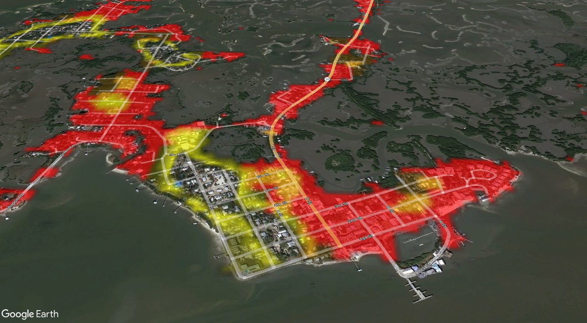
A mandatory evacuation order has been issued for those along the coast of Levy county. And that includes the people of Cedar Key.
Here's my advice - LEAVE! If you choose to ignore the mandatory evacuation order and you live on Cedar Key, I want you to write your name and SSN in sharpie on your wrist. It makes it easier for the first responders to know who you are.
Yeah, that's some harsh words - I know. But I don't use it lightly. I've covered several hurricanes where surge values eclipse 10 feet. #Idalia may attempt to bring 12 feet of ocean water on normally dry ground. That's not survivable if you live in Cedar Key.
Please, for your own safety, if you live here, evacuate and listen to your officials. #FLwx #stormsurge #CedarKey
#IDALIA UPDATE 🌀 As of 11 AM Monday, Hurricane and Storm Surge Warnings have been issued for portions of the Florida West Coast, including Tampa Bay. A Major Hurricane is possible at landfall Wednesday morning between St Marks to Tampa Bay. Highest probability is closer to Cedar Key.
SOUTHWEST FLORIDA : I am not expecting a local landfall based on current models. The eyewall, the worst part of the storm, will be up the coast and away from our area. "Are you sure??" Every storm is different. Ian models continued to trend east and east and east leading up to its eventual landfall in Southwest Florida. Consensus models, often the better performing, recently haven't done that and in fact, have shifted back west a bit. It's called the windshield wiper effect. Instead of focusing on every east and west shift, look for consistency and the average. Which is right now pointing towards where the NHC cone is. What Southwest Florida will experience are impacts typical on the eastern "dirty side" of a storm and more comparable to a tropical storm...which is why we are currently under a Tropical Storm Warning. Locally, you do not need to put up Hurricane Shutters based on the current forecast. Here is what I'm expecting in Southwest Florida:
👉 RAIN: 1 - 3" on average. I do have a few models showing the potential of what's called "training," where narrow bands of heavy rain move over the exact same spot. In those limited and isolated spots, 6"+ of rain *if* they set-up.
👉 WIND: West of I-75 (coast) wind will be sustained during the storm's peak between 20 - 35 mph, gusting 35 - 55 mph. Few occasional gusts to closer to 60 mph possible right at the beach during squalls. East of I-75 (inland) wind will be sustained during the storm's peak between 15 - 25 mph, gusting 25 - 45 mph. I'm not expecting widespread power outages, but a few isolated areas can't be ruled out.
👉 SURGE: 2 - 4 feet Tuesday evening into Wednesday morning with some coastal flooding. Unfortunately Idalia's arrival will also be coinciding close to the 2nd August Full Moon, which produces greater tidal swings. Lower low tides, but also higher high tides.
👉 TORNADOES: Will be possible because of our position on the eastern "dirty side" of the storm with enhanced twist and spin aloft. You're in good hands though with WINK Live Doppler 3X, Southwest Florida's Most Powerful and Accurate Radar. The minute any cell starts to spin, you'll immediately know about it from our WINK Weather Team.
👉 OTHER IMPACTS: Higher surf and beach erosion.
We will feel impacts from this storm in Southwest Florida, but not to the caliber or intensity of Hurricane Ian. For those struggling with PTSD after the storm, I hope that will bring comfort. If you're reading this from an area in a Hurricane or Storm Surge Warning along the Florida West Coast, please wrap up plans TODAY. Don't wait. If told to evacuate because of the potential of life-threatening storm surge, please do so. Make sure to stick with WINK News in Southwest Florida for your #1 source for Idalia updates. I'll be with you every step of the way with the latest with no hype, just facts weather. @WINKNews
It’s the $150,000 Cash App Giveaway. Follow
@cashapp and QRT this with your $cashtag to enter.
This giveaway is so big because it’s full of secrets. #CashAppPresents
Severe thunderstorms will be possible this afternoon into this evening across the forecast area, particularly along and north of the Interstate 20 corridor where damaging wind gusts up to 60 mph, hail up to the size of golf balls, and tornadoes will be possible.
Zebra Cake Boost is our favorite guess. But right now we are giving a 99% off Boost to use at Sephora (max $100 off). QRT this with your $cashtag for a chance to win. Must be following @cashapp to qualify. #CashAppBoostWeek
Maybe our hint was too easy. You got it, we’re dropping a 99% off Target Boost right now. QRT with your $cashtag to enter. Must be following @cashapp to win. #CashAppBoostWeek