The National Weather Service in Aberdeen has issued a
* Severe Thunderstorm Warning for...
Eastern Jones County in central South Dakota...
* Until 545 PM CDT.
* At 500 PM CDT, a severe thunderstorm was located near Westover, or
7 miles south of Murdo, moving northeast at 30 mph.
HAZARD...60 mph wind gusts and quarter size hail.
SOURCE...Radar indicated.
IMPACT...Hail damage to vehicles is expected. Expect wind damage
to roofs, siding, and trees.
* This severe thunderstorm will be near...
Westover around 505 PM CDT.
Draper around 520 PM CDT.
PRECAUTIONARY/PREPAREDNESS ACTIONS...
For your protection move to an interior room on the lowest floor of a
building.
A Tornado Watch remains in effect until 1100 PM CDT for central South
Dakota.
🚨 Now Hiring – Part-Time Sales & Admin Rep 🚨
Tea Storm Chasers is looking for a part-time Sales & Administrative Representative to join our team!
• 20-30 hours per week
• Weekdays between 8 AM – 5 PM NO WEEKENDS
💰 Pay:
• Base pay + commission for sales
• Administrative work is paid hourly
🗂️ Role Includes:
• Commission-based sales & client outreach
• Paid hourly administrative support
• Emails, scheduling, and office tasks
We’re looking for someone reliable, organized, and comfortable working with people.
📩 Interested?
Send us a message or email with a short intro and your experience.
TORNADO WATCH ISSUED UNTIL 11 PM CDT
● Tornado Watch for portions of
– Central and Eastern South Dakota
– Far Western Minnesota
– Southeast North Dakota
● Effective this Wednesday afternoon and evening from 405 PM until 1100 PM CDT.
● Primary threats include
– A couple tornadoes possible
– Scattered large hail likely with isolated very large hail events to 2 inches in diameter possible
– Scattered damaging wind gusts to 70 mph possible
SUMMARY
Thunderstorms are expected to develop along and ahead of a cold front moving southeastward across the central Dakotas. If a discrete storm mode can be maintained, environmental conditions support supercells capable of all severe hazards, including tornadoes and isolated very large hail. Storms along the front will likely be more linear, with damaging gusts as the primary risk.
REMEMBER
A Tornado Watch means conditions are favorable for tornadoes and severe thunderstorms in and close to the watch area. Persons in these areas should be on the lookout for threatening weather conditions and listen for later statements and possible warnings.
A Mesoscale Discussion has been put out for our region! An 80% chance of a Weather Watch is likely for this later afternoon/evening hours! Severe Weather is likely across central & eastern South Dakota! All modes of severe weather will be possible with large hail, strong winds, & tornadoes! We will monitor the latest and bring you the latest information!
Sign Up for our NEW WeatherCall system here: https://t.co/dRjV7MgN6O
From NWS: Tornado Watch for Jones, Kingsbury, Lake, Lyman, McCook, McPherson, Marshall, Mellette, Miner, Roberts, Sanborn, Spink, Stanley, Sully, Todd and Tripp County in SD until 11:00pmCDT/10:00pmMDT.
SiteWorks provides the highest quality Sewer and Water install services in the Sioux Falls area! We are searching for motivated, detail oriented individuals that put the customer first! We are now hiring general laborers, pipe layers, top guys, as well as equipment operators (Excavator, Loader, Dozer).
Whether you are new to the industry and looking to be trained, or have experience in construction we would like to talk with YOU about a career at SiteWorks!
Reach out to Bay - 605.321.6680
⛈️ **Weather Update for This Afternoon & Evening**
We're expecting a few storms to begin developing after **4:00 PM** across portions of the region. While not every storm will become severe, conditions will be favorable for a few stronger storms to develop.
The **main system is expected to organize and strengthen after 7:00 PM**, but the time period we need to watch most closely is **between 4:00 PM and 7:00 PM**, when initial storm development could produce hail, damaging winds, and possibly a tornado or two.
Our Weather Center will be fully staffed and ready to monitor conditions throughout the day and evening. If severe weather develops, we'll provide updates both here and live on our YouTube channel.
📺 https://t.co/BUqix4iHTv
Be sure to share this post with your friends and family so they can stay weather aware today! 🌪️⚠️
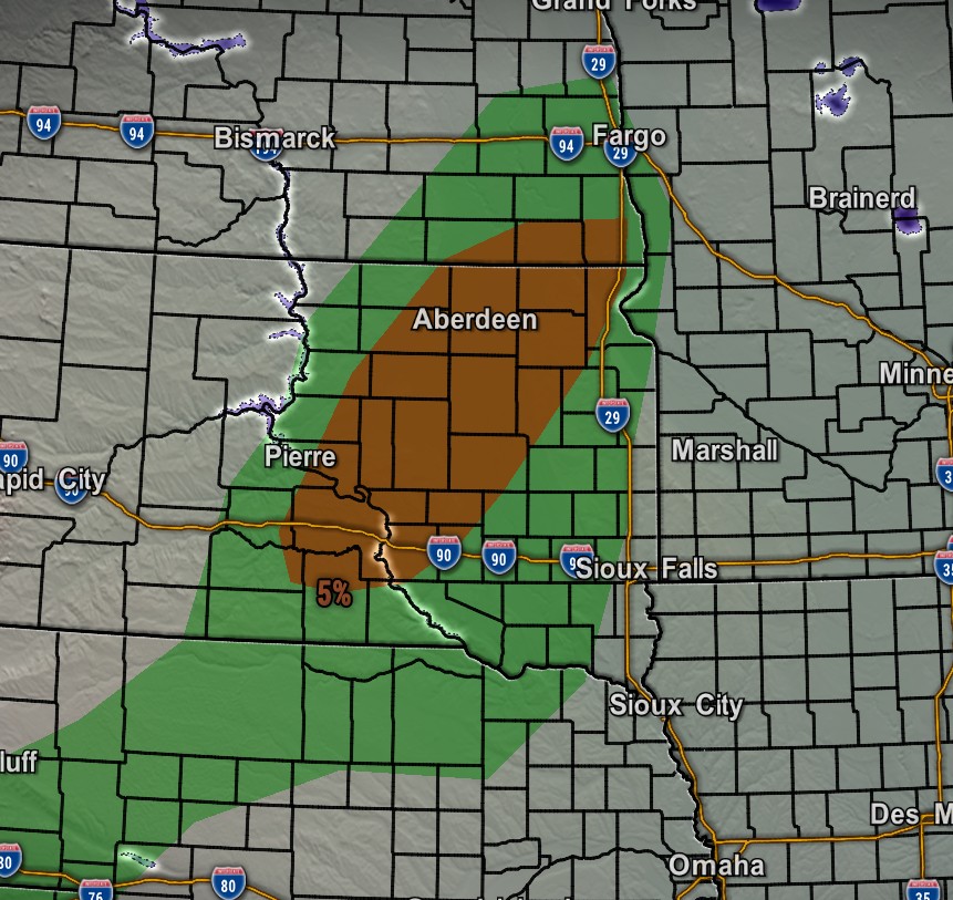
🌪️ Do you have friends or family in the 5% or 2% tornado risk areas today?
Now is the time to share this post and make sure they're prepared. Our chase teams will be monitoring conditions throughout the day, and our Weather Center will be **fully staffed and ready** to bring you live updates if severe weather develops.
Be sure to subscribe to our YouTube channel so you don't miss any live coverage:
👉 https://t.co/BUqix4iHTv
Stay weather aware, have multiple ways to receive warnings, and follow Tea Storm Chasers for the latest updates throughout the day and evening! ⚠️🌩️
🌪️ **Tornado Outlook for Today**
The SPC has a **5% tornado risk** in place mainly from **northern Nebraska into eastern South Dakota, far southeast North Dakota, and western Minnesota**. This is the area where a few storms may stay more isolated and rotate, especially later this afternoon and evening.
A broader **2% tornado risk** surrounds that zone, meaning the tornado threat is lower but not zero. Large hail and damaging winds will also be possible, so make sure you have multiple ways to receive warnings and be ready to take shelter quickly if a warning is issued.
We’ll be watching this closely and will keep you updated. Turn on alerts and follow Tea Storm Chasers for updates! 🌪️⚠️
🔥 Weld with the best! Williamson Supply offers welding gas deliveries, pressure washers, wild wheelie torch carts & tools. 🧰 Mention this ad for FREE delivery! Call us at 507-853-4742. #WeldingSupplies#WilliamsonSupply#FreeDelivery
🔥 Weld with the best! Williamson Supply offers welding gas deliveries, pressure washers, wild wheelie torch carts & tools. 🧰 Mention this ad for FREE delivery! Call us at 507-853-4742. #WeldingSupplies#WilliamsonSupply#FreeDelivery
Spacious, well-maintained home in a great location! Featuring generous living space, functional layout, and plenty of room to make it your own. Close to parks, shopping, and everyday conveniences.
More info here: https://t.co/AAHC1Ld8Ym
Experience. Design. Decide.
Because blueprints only tell part of the story.
Walk Your Plans lets you experience your home in real scale before construction starts — helping you catch changes early and feel confident in every decision.
Contact Information -
Website: Walk Your Plans Sioux Falls
Email: [email protected]
Phone: 605-601-0927