🚨CODERED ENROLLMENT INFORMATION🚨
CodeRed alerts from us and all of our cities use the following phone number. THIS INCLUDES THE AUTOMATED WEATHER ALERTS FROM CODERED.
THE PHONE NUMBER IS +1 (206) 536-3695.
Please add this number to your known contacts so you recognize it and answer it!
You can enroll by calling 903-813-4231 or by clicking the following link: https://t.co/79Nl6uxbt1
Please be very cautious if you have to drive today and tomorrow. Our local streets still are frozen and are treacherous. We also have the potential for freezing frog and single digit temperatures tonight.
🚨IMPORTANT CODERED UPDATE🚨
CodeRed alerts from us will now come from a new phone number.
THE NEW PHONE NUMBER IS +1 (206) 536-3695.
Please add this number to your known contacts so you recognize it and answer it!
Please plan to receive weather alerts in another manner. As we always say, HAVE MULTIPLE WAYS to receive warnings of severe weather. Today would be a good day to check the batteries in your “weather – radio”
Stay tuned into local stations for weather forecasts and updates.
ALERT
Emergency notification system outage: CodeRED weather warnings may not work tonight or the next 48 hours.
If you rely on our CodeRED weather warnings for Flood, Severe Thunderstorm and Tornado Warnings, the system is currently experiencing difficulties.
A few storms with damaging wind gusts are possible late this afternoon through the evening. Some storms may also contain small hail and frequent lightning. Scattered showers and storms will continue overnight into Saturday morning, but severe weather is unlikely. #dfwwx#ctxwx
We will see scattered showers and storms and some could be strong/severe storms from 4pm-11pm. Hail and damaging winds will be the main threats through the evening hours.
Have multiple ways to receive warnings, stay weather aware, and stay safe.
We are experiencing outages to our 9-1-1 system across the area. If you are in Grayson County and your 9-1-1 call does not go through right away, hang up and dial
903-813-4411.
🚨*Tonight's Severe Threat Update*🚨
We have outlined the area with the greatest threat for 80+ mph winds (pink hatching). You need to PREPARE for widespread damaging winds, but know NOT EVERYONE will see 80+ mph, this will occur in "pockets" along the line! #dfwwx#ctxwx#txwx
Hot and humid conditions will prevail this weekend, with afternoon highs in the 90s both days. Peak afternoon heat index values will rise up to 105 degrees each afternoon. Make sure to drink plenty of water and avoid excess time outdoors #dfwwx#ctxwx
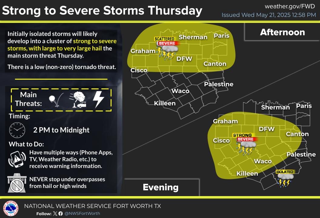
SEVERE WEATHER EXPECTED THURSDAY AFTERNOON
Initially isolated storms tomorrow afternoon may change to a cluster of strong to severe storms with large hail the main threat.
Storms will shift south through the evening, with the main storm timing between 2 PM and midnight.
Last week, we wrapped up our latest round of Community Emergency Response Team (CERT) training.
We are thankful for these participants spending their evenings with us in order to become more prepared!
⚠️ HEADS UP! ⚠️
The potential for severe weather has increased for Sunday. Strong/severe storms will be possible beginning Sunday morning, w/ severe storms increasing thru the afternoon. All hazards may be possible, so stay weather aware & have multiple ways to receive warnings!
Join us this Tuesday for the Grayson County SKYWARN storm spotter training class! The class will begin at 6 pm in the Center for Workplace Learning Auditorium in Denison, and it is FREE and open to anyone who would like to attend. We hope to see you there! #txwx
Texoma Regional Blood Center is experiencing a critical blood shortage. ALL BLOOD TYPES ARE NEEDED.
Please donate at TRBC! If you are unsure if you are eligible or have any questions please call 903-893-4314.