Areas of dense fog continue for portions of south central Nebraska this morning, mainly W of Hwy 281 and along the state line. Some improvement as arrived around Grand Island, north and east. The Dense Fog Advisory will expire at 9AM, possibly sooner for Hastings and points E
There is a Slight Risk (level 2 of 5) for severe storms late this afternoon and evening. While exact placement and
coverage is not entirely clear at this time, IF storms were to form, the primary hazards would be golf ball hail and wind gusts up to 65 MPH. Iso tornado also poss
An active upper level pattern and embedded disturbances will keep periodic chances for storms in the forecast for the rest of this week. The main chances look to generally favor later in the day and into the evening and overnight hours. #newx#kswx
A few showers and an isolated T-storm may impact western portions of the forecast area this morning, with another round of more widespread thunderstorms expected to cross the plains later this evening and into the overnight hours. Some severe storms are possible! #NEwx#KSwx
Dry conditions are forecast across the area today, with partly cloudy skies and gusty southeasterly winds. A complex upper level pattern is expected to develop as we get into the mid to late week time frame, bringing chances for scattered showers and thunderstorms. #newx#kswx
The coverage of showers and non-severe thunderstorms will increase through the day today with the best overall potential coming overnight between mainly 3-11 AM Friday morning. These showers/storms will come to a close Friday Afternoon. #newx#kswx
Three tornadoes occurred on Sunday, May 17th. Below are graphics talking more about the two damaging tornadoes. There was also one brief touchdown that caused no damage. A link to the Public Information Statement with more about all 3 can be found here: https://t.co/o6q4P4NlE2
Today is Day 2 of #HeatSafety Week, where we will share tips on how to stay safe in the heat!
Heat deaths are preventable; take action to protect yourself and your loved ones —
🆒stay cool
💧stay hydrated
👥check on your neighbors.
Learn more at https://t.co/3eD0BQy9R1
🌡️Heat Safety Week ☀️: Warm temperatures can quickly rise to dangerous levels in summer, especially in in parked cars.
⚠️ NEVER leave people or pets alone in a vehicle
💧 Drink plenty of water
👕 Wear loose-fitting, lightweight clothing
🆒 Spend time in air conditioning or shade
Severe storms will be possible this afternoon for areas south and east of the Tri-cities. Storms will develop between 3-6PM, clearing out of the area by around 9PM. The strongest of storms may carry large hail, wind gusts up to near 60 MPH or even an isolated tornado. #newx#kswx
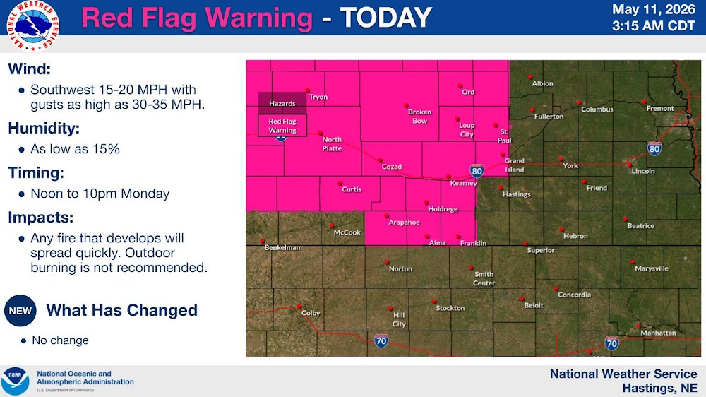
The potential for severe weather returns today and Monday afternoon. The strongest storms may be able to produce large hail with damaging thunderstorm wind gusts. A Red Flag warning will be in effect across a few counties near and south of the state line from 1-9PM today.
The potential for severe weather will return to at least a portion of the area each day through Monday. The strongest storms may be able to produce hail up to the size of baseballs with damaging wind gusts up to 70 MPH. An isolated tornado or two may be possible. #newx#kswx
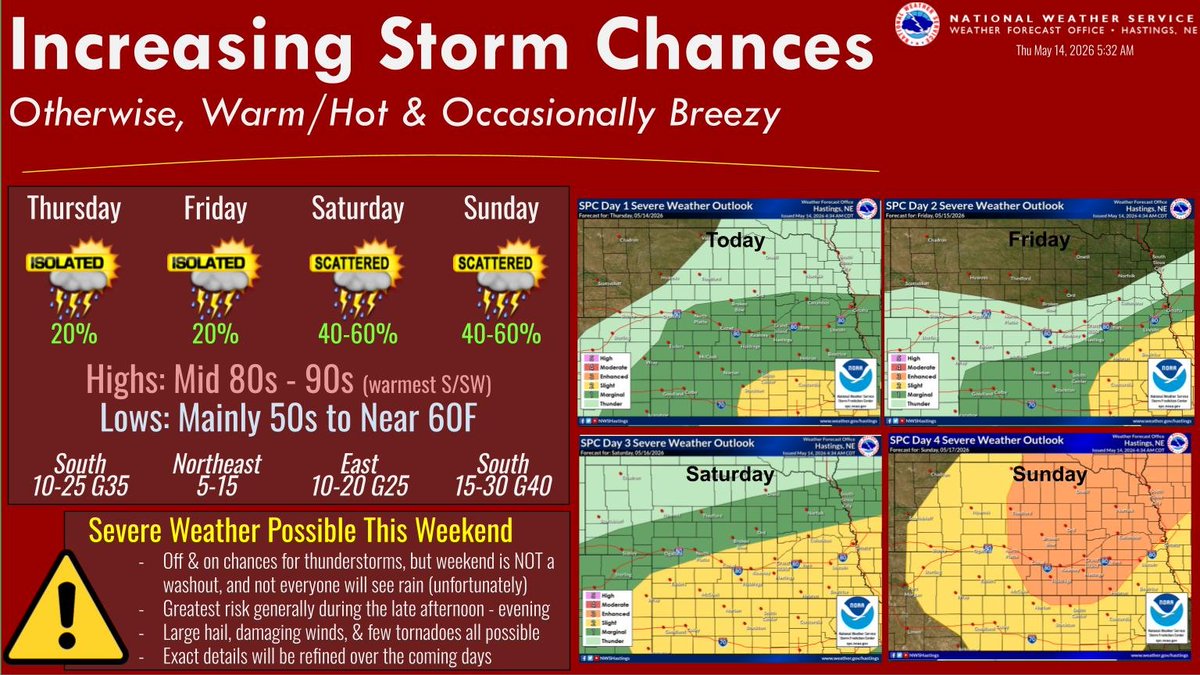
Main story the next few days will be increasing chances for thunderstorms. The greatest severe weather threat will be during the late afternoon and evening hours this weekend. Details on exact coverage & severity remains uncertain. Otherwise, warm/hot & occ breezy #NEwx#KSwx
High temperatures this week will range from the upper 70s to the mid 90s. Rain and storm chances (20% to near 50%) come back into the forecast this weekend #newx#kswx.
A Red Flag Warning remains in effect for portions of Nebraska today. Warm, dry, and breezy conditions are expected through the rest of the week as well. #NEwx#KSwx
- Sprinkles will move through early this morning, but otherwise today will be dry with temps climbing into the 70s.
- A few showers/t-storms are expected Sat.
- Early next week will be dry, breezy, and warm, leading to an increasing fire weather threat.
#NEwx#KSwx
Highs today will be in the 50s with scattered showers possible this morning for southwestern portions of the area. Patchy frost is possible tonight for western portions of the area. Warmer and sunny on Thursday and Friday with highs in the 70s.
Highs in the 50s and 60s today. A few scattered showers/storms are possible across north-central Kansas this afternoon. Widespread frost/freezing conditions are possible tonight with lows near-below freezing. Highs in the 70s and 80s this weekend. #NEwx#KSwx
Showers and an isolated thunderstorm or two are possible (15%-45% chance) for mainly north central Kansas today. Light rain showers/sprinkles are possible (15%-20% chance) on Friday. High temperatures will range from the 50s to the 70s today through Friday. #newx#kswx
There are various chances of showers and thunderstorms (non-severe) today through Thursday. There are frost/freeze concerns each night from tonight through Friday night. #newx#kswx