I have seen God work in so many ways in my life and I can't help but sit here and think "I don't deserve any of these opportunities." That shows me how good my God is and how much he loves me.
Tornado sirens shouldn’t be tested when there is an impending threat of severe weather. Too many people wait for a siren to go off as their source of warning (which should never be the case). Have multiple ways to receive a warning!
Southern TN/Northern AL…this is likely the most difficult wintry forecast that I’ve seen. Just be prepared for a potential wintry mess. There are a lot of details we may not know until the onset of the event. Never a bad idea to prepare for at least 2-3 days. Frigid next week.
Tornado Watch for Madison and Limestone counties in AL and for Lincoln, Moore, Franklin, Bedford, Coffee, Rutherford, Giles, Marshall, and Williamson counties in TN until 10:00 AM. Stay weather aware!
I would like to add that this could be a multi-round event for north AL and middle TN. If storms can break a capped environment pre-dawn, then we will have major issues before the main round moves in around 12pm. It is so important to stay weather aware Saturday.
Be sure you are paying close attention to the weather for the next 36 hours. A severe weather outbreak is possible for the region. All modes of severe weather including strong, long-track tornadoes, destructive winds, hail, and flooding are possible.
https://t.co/1biOjvAUk8
A significant severe weather event is shaping up for most of us in the southeast Saturday. This looks to come in as two rounds with the potential for strong, long-track tornadoes, large hail, destructive winds, and flash flooding. Use today as preparation
https://t.co/RU3qzWEJLX
Be sure you are prepared for the potential of severe weather Saturday AM through Saturday PM. All modes of severe weather are possible. Still waiting for high-res guidance to give a better idea of small-scale features that are detrimental to this forecast.
https://t.co/n9MGEp1mDB
Hazardous Weather Forecast published concerning tomorrow's severe storm and gradient wind gust threat for northern AL and middle TN. Non-thunderstorm gusts between 40-55 MPH are possible. An isolated tornado cannot be ruled out. Be prepared!
https://t.co/J1Es0BjbLi
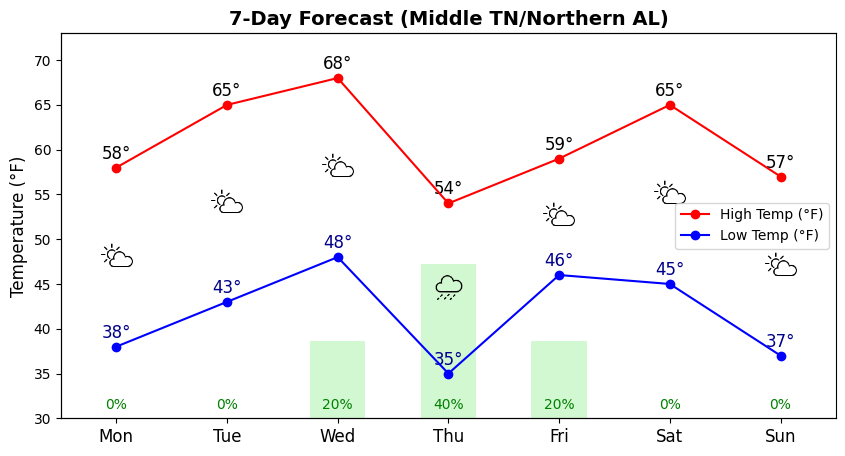
Generally quiet this week. Next chance of rain late Wednesday night into Thursday morning. Near 70 on Wednesday with a temporary drop in temperatures Thursday. Severe weather or winter weather is not expected within the next 7-10 days.
We look good heading into the weekend and early next week. Our next chance for rain looks to come Wednesday into Thursday. The chance is low at this time, and it is probable that some locations miss out on any precipitation. Close to 70 by Tuesday.
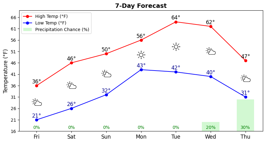
We will stay cold thru tonight here in middle TN. A gradual warm-up begins later this weekend. Our next chance of rain looks to be around mid/late week, however, that chance is relatively low. We cool down again with this next front but shouldn't be nearly as cold as we are now.
Tornado Watch issued for all of the TN Valley. Damaging winds will be the main threat. Isolated tornadoes cannot be ruled out. This is a huge watch. The probs are concerning, but this watch also includes areas that were originally in the more significant risk. Stay weather aware.
NWS Huntsville issues a Winter Storm Watch for the entire valley for Friday. Expecting a major winter storm to impact the area. Heavy snow is likely for most of us with accumulations between 3-5 inches. Locally higher amounts are certainly possible. Avoid travel Friday