Big news! 🌎 We launched a new website 🎉 This is a key step in making climate data & seasonal forecasts more accessible for all Washingtonians. Explore our new look & find the info you need: 🔗 [https://t.co/VMfhgw1AD5] #ClimateResilience#WAClimate
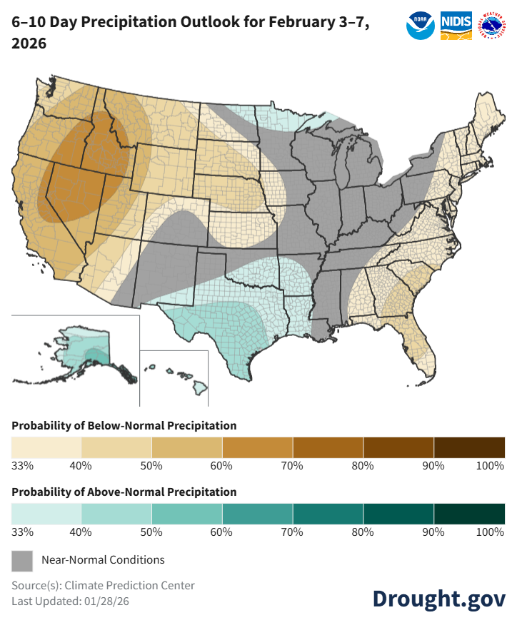
Next week looks relatively dry for the East and West + Northern/Central Plains. Better precip chances in the Southern Plains, a bit of the Upper Midwest, + AK/HI.
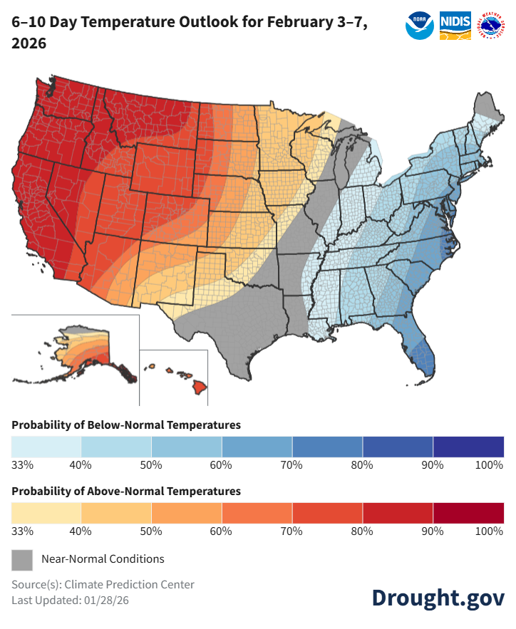
Above-normal temps for the West and most of the Plains. East stays cold. https://t.co/s8Wz6Q8Evy @NOAA@NWS@NWSCPC
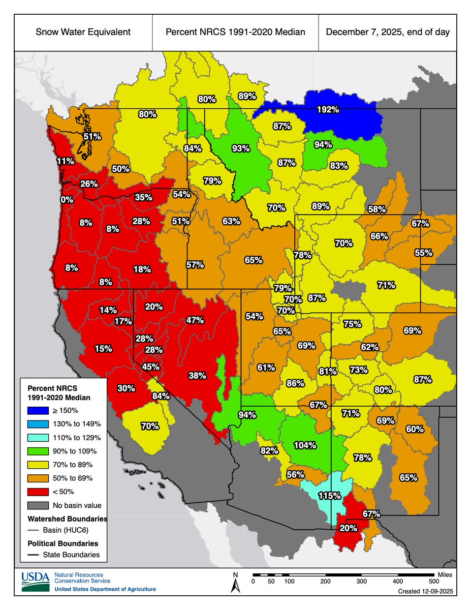
First 2025-26 Snow Drought Update
Much of the West is in a snow drought as warm temps have brought rain to many areas that would normally get snow. Snow cover across the West was the lowest for December 7 in at least 25 years.
Get the full update: https://t.co/O1sv4xf8mg @NOAA
Atmospheric rivers tend to be warm, leading to mostly rain rather than snow, even in our mountains.
As round two moves in today, we aren't likely to see much improvement in our mountain snowpack as unseasonably warm temperatures continue.
Map from:
🔗 https://t.co/5h6qUgm52T
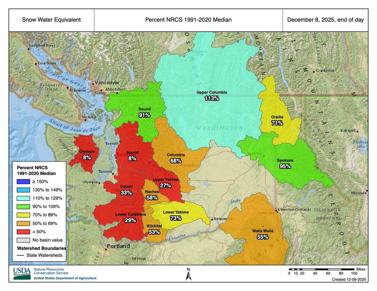
This major rain event is not shaping up to be a big snow producer in the mountains so far.
SWE at mountain stations from midnight on the 7th to midnight on the 8th (last night) shows little change.
#waclimate#wawx
Data from 🔗 https://t.co/5h6qUgm52T
The deadline to fill out the PNW Water Year 2025 survey was extended to Friday, December 12th! ☀️🌧️
If you experienced impacts from abnormally dry or wet conditions anytime from 10/1/2024 – 9/30/2025, we'd love to hear from you!
🔗 Take the survey: https://t.co/T6ksyuxaSP
Happy 2026 Water Year! Fill out the PNW Water Year 2025 Impacts Survey to let us know how WA, OR, and ID were impacted by abnormally dry or abnormally wet conditions during the 2025 water year (Oct 1, 2024 - Sep 30, 2025). Open through Nov 26, 2025.
https://t.co/T6ksyuxaSP
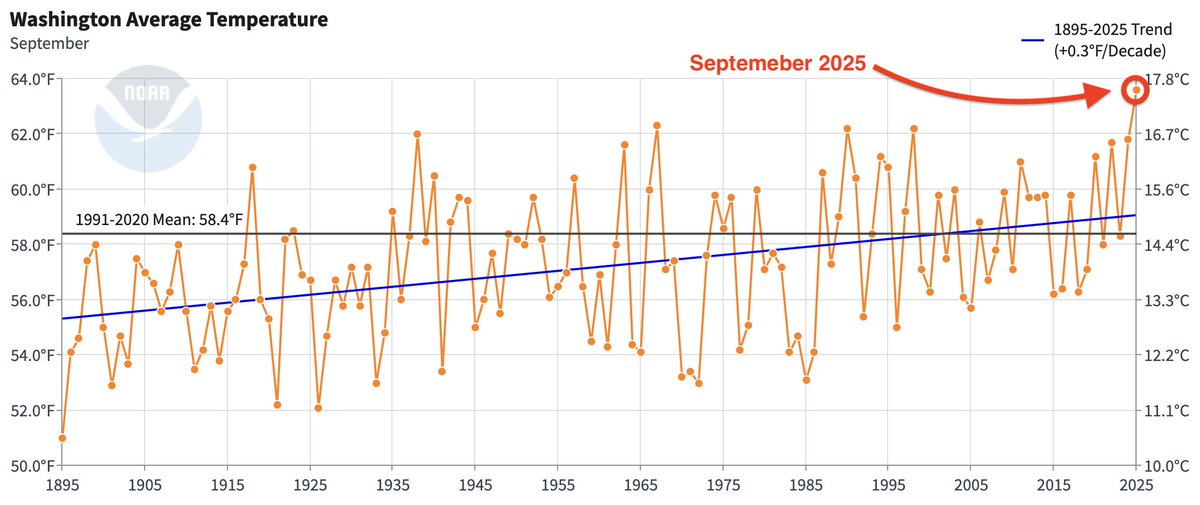
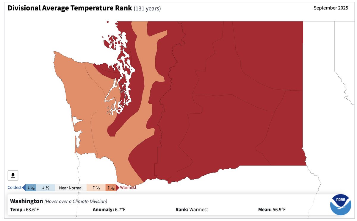
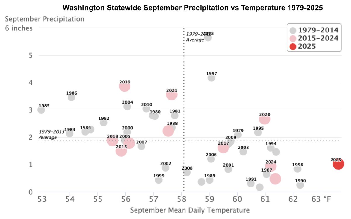
Now that NCEI data is flowing again, it is time to take a look at just how warm September 2025 was statewide:
September was the warmest September in WA back to at least 1895! Temperatures were +5.2ºF above normal for the month.
Source: NCEI Climate at a Glance
The November Newsletter is here! 🗞️📰
Read on for a statewide recap of the 2025 Water Year, weather and climate conditions in October, and a look at the seasonal outlook for the next 3 months.
https://t.co/880c2BcKWa
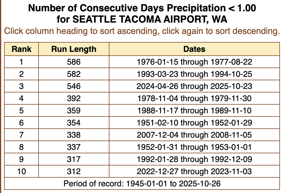
SeaTac Airport reported 1.04" of rainfall on Friday, October 24th ending SeaTac's impressive 546-day streak of daily total rainfall below 1.00". This was the third longest streak on record (records began at SeaTac in 1945).
The October 2025 Newsletter is here! Sept. was likely the warmest Sept. on record, and statewide drought continues. La Niña conditions are now in effect, and wetter than normal conditions are expected Oct.-Dec.
Read about recent and upcoming conditions:
https://t.co/1KYGAAg6C0
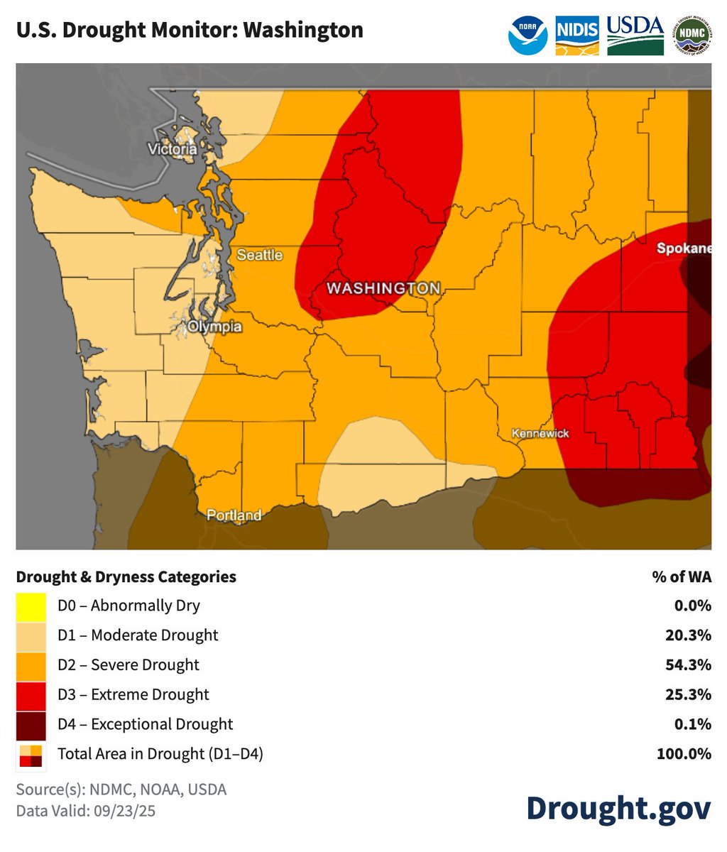
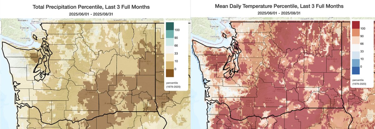
Spotlight on Washington State, which is ending the water year in rough shape.
100% of WA is in drought
25.3% is in Extreme Drought (D3)
Much of western WA has precip deficits over 10” with some areas over 20” since Oct 1, 2024
https://t.co/QYNv3f8PPC @NOAA@WAstateclimate
@CIG_UW EVENT RESCHEDULED: This event has been rescheduled to October 16th @ 1pm PT. If you are already registered for this event, your registration will carryover and you should have receive an updated calendar invite for the 16th.
https://t.co/C9TA6EE7kO
Join us on Thurs, Sept. 25th @ 11am PT for a discussion of the resources available for understanding climate risk in the PNW! 🌊🌲🏔️
This is the latest installment of the Our Climate Future webinar series organized by @CIG_UW
Register here: https://t.co/C9TA6EDzvg
Seattle yearly rainfall through today 5th driest on record since 1945. Top 5...
1. 13.35" 1985
2. 13.82" 1973
3. 14.67" 2023
4. 15.09" 1979
5. 15.57" 2025**
We will add to the total with rain overnight Saturday into Sunday. Predicted rain amounts in image. #wawx
Odds tilt toward favoring wetter than normal conditions across the state from October-December with greater uncertainty for temperatures.
Trop. Pacific SSTs continue to cool. La Niña conditions may develop in the next couple of months.
https://t.co/MAGB5FB6th
Summer featured record heat and record dryness across large portions of the state. Read our August and Full Summer 2025 Climate Summary to learn more!
https://t.co/OerlAOvCMD
A La Niña Watch is in place. What might this mean for the upcoming fall and winter in Washington?
Read our latest Climate Outlook to learn more:
https://t.co/2k9kAlWQJ4
What can you expect over the next couple of weeks? More persistent summer heat continues statewide.☀️