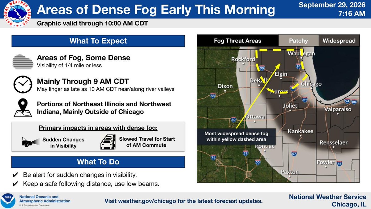
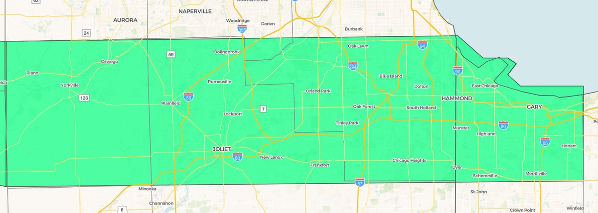
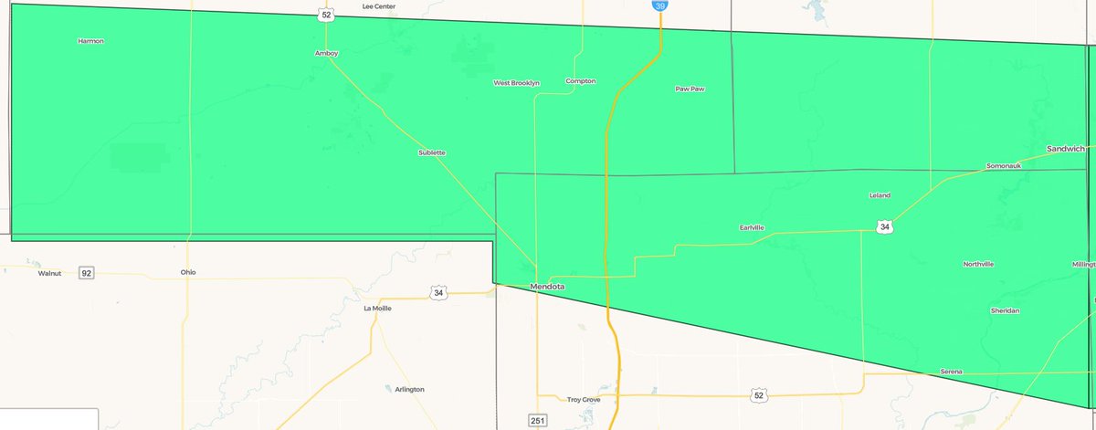
Fog is ongoing early this morning across portions of northeast Illinois and northwest Indiana. Some of this fog is dense, particularly in far northeastern Illinois. Be prepared for sudden changes in visibility during the morning commute! #ILwx#INwx
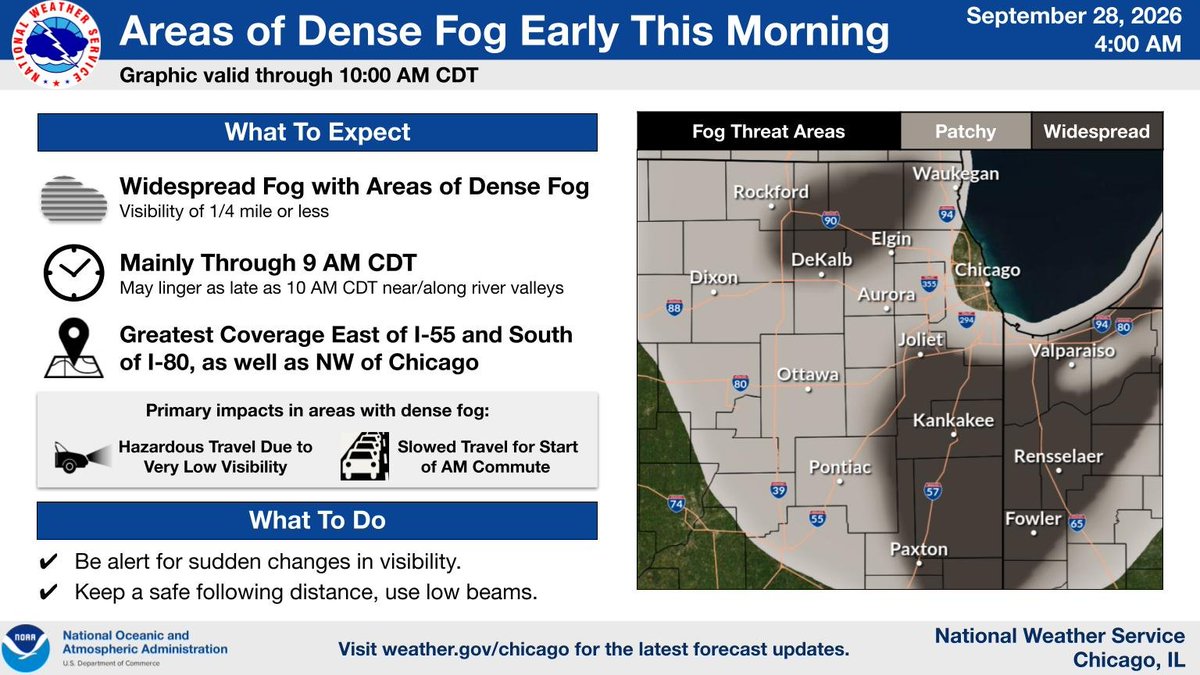
Fog is expanding in coverage early this morning across the area, particularly east of I-55 and south of I-80 where a Dense Fog Advisory is in effect as well as areas NW of Chicago. Be prepared for sudden changes in visibility through the first part of the AM commute! #ILwx#INwx
Several rounds of heavy rainfall moved across northern Illinois and northwest Indiana late last week through this past weekend. Some areas received 6 to 7 inches of rain over four days and many experienced impacts from flooding. Thanks to all who submitted a rainfall report!
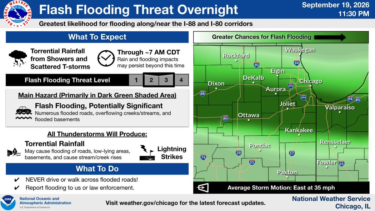
A corridor of torrential rainfall and t-storms is expected to set up near and along the I-88 and I-80 corridors overnight. Flash flooding (and potentially significant flash flooding) may occur across these areas before the heaviest rainfall tapers off after daybreak. #ILwx#INwx
(🧵3/4) Here is a look at the general rainfall trends through tonight. The greatest heavy rain and flooding threat is late this evening through early Sunday morning. #ILwx#INwx
(🧵1/4) Showers and storms with torrential downpours are expected to develop again across northern IL this evening and continue into Sun AM. This rain will fall over already saturated ground from the past day, increasing the risk for localized flooding. #ILwx#INwx
Waves of showers and storms this weekend will be capable of torrential downpours which may result in localized flooding, especially in poor drainage and low-lying areas. Some uncertainty in the placement of the heaviest rain remains, so stay tuned for updates. #ILwx#INwx
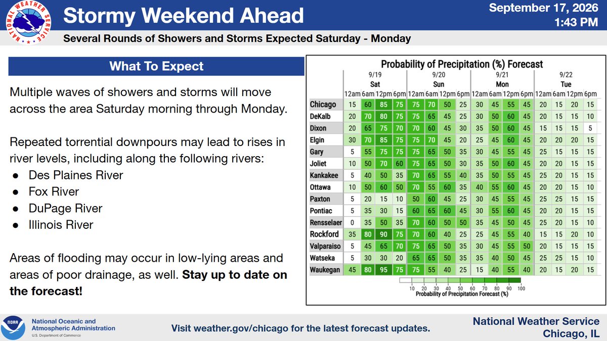
(🧵1/3) Waves of showers and thunderstorms Saturday through Sunday will likely result in rises on area rivers and possibly some localized river flooding. Make sure you stay updated on the latest forecast, especially if you live near a river! #ILwx#INwx
(🧵2/3) The waves of showers and storms this weekend will be capable of torrential downpours which may result in localized flooding, especially in poor drainage and low-lying areas. Some uncertainty in the placement of the heaviest rain remains, so stay tuned. #ILwx#INwx
Multiple waves of showers and storms may lead to rises in river levels and areas of flooding next week. Stay up to date on the forecast if you have outdoor plans this weekend or live along a river! #ILwx#INwx
Rounds of heavy-rain producin showers and thunderstorms are expected late tonight through Sunday night. Successive rounds of heavy rainfall could lead to localized flooding, including flooding of low-lying and poor drainage areas and potential rises on rivers. #ILwx#INwx
Traveling within the green shaded areas this morning? Prepare for water ponding on roadways and slowed traffic speeds due to torrential downpours in thunderstorms. The storms should clear the area later this morning in the 8am to 11 am timeframe from west to east. #ILwx#INwx
Torrential downpours in thunderstorms are expected tonight especially near and south of the Interstate 80 corridor. Localized flooding of low-lying areas may occur where the downpours are steadiest. Note that the morning commute looks wet tomorrow! #ILwx#INwx
[4:10 AM CDT 9/16] A corridor of heavier showers & t-storms is expected to develop again late tonight, mainly for areas near & south of a Dixon #ILwx to Valparaiso #INwx line southward to ~US-24 (dark green on map), with a corresponding threat for localized flooding into Thu AM.
Periodic showers and storms are expected overnight tonight, especially near and south of I-80. Some showers may become downpours and produce localized flooding in poor drainage areas.
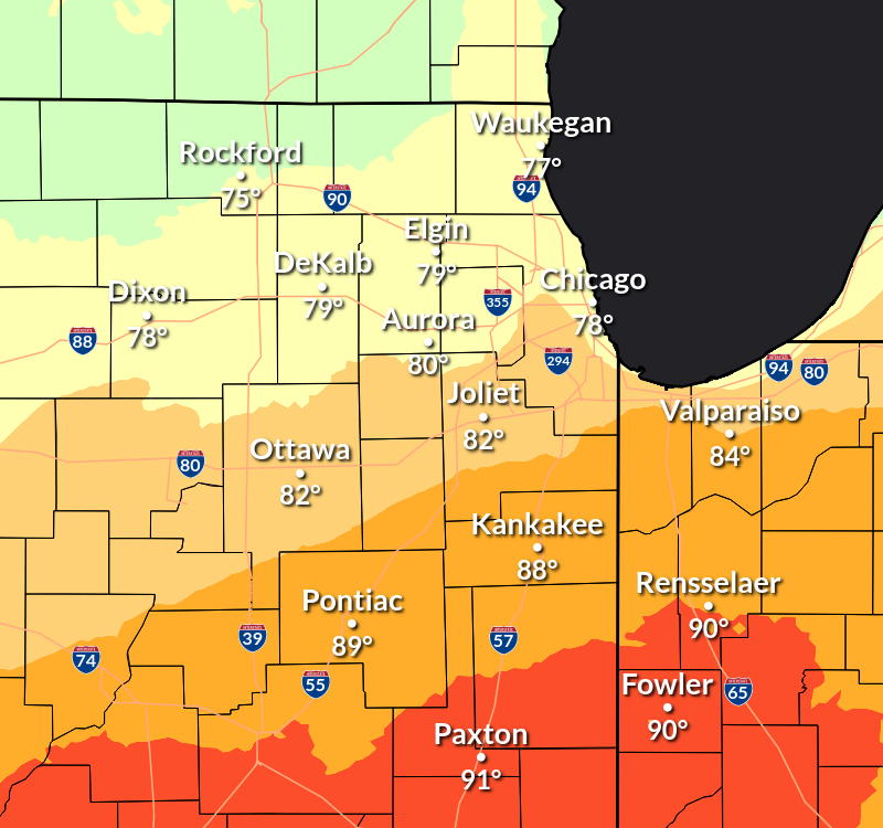
There will be a large gradient in high temperatures today across the area owing to clouds and showers across northern Illinois. We're still optimistic in some clearing this afternoon north of I-88, but it's possible we're still too warm near the Wisconsin state line. #ILwx#INwx
Expect periods of rain from showers and embedded thunderstorms this morning, with the highest coverage near and north of I-80 as depicted on the inset map. If you hear thunder, go indoors or into a hard metal topped vehicle. Use caution when driving in heavy rain. #ILwx#INwx
The first 4 days of September have been the hottest on record for both Chicago & Rockford. The average temperature in Chicago was 85.4° & 82.5° in Rockford. Both stations were 1.4° warmer than previous warmest opening 4 days to Sept which occurred back in 1960. #ilwx#inwx
Hot and humid conditions will continue through this evening, especially near and south of I-80. Slightly cooler conditions are expected tomorrow, but the humidity will persist for yet another day, with 100-105°F heat indices occurring again tomorrow PM south of I-80. #ILwx#INwx
[1:33 PM CDT Fri 9/3/2026] Map of heat headlines (current expiration time of 10pm CDT) in effect, with a Heat Advisory across northern #ILwx & northwest #INwx, except for Boone, McHenry, Lake IL, & northern & central Cook (#Chicago) Counties, which were canceled earlier today.






![NWSChicago's tweet photo. [4:10 AM CDT 9/16] A corridor of heavier showers & t-storms is expected to develop again late tonight, mainly for areas near & south of a Dixon #ILwx to Valparaiso #INwx line southward to ~US-24 (dark green on map), with a corresponding threat for localized flooding into Thu AM. https://t.co/e4ykzlvCGb](https://pbs.twimg.com/media/HSU67HJWgAANmJt.jpg)


![NWSChicago's tweet photo. [1:33 PM CDT Fri 9/3/2026] Map of heat headlines (current expiration time of 10pm CDT) in effect, with a Heat Advisory across northern #ILwx & northwest #INwx, except for Boone, McHenry, Lake IL, & northern & central Cook (#Chicago) Counties, which were canceled earlier today. https://t.co/PJiN1Bnahr](https://pbs.twimg.com/media/HRZJd_GbQAAtOg-.png)




