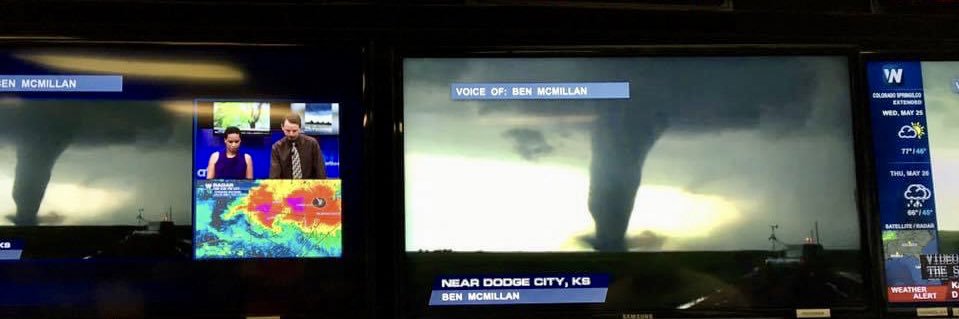
This is footage from Ben McMillan @WeatherLiveTV
Watched this on livestream, as they followed this massive wedge in. Ben is an EMT, he went straight to SAR, while Randy Walton was in the car in shock, he was totally unprepared to see this level of devastation, and couldn't handle it, and didn't know what to do.
The new chasers today zero metering tornadoes, need to be mindful, this started out as a mean stovepipe, and when it transformed into a mile wide wedge, the transition was in less than a minute, no time to escape if you are zero metering, they turn deadly extremely fast.😭
5/20/2013 Moore, OK EF5 Tornado and deadly aftermath B-Roll https://t.co/gwVAyJDD73 via @YouTube
Very sad situation now here in Sarasota looking out towards the outer barrier islands. Power flashes have now started dotting the sky, and Bird Key is being swallowed by extremely strong winds and storm surge as #Milton’s eye drifts slowly closer. #FLwx#HurricaneMilton
The tragic story of this hurricane is watching storm surge move into areas with piles of debris that have not been cleaned up from previous storms. A double #Milton tragedy if you will… here in downtown St. Amandis Key, outside Sarasota. #HurricaneMilton#FLwx
Water level rises on Sarasota Bay will continue over the next hour until a greater storm surge threat develops later into this evening. #Milton#HurricaneMilton#FLwx
As winds shift around the center of Hurricane #Milton, storm surge is going to become a big concern very quickly. Here in Venice, Florida the city sewer system is already starting to be overwhelmed. Once winds shift to on-shore it will be a fast transition to completely flooded roadways. #FLwx #HurricanMilton
The International Space Station just orbited above Hurricane Milton as it is re-intensifying over the southern Gulf of Mexico.
Spectacular view from space.
As what is expected to be "Hurricane Milton" forms in the Gulf of Mexico today, those on Florida's western coast should have a plan.
Storms of this magnitude (Cat 3+) are incredibly rare in this part of the world. Check out the reporting my team and I did regarding this back in 2022. Please take this storm seriously... and evacuate if needed. #MILTON
https://t.co/gOCiwwEwGS
Conditions on the Gulf of Mexico deteriorating rapidly. This is Alligator Drive in coastal parts of Franklin County, FL. As #Helene approaches, this area could see up to 20 feet of storm surge in which officials are saying could be “unsurvivable“ #FLwx#HurricaneHelene