This is going to be a billion-dollar disaster across the Midwest.
View from space shows a violent line of storms, with embedded tornadoes roaring through Chicago with severe thunderstorm warnings including hurricane-force wind gusts up to 100 mph. Winds as high as 130 mph were detected just above the surface.
The complex of storms, which developed over eastern Iowa this morning, will continue racing southeast into Indiana and Ohio and is expected to be classified as a derecho.
At least 47 people have died following the powerful 7.4-magnitude earthquake that struck near San José del Palmar in western Colombia, the highest magnitude earthquake registered in the country in the last decade. READ MORE: https://t.co/ww4D9QCKpx
🚨💨 SMOKECAST | MONDAY 8/10
Smoke is stretching across a HUGE portion of the United States today.
🔥 From the Pacific Northwest through the northern Plains and Midwest, some of the heaviest smoke concentrations are forecast — while at least some smoke reaches across much of the country.
🟣 PNW: Extremely heavy concentrations near active fires
🔴 Northern Rockies/Plains: Large plume spreading east
🟠 Midwest: Widespread smoke overhead
🟢 Much of the East: Lighter concentrations filtering through
⚠️ Remember: smoke overhead ≠ unhealthy surface air. Air quality impacts depend on how much of that smoke mixes down to ground level.
Watch the animation below 👇
#Smoke #Wildfires #AirQuality #Weather
🚨💨 SMOKECAST — Washington & Oregon | Sunday 8/9 → Monday 8/10
The PNW is split in two.
🔥 WASHINGTON: A massive amount of wildfire smoke remains over and east of the Cascades, with the heaviest plume across eastern WA and into ID.
🌲 WESTERN WA: Seattle, Puget Sound & the coast stay comparatively clear as the bulk of the smoke remains east.
🔥 OREGON: Smoke continues across central/eastern Oregon, with several concentrated plumes showing up in the forecast.
👀 Watch the loop through Monday — you can really see the Cascades acting as a dividing line between the smoky interior and much clearer air to the west.
⚠️ This is total-column smoke, so not everything shown here is reaching the surface.
#Smoke #Wildfires #Washington #Oregon #PNW
🚨💨 CONUS SMOKECAST — Sunday 8/9
That is a LOT of smoke across the northern U.S. today.
🔥 PNW / NORTHERN ROCKIES: Thick wildfire smoke continues across WA, OR, ID & MT.
🌫️ MIDWEST: Smoke pours east across the Dakotas, MN, WI and the Great Lakes.
➡️ EAST: The plume keeps going, with smoke spreading toward the Northeast & Mid-Atlantic.
☀️ Meanwhile, much of California & the Southwest are looking relatively clear.
⚠️ This is total-column smoke, so some of what you’re seeing is well above the surface and may not impact air quality.
Watch how massive the plume becomes as it crosses the country 👀
#Smoke #Wildfires #Weather
🚨 CONUS SMOKECAST — Saturday 8/8
🔥 A massive plume of wildfire smoke continues to spread across the U.S. today.
🟣 PACIFIC NORTHWEST: The worst of it. Washington, Oregon & Idaho remain buried beneath extremely dense smoke, with major fires across the region continuing to pump smoke into the atmosphere.
🔴 NORTHERN ROCKIES: Montana & Wyoming are heavily impacted as the western smoke plume expands eastward.
🟠 CENTRAL/NORTHERN PLAINS: Smoke stretches through the Dakotas, Nebraska, Kansas & into the Upper Midwest. Expect widespread hazy skies even far from the fires.
🟡 MIDWEST → GREAT LAKES: The plume continues into Iowa, Missouri, Illinois, Wisconsin, Michigan, Indiana & Ohio, with another corridor pushing toward the Northeast.
🟢 SOUTHWEST: Arizona, New Mexico, Utah & Colorado see pockets of smoke, but generally much less concentrated than areas farther north.
⚪ CALIFORNIA: Much of CA escapes the enormous inland plume today, although localized smoke remains possible around active fires.
🌫️ BOTTOM LINE: The northern half of the country is dealing with an enormous west-to-east smoke transport event today — with the PNW and Northern Rockies firmly in the bullseye.
📍Forecast image: Pivotal Weather
One thing I really like about this image for your Wild Weather Wizard account is how immediately understandable it is. You almost don’t need to explain the meteorology: the gigantic PNW → Rockies → Plains → Great Lakes smoke corridor jumps off the screen.
I’d also make the first two lines the hook, because that’s what people see before expanding the post:
🚨 MASSIVE SMOKE PLUME ACROSS THE U.S.
Wildfire smoke from the West is forecast to stretch thousands of miles across the northern U.S. today. 🌫️🔥
WOW! Euro is really ramping up #monsoon moisture, especially from the middle of next week and beyond.
Let's just hope that we don't WASTE it this time around.
Monsoon Season rain totals:
Las Vegas: .02" Normal: 1.05"
Phoenix: .46" Normal: 2.43"
Tucson: 2.40" Normal: 5.69"
Flagstaff: 3.76" Normal: 7.68"
@News3LV@NWSVegas #WeatherAuthority #Vegas #Vegasweather #nvwx #monsoonseason @NWSFlagstaff@NWSTucson@NWSPhoenix
🌧️ SO WHAT DOES THIS HAVE TO DO WITH EL NIÑO?
An important distinction:
⚠️ An ARkStorm is NOT forecast for Winter 2026–27.
⚠️ A very strong El Niño does NOT mean an ARkStorm will occur.
El Niño changes the odds and patterns of weather — it doesn’t dictate individual storms months in advance.
But with another potentially powerful El Niño developing, the Great Flood of 1861–62 is an incredible reminder of what California’s climate is capable of producing.
The question isn’t whether California can experience a megaflood.
History tells us that it can.
🚨 EL NIÑO & CALIFORNIA’S “ARKSTORM”
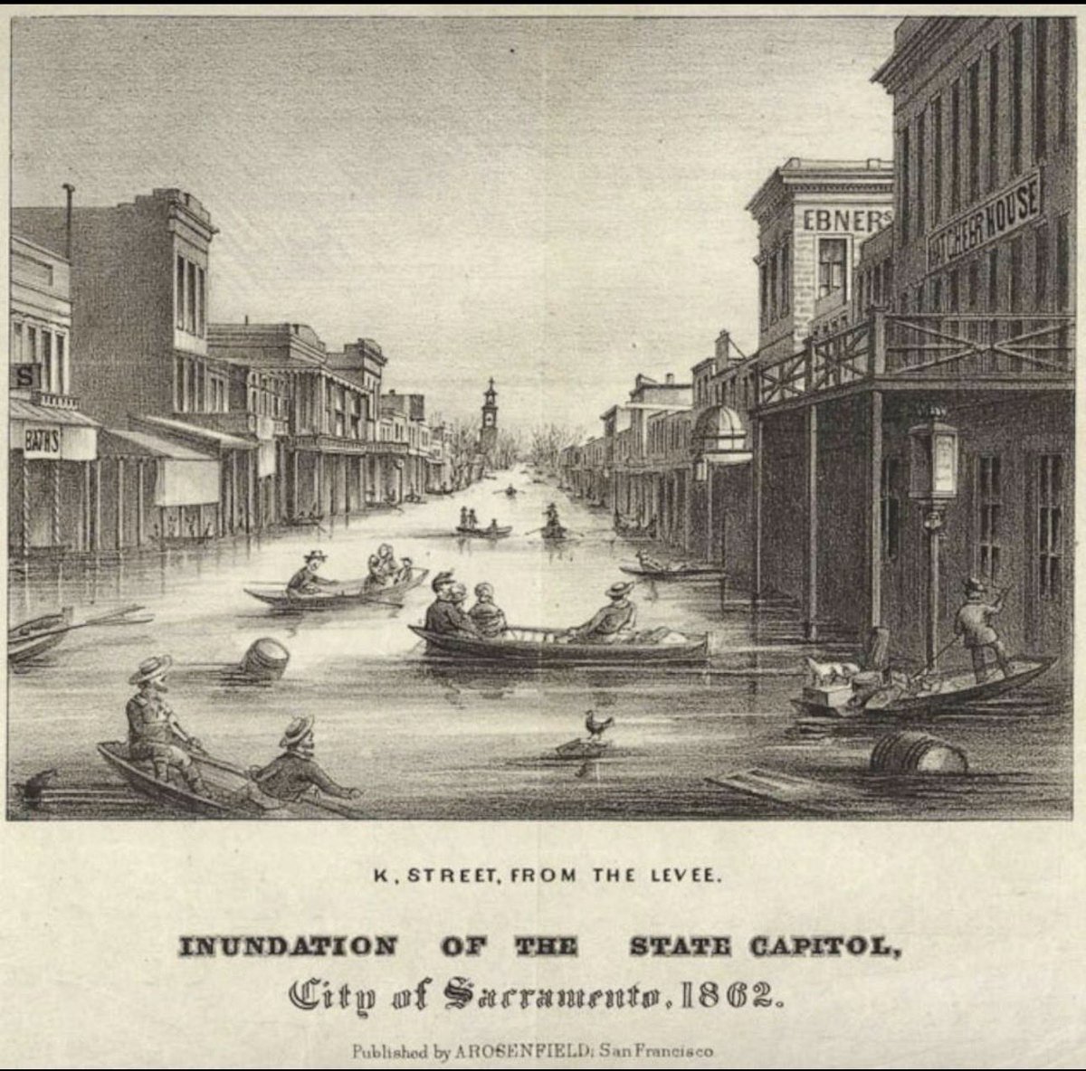
With reports highlighting the potential for a very strong El Niño, let’s revisit one of the most extreme weather disasters in California history.
In 1861–62, California experienced a flood so enormous that parts of the Central Valley became an inland sea.
And scientists have modeled what could happen if something similar struck California today.
🧵👇
🤯 1861–62 MAY NOT HAVE EVEN BEEN THE WORST.
Geologic evidence studied by scientists suggests California has experienced multiple megafloods over the past ~1,800 years, including events potentially larger than 1861–62.
California’s quiet periods can make events like these feel impossible.
The geological record says otherwise.
Will it snow a lot this winter? 👀
Because of El Niño, there's probably going to be more moisture and storms, but Arctic air looks less frequent.
Timing will be everything. Big moisture + short-lived cold can still = big snows.
More maps, have fun! https://t.co/DG0UzitUXM
🕰️ T H I S D A Y I N W E A T H E R | August 7, 1924
🌪️ 102 YEARS AGO TODAY — A VIOLENT TORNADO TORE THROUGH WISCONSIN
On August 7, 1924, a devastating tornado carved a path through western Wisconsin, traveling southeast from near Osseo toward Black River Falls.
The destruction was extraordinary.
🏚️ Around 50 farms were struck along the tornado’s path. Farmhouses were swept away, buildings were unroofed, and debris was scattered across the countryside. In the town of Northfield, structures lost their roofs as the storm passed through.
Tragically, four people were killed. One person died when a home was leveled, a boy was killed while running toward a storm cellar, and two others died when farm homes were swept away near Black River Falls.
Damage was estimated at roughly $200,000 in 1924 dollars — an enormous loss for the rural communities in its path.
Meteorologists later estimated the tornado produced F4-level damage — the kind of destruction associated with a violent tornado. Remarkably, its path roughly followed what is now the Interstate 94 corridor toward Black River Falls.
📸 And this photograph was taken that very day.
More than a century later, it gives us a haunting look at what residents walked outside to find after the storm — a farmhouse ripped open and an automobile tossed upside down.
Why remember a storm from 1924?
Because severe weather didn’t begin with Doppler radar, smartphones or storm chasers. Communities like these faced violent tornadoes with nothing resembling the warning technology we have today.
Every old photograph like this is a reminder of how far weather forecasting has come — and why the history behind these storms is worth preserving.
📸 Sherwin Gillett / Wisconsin Historical Society
📅 August 7, 1924
#WIwx #WeatherHistory
🚨 S M O K E C A S T | WA + OR — Friday 8/7
🌫️ A massive blanket of wildfire smoke continues across the Inland Northwest today.
🔥 Eastern WA: Thick, widespread smoke with locally poor visibility
🌲 Central WA: Persistent smoke, especially near active fires
🌫️ Central/Eastern OR: Another smoky day with periods of dense smoke
🌊 West of the Cascades: Generally cleaner, but some haze may work into the valleys
The HRRR forecast shows a sharp east-to-west divide today — heavy smoke inland, much clearer toward the Pacific.
⚠️ Conditions can change quickly near active fires. Check your local AQI before extended time outdoors.
📍 HRRR Near-Surface Smoke Forecast
#WAwx #ORwx #WildfireSmoke