#ONStorm#ONwx It has now been 4 years now since the historic derecho slammed Southern Ont and Quebec, causing several twisters to drop, notable one being the EF2 tornado in Uxbridge. This derecho has travelled 998 km, strongest wind gusts peaking 147 km/h, and killed 16 people.
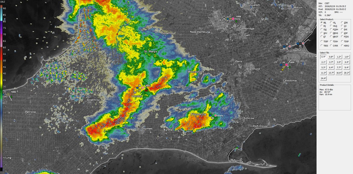
Many people this morning were treated to a suprise this morning with the development of thunderstorms overnight, bringing in a ton of lightning with it and heavy downpours. #ONStorm#onwx
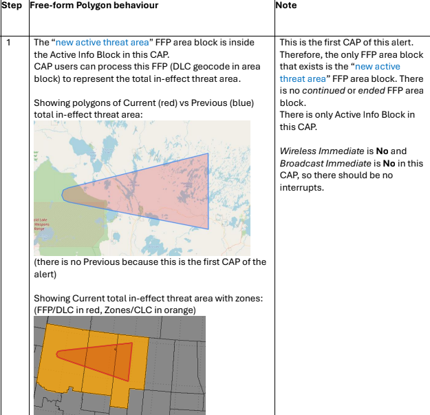
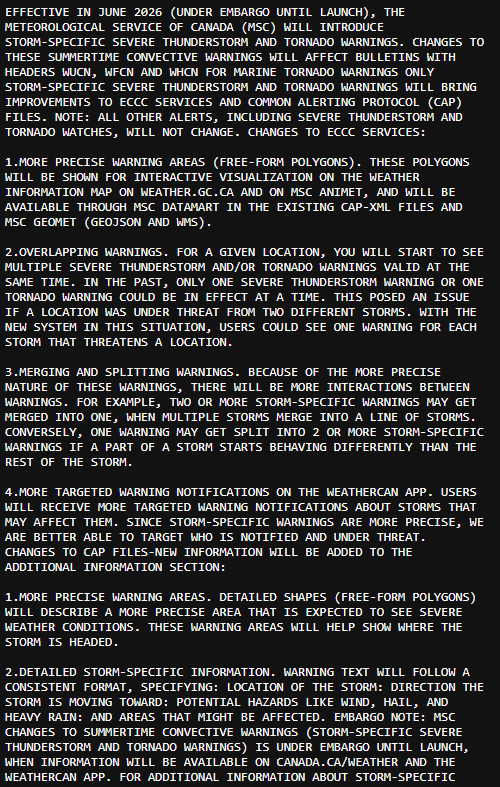
ECCC will be going ahead with free-form SVR/TOR polygons. They've been planning to launch this year since summer last year, should launch sometime after June 15, 2026 after they conclude with testing. #ONStorm#Onwx
@ATLAreaWx@ametsoc@wxmann@SteveSkojec Meteorologists study the Earth's atmosphere, weather patterns, and forecasting, whereas people who study meteors (space rocks) are usually astronomers or meteoriticists
This event absolutely busted from a public perception standpoint, we don’t have to lie to ourselves here.
This illustrates perfectly what I dislike about pperf hindcasts. Completely ignores the aspect of public perception in favor of statistical verification.
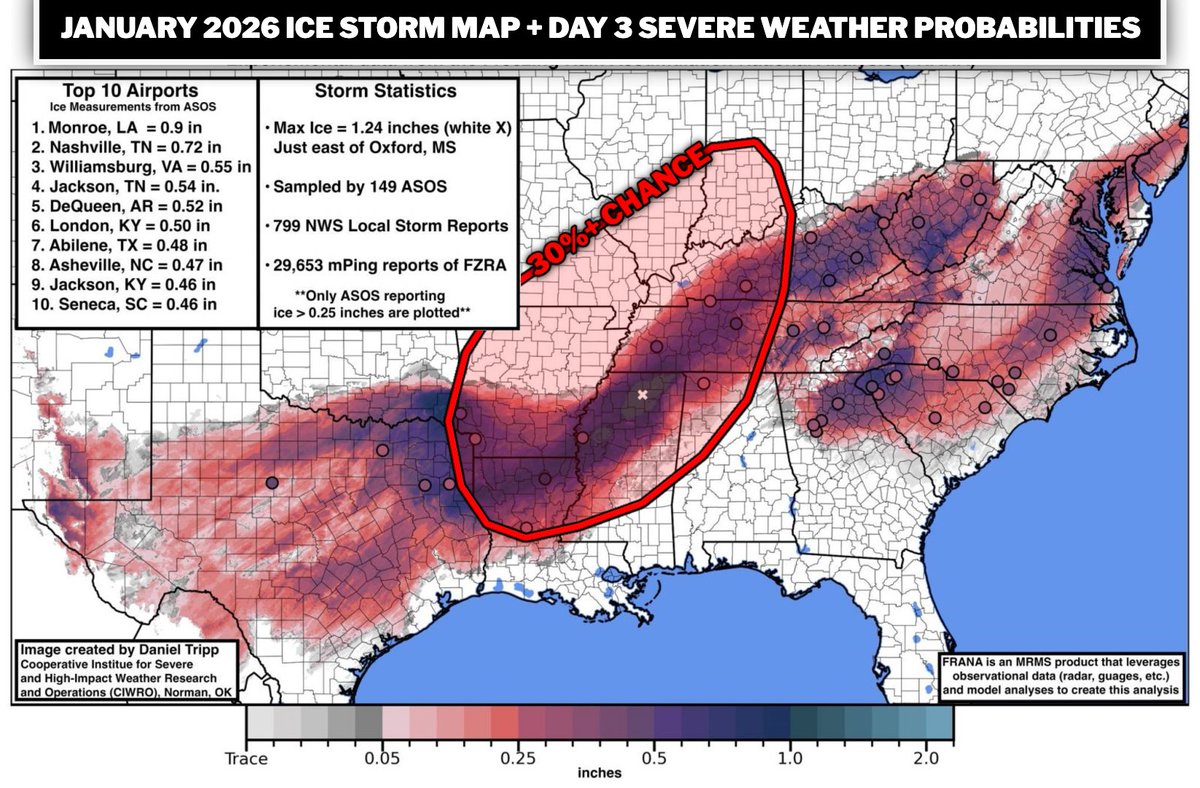
One thing that isn't really being talked about much but needs to is the damage effects that our existing catastrophic ice storm from January left and how this high probability widespread severe weather threat could easily cause severe damage if we end up seeing gusts of 70mph+.
This ice storm did tremendous damage to trees and existing power infrastructure. Most of these areas have not fully recovered and will not fully recover for a good bit. There is still a lot of weak damaged trees out there. We have already seen existing ice storm impacts effect power loss in a few previous events here in middle Tennessee, but with this being a widespread threat, we all need to be preparing for the legit chance of more longer lasting power outages. More info will come over the next day or so, but please stay glued to the forecast.
LINK: https://t.co/3n3wfUyPoq
In-depth look at the upcoming changes to the Storm Prediction Center severe weather outlooks. I sit down with SPC meteorologists Evan Bentley and Chris Broyles to discuss these changes in detail, including why they were necessary, what the new Conditional Intensity Groups (CIG) represent for each severe hazard, and lots more. I also work through some examples of the new outlooks at the end.
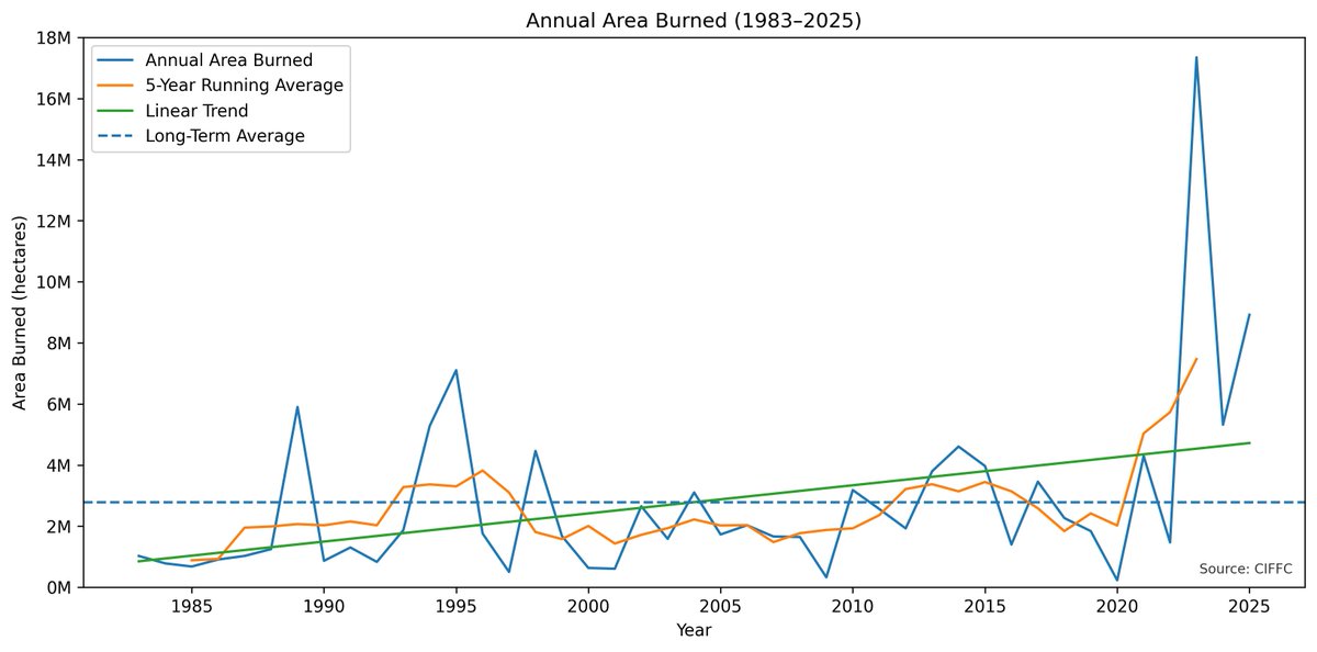
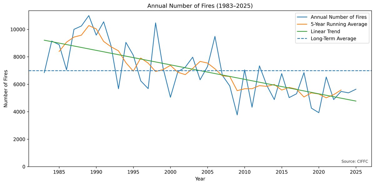
In Canada, the annual number of wildfires is indeed decreasing.
At the same time, annual area burned is *increasing* - especially after 2020, when this study was published.
This has been due to increased fire weather conditions (hot, dry, windy), allowing some fires to grow very large - especially in remote areas of the boreal.
So while people are getting smarter about starting fires, the amplified warming in higher latitude regions like Canada is creating conditions more conducive to aggressive burning when ignitions do occur, whether from humans or lightning.
This trend may continue, with Canada's forests continuing to be more of a carbon source than a sink, as has been the case since the early 2000s:
https://t.co/NzRdt4cS0A
For instance, in Canada's record-breaking 2023 season, which burned over 15 million hectares (an area larger than Greece), wildfires generated 647 Teragrams of Carbon - roughly equivalent to the annual fossil fuel emissions of a large country:
https://t.co/nd2reDp3V3
In my view, recent increases in area burned in Canada may be the result of a specific climate regime (bolstered by AGW) that has been ongoing since late 2020:
https://t.co/VaTReqcdIv
In any case, just because trends in area burned may be decreasing in other areas, doesn't mean they are decreasing everywhere.